| USA - UNITED STATES | |||||
| CHINO AIRPORT | |||||
| Description | |||||
| Location | Chino CA - California - Western States | ||||
| Location | 7000 Merrill Ave # 1, Chino, CA | ||||
| Latitude - Longitude | + 33°58'34" -117°38'18" 33.976111 -117.638333 | ||||
| UTM Coordinates | X = 441034.373 - Y = 3759690.786 - Zone 11S | ||||
| Aerial photo / Map (*) |  OpenStreetMap - Google Maps - Bing Maps - Flash Earth - Wikimapia - Microsoft Research Maps - MapQuest OpenStreetMap - Google Maps - Bing Maps - Flash Earth - Wikimapia - Microsoft Research Maps - MapQuest | ||||
| Altitude AMSL | 191 m - 627 ft | ||||
| Inauguration | 1953 | ||||
| Closing | |||||
| Designer | |||||
| Sources and links (Translation) (**) |
| ||||
| Chino Airport | |||||
| Description | |||||
| Years | |||||
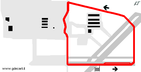
| Direction |  Clockwise Clockwise | ||||
 Proposal Proposal |
NO | ||||
| No longer operational | YES | ||||
| Car Circuit | YES | ||||
| Motorbike circuit | |||||
| Type | Airfield course | ||||
| Inauguration | |||||
| Closing | |||||
| Last update of this page | May 3rd 2003 | ||||
| Info last update | |||||
| Designer | |||||
| Distinctive points | |||||
| length | 2414 m | 7920 ft | 1.5 mi | (1) | |
Chino Airport
| Updates | |||||||
| Date | Track layout | Years | Description by | Map by | Thanks to | Note | |
| May 3rd 2003 | Guido de Carli | New | Description | ||||
| Not all eventual updates issued in last years are already visible in this list | |||||||


