| AUS - AUSTRALIA | |||||||||||||
| LONGFORD | |||||||||||||
| Description | |||||||||||||
| Location | Longford TAS - Tasmania | ||||||||||||
| Location | 19 km - 12 mi from Launcheston | ||||||||||||
| Latitude - Longitude | - 41°34'44" +147°07'25" -41.578889 147.123611 | ||||||||||||
| UTM Coordinates | X = 510304.387 - Y = 5396970.15 - Zone 55G | ||||||||||||
| Aerial photo / Map (*) |  OpenStreetMap - Google Maps - Bing Maps - Flash Earth - Wikimapia - NearMap OpenStreetMap - Google Maps - Bing Maps - Flash Earth - Wikimapia - NearMap | ||||||||||||
| Altitude AMSL | 136 m - 446 ft | ||||||||||||
| Inauguration | 1953 | ||||||||||||
| Closing | March 4th 1968 | ||||||||||||
| Designer | |||||||||||||
| Sources and links (Translation) (**) |
| ||||||||||||
| Longford | |||||
| Description | |||||
| Years | 1973 | ||||
| Direction |  Clockwise Clockwise | ||||
 Proposal Proposal |
NO | ||||
| No longer operational | YES | ||||
| Car Circuit | YES | ||||
| Motorbike circuit | |||||
| Type | Road course | ||||
| Inauguration | 1953 | ||||
| Closing | March 4th 1968 | ||||
| Last update of this page | December 19th 2007 | ||||
| Info last update | |||||
| Designer | |||||
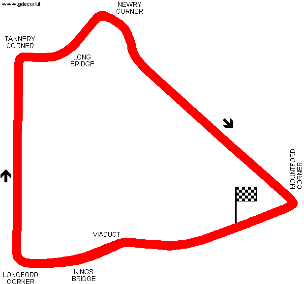
| Distinctive points | Viaduct - Kings Bridge - Longford Corner - Tannery Corner - Long Bridge - Newry Corner - Mountford Corner | ||||
| length | 7242 m | 23759 ft | 4.5 mi | (2) | |
| length | 7200 m | 23622 ft | 4.474 mi | (1) | |
| Min width | 6.08 m | 20 ft | (1) | ||
Longford
| Updates | |||||||
| Date | Track layout | Years | Description by | Map by | Thanks to | Note | |
| March 27th 2009 | Guido de Carli | David Griac (jpm) | Update | Description | |||
| December 19th 2007 | Lorenzo Tommasi | Update | Description | ||||
| May 3rd 2004 | Guido de Carli | Guido de Carli | Update | Description with map | |||
| September 4th 2003 | Guido de Carli | Update | Description | ||||
| July 18th 2003 | Guido de Carli | New | Description without map | ||||
| Not all eventual updates issued in last years are already visible in this list | |||||||


