| USA - UNITED STATES | |||||||||
| BRANDY STATION | |||||||||
| Description | |||||||||
| Location | Brandy Station VA - Virginia - Southern States | ||||||||
| Location | |||||||||
| Latitude - Longitude (approx) | + 38°30'07" - 77°53'37" (approx) 38.501944 -77.893611 (approx) | ||||||||
| UTM Coordinates (approx) | X = 247665.697 - Y = 4265477.751 - Zone 18S (approx) | ||||||||
| Aerial photo / Map (*) |  OpenStreetMap - Google Maps - Bing Maps - Flash Earth - Wikimapia - Microsoft Research Maps - MapQuest OpenStreetMap - Google Maps - Bing Maps - Flash Earth - Wikimapia - Microsoft Research Maps - MapQuest | ||||||||
| Altitude AMSL (approx) | 100 m - 328 ft (approx) | ||||||||
| Inauguration | |||||||||
| Closing | |||||||||
| Designer | |||||||||
| Sources and links (Translation) (**) |
| ||||||||
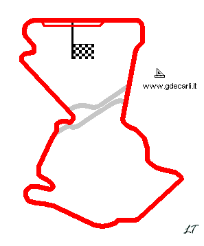
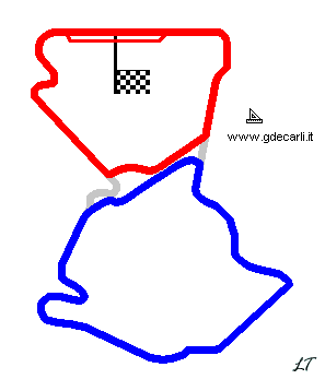
| Brandy Station | |||||
| Description | |||||
| Years | |||||
| Direction |  Clockwise Clockwise | ||||
 Proposal Proposal |
YES
| ||||
| Proposal not developed | YES | ||||
| Car Circuit | |||||
| Motorbike circuit | |||||
| Type | Permanent | ||||
| Inauguration | |||||
| Closing | |||||
| Last update of this page | May 17th 2003 | ||||
| Info last update | |||||
| Designer | |||||
| Distinctive points | |||||
Long course
| Updates | |||||||
| Date | Track layout | Years | Description by | Map by | Thanks to | Note | |
| April 25th 2007 | Guido de Carli | Update | Description | ||||
| May 16th 2003 | Guido de Carli | New | Description | ||||
| Not all eventual updates issued in last years are already visible in this list | |||||||


