| SUI - SWITZERLAND | |||||||||||||||||||||||||||||
| ERLEN | |||||||||||||||||||||||||||||
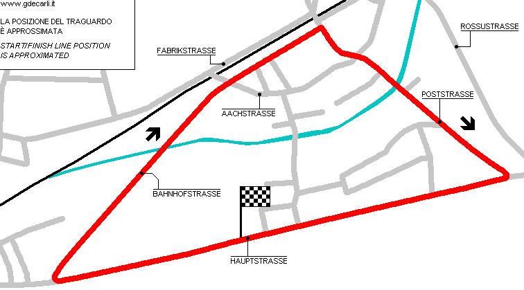
| Description | Street circuit used in 1950s; for sure in 1950-1951, maybe also before and later. Pits were in start/finish area, right of the track; main grandstand was on the left. I have no more info. | ||||||||||||||||||||||||||||
| Location | Erlen TG - Thurgau - Ostschweiz | ||||||||||||||||||||||||||||
| Location | Erlen, in North East Switzerland | ||||||||||||||||||||||||||||
| Latitude - Longitude | + 47°32'48" + 9°13'30" 47.546667 9.225 | ||||||||||||||||||||||||||||
| UTM Coordinates | X = 516930.496 - Y = 5265940.671 - Zone 32T | ||||||||||||||||||||||||||||
| Swiss national coordinates | Y = 734470 - X = 267746 | ||||||||||||||||||||||||||||
| Aerial photo / Map (*) |  OpenStreetMap - Google Maps - Bing Maps - Flash Earth - Wikimapia - map.search.ch OpenStreetMap - Google Maps - Bing Maps - Flash Earth - Wikimapia - map.search.ch | ||||||||||||||||||||||||||||
| Altitude AMSL | 450 m - 1476 ft | ||||||||||||||||||||||||||||
| Inauguration | |||||||||||||||||||||||||||||
| Closing | |||||||||||||||||||||||||||||
| Designer | |||||||||||||||||||||||||||||
| Sources and links (Translation) (**) |
| ||||||||||||||||||||||||||||
| Erlen | |||||
| Description | |||||
| Years | 1948?÷1950÷1951÷... | ||||
| Direction |  Clockwise Clockwise | ||||
 Proposal Proposal |
NO | ||||
| No longer operational | YES | ||||
| Car Circuit | YES | ||||
| Motorbike circuit | |||||
| Type | Road course | ||||
| Inauguration | |||||
| Closing | |||||
| Last update of this page | January 19th 2011 | ||||
| Info last update | |||||
| Designer | |||||
| Distinctive points | Hauptstrasse - Bahnhofstrasse - Poststrasse | ||||
| length | 2800 m | 9186 ft | 1.74 mi | (6) | |
| length | 2800 m | 9186 ft | 1.74 mi | (7) | |
| length | 2816 m | 9239 ft | 1.75 mi | (5) | |
| length | 2736 m | 8976 ft | 1.7 mi | Calculated from aerial photo (*) | (4) |
Erlen
Due to technical problems, temporarily it’s no longer possible to see the circuits on Google Maps embedded in the current page.
This feature will be restored as soon as I figure out how to do (any help would be appreciated!)
See this track layout with Google Earth
- milermeter.com
(milermeter.com can be used in your browser, without installing anything; Google Earth is a program that must be installed in your computer)
(Map shown here above can show at the same time all eventual layouts drawn. If you want to see only some of them, please go to Google Maps or Google Earth, by clicking on its own link)
| Updates | |||||||
| Date | Track layout | Years | Description by | Map by | Thanks to | Note | |
| June 2nd 2006 | 1948?÷1950÷1951÷... | Guido de Carli | Michel Marti | Update | Description | ||
| April 9th 2006 | 1948?÷1950÷1951÷... | Guido de Carli | Lorenzo Tommasi | Update | Description | ||
| November 14th 2005 | 1948?÷1950÷1951÷... | Guido de Carli | Guido de Carli | Barry Boor | New | Description with map | |
| Not all eventual updates issued in last years are already visible in this list | |||||||


