| PER - PERU | |||||||||
| BALNEARIO DE VENTANILLA | |||||||||
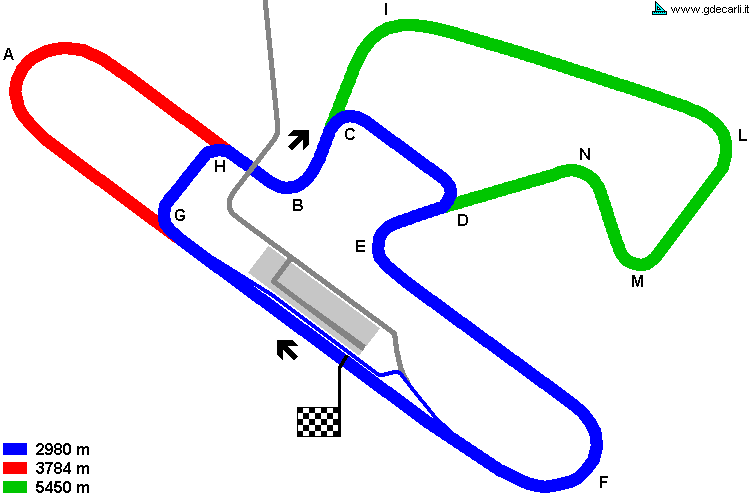
| Description | Proposal for a permanent circuit, derived from a previous proposal by Mr. Bacciagaluppi (I don’t know anything about it). Main track should have been 3784 m long, with a main straight 1200 m. A shorter circuit should have got from this one by using a link 260 m - 853 ft long. Moreover, a circuit 5450 m long could be proposed. The building site is essentially flat, a little ascending towards North East. Average speed should have been approx. 185 km/h - 115 mph on main circuit (1’14"0 approx.) and 160 km/h - 100 mph on the shorter one. Nearby the track there should have been a grass strip at least 5 m - 16.4 ft wide and a service road 3.5 m - 11.5 ft wide; access to the track should have been every 200-250 m (656-820 ft). Safety equipment should have included armco and steel safety nets (multiple on corners A, B, E and F). There should have been 40 boxes, 4 m - 13.1 ft deep; pit lane should have been 8.5 m - 27.9 ft wide and separated from the track by an island with service position 1.2 m - 4 ft wide. | ||||||||
| Location | Balneario de Ventanilla CAL - Callao | ||||||||
| Location | Few hundreds meters from Pacific Ocean, approx. 30 km - 19 mi North of Lima, along Panamericana and the highway from Lima to airport. | ||||||||
| Latitude - Longitude (approx) | - 11°52'22" - 77°07'32" (approx) -11.872778 -77.125556 (approx) | ||||||||
| UTM Coordinates (approx) | X = 268457.021 - Y = 8686630.334 - Zone 18L (approx) | ||||||||
| Aerial photo / Map (*) |  OpenStreetMap - Google Maps - Bing Maps - Flash Earth - Wikimapia OpenStreetMap - Google Maps - Bing Maps - Flash Earth - Wikimapia | ||||||||
| Altitude AMSL | 20 m - 66 ft | ||||||||
| Inauguration | |||||||||
| Closing | |||||||||
| Designer | |||||||||
| Sources and links (Translation) (**) |
| ||||||||
| Balneario de Ventanilla | |||||
| Description | |||||
| Years | 197? (< 1973) | ||||
| Direction | |||||
 Proposal Proposal |
YES
| ||||
| Proposal not developed | YES | ||||
| Car Circuit | YES | ||||
| Motorbike circuit | |||||
| Type | Permanent | ||||
| Inauguration | |||||
| Closing | |||||
| Last update of this page | May 8th 2005 | ||||
| Info last update | March 1973 | ||||
| Designer | Bacciagaluppi | ||||
| Distinctive points | |||||
| Balneario de Ventanilla | |||||
| Description | |||||
| Years | 1973 | ||||
| Direction |  Clockwise Clockwise | ||||
| Proposal |
YES
| ||||
| Proposal not developed | YES | ||||
| Car Circuit | YES | ||||
| Motorbike circuit | |||||
| Type | Permanent | ||||
| Inauguration | |||||
| Closing | |||||
| Last update of this page | December 11th 2005 | ||||
| Info last update | March 1973 | ||||
| Designer | |||||
| Distinctive points | |||||
| length | 2980 m | 9777 ft | 1.852 mi | Short circuit | (2) |
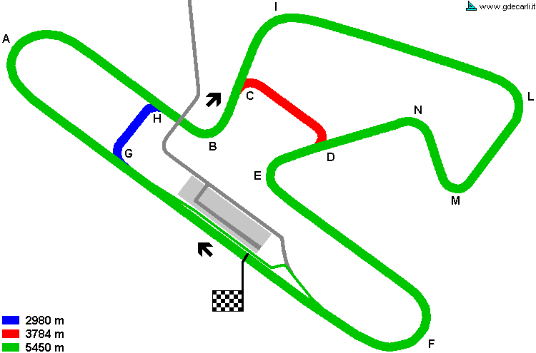
| length | 5450 m | 17881 ft | 3.387 mi | Later extension | (2) |
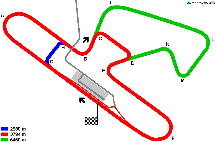
| length | 3784 m | 12415 ft | 2.351 mi | Main Course | (2) |
| Min width | 10 m | 33 ft | |||
| Max width | 12 m | 39 ft | (2) | ||
| Straight length | 1200 m | 3937 ft | 0.746 mi | Start finish straight | (2) |
| Bend minimum radius | 50 m | 164 ft | (2) | ||
| Max minimum radius | 100 m | 328 ft | (2) | ||
| Total area | 200 hectares | 2000000 m² | 494.205 acres | (2) | |
| Average Speed | 160 km/h | 99.422 mph | Short circuit | (2) | |
| Average Speed | 185 km/h | 114.957 mph | Main Course | (2) | |
Balneario de Ventanilla, short course
| Updates | |||||||
| Date | Track layout | Years | Description by | Map by | Thanks to | Note | |
| May 8th 2005 | Guido de Carli | Guido de Carli | New | Description with map | |||
| Not all eventual updates issued in last years are already visible in this list | |||||||


