| ITA - ITALY | |||||
| LUCCA | |||||
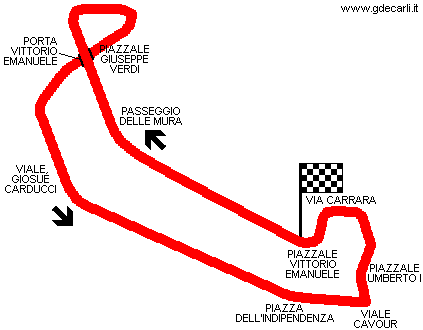
| Description | Street circuit used from 1935 to 1938 for Coppa Edda Ciano (Edda Ciano Cup). I don’t know if circuit used in 1954 was the same. | ||||
| Location | Lucca LU - Lucca - Toscana | ||||
| Location | On town wall. Porta Vittorio Emanuele has been renamed Porta S.Anna (Porta = Gate) | ||||
| Latitude - Longitude | + 43°50'19" + 10°30'04" 43.838611 10.501111 | ||||
| UTM Coordinates | X = 620676.572 - Y = 4855043.027 - Zone 32T | ||||
| Aerial photo / Map (*) |  OpenStreetMap - Google Maps - Bing Maps - Flash Earth - Wikimapia OpenStreetMap - Google Maps - Bing Maps - Flash Earth - Wikimapia | ||||
| Altitude AMSL | |||||
| Inauguration | 1935 | ||||
| Closing | |||||
| Designer | |||||
| Sources and links (Translation) (**) |
| ||||
| Circuito delle Mura | |||||
| Description | |||||
| Years | 1935÷1938, 1954 | ||||
| Direction |  Clockwise Clockwise | ||||
 Proposal Proposal |
NO | ||||
| No longer operational | YES | ||||
| Car Circuit | YES | ||||
| Motorbike circuit | |||||
| Type | Street course | ||||
| Inauguration | |||||
| Closing | |||||
| Last update of this page | April 4th 2006 | ||||
| Info last update | |||||
| Designer | |||||
| Distinctive points | |||||
| length | 2350 m | 7710 ft | 1.46 mi | ||
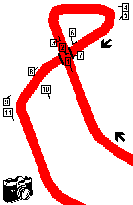
Lucca, Circuito delle Mura

| PHOTOS |
| Photos by Guido de Carli - November 1st 2004 |
| Click on thumbnail to open original large photo |
| 1 | 2 | 3 | 4 |
 |  |  |  |
| Passeggio delle Mura (Wall path), the road over town wall, in opposite direction. Photo taken above Porta (= Gate) Vittorio Emanuele | Piazzale (= Square) Verdi, taken from Paseggio delle Mura above Porta (= Gate) Vittorio Emanuele (see photo #6) | Passeggio delle Mura (Wall path), the road over town wall. Photo taken more or less in the same position where two previous photos have been taken | Downhill road that links Town Wall and Piazzale Verdi |
| 5 | 6 | 7 | 8 |
 |  |  |  |
| Piazzale Verdi and Porta Vittorio Emanuele. Photo taken in the same position where the previous one has been taken: the half man on the right with a white bag can be seen also on the left of previous pic. | Same road shown on previous pic; photo taken in opposite direction close to Porta Vittorio Emanuele (see photo #2) | Porta Vittorio Emanuele: inside | Porta Vittorio Emanuele: external side |
| 9 | 10 | 11 | |
 |  |  | |
| Porta Vittorio Emanuele: external side | Town Wall, with Baluardo S.Paolino | Viale Giosué Carducci |
| Updates | |||||||
| Date | Track layout | Years | Description by | Map by | Thanks to | Note | |
| November 2nd 2004 | Guido de Carli | New | Photos (on this site) | ||||
| January 25th 2004 | Guido de Carli | Guido de Carli | New | Description with map | |||
| Not all eventual updates issued in last years are already visible in this list | |||||||


