| ARG - ARGENTINA | |||||||||||||||||||||||||
| ZAPALA, ARTURO KRUUSE | |||||||||||||||||||||||||
| Description | Circuit used for Vuelta de Zapala, a Turismo Carettera (Argentinian Touring Car Championship) event | ||||||||||||||||||||||||
| Location | Zapala Q - Neuquén - Patagonia | ||||||||||||||||||||||||
| Location | |||||||||||||||||||||||||
| Latitude - Longitude | - 38°53'20" - 70°03'06" -38.888889 -70.051667 | ||||||||||||||||||||||||
| UTM Coordinates | X = 408790.958 - Y = 5695027.848 - Zone 19H | ||||||||||||||||||||||||
| Aerial photo / Map (*) |  OpenStreetMap - Google Maps - Bing Maps - Flash Earth - Wikimapia OpenStreetMap - Google Maps - Bing Maps - Flash Earth - Wikimapia | ||||||||||||||||||||||||
| Altitude AMSL | 1023 m - 3356 ft | ||||||||||||||||||||||||
| Inauguration | November 28th 1971 | ||||||||||||||||||||||||
| Closing | December 17th 1972 | ||||||||||||||||||||||||
| Designer | |||||||||||||||||||||||||
| Sources and links (Translation) (**) |
| ||||||||||||||||||||||||
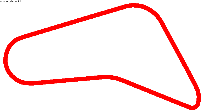
| Circuito Arturo Kruuse | |||||
| Description | Track layout drawn on aerial photo could be approximated | ||||
| Years | 1971÷1972 | ||||
| Direction | |||||
 Proposal Proposal |
NO | ||||
| No longer operational | YES | ||||
| Car Circuit | YES | ||||
| Motorbike circuit | |||||
| Type | Street course | ||||
| Inauguration | November 28th 1971 | ||||
| Closing | December 17th 1972 | ||||
| Last update of this page | April 5th 2011 | ||||
| Info last update | |||||
| Designer | |||||
| Distinctive points | Ruta Nacional Nº 40 (Cristóbal Colón) - Rotonda Primeros Pobladores - Ruta Nacional Nº 22 (Bernardo Houssay) - Avenida Alfredo Fortabat | ||||
| length | 7628 m | 25026 ft | 4.74 mi | (3) | |
| length | 7197 m | 23611 ft | 4.472 mi | Calculated from aerial photo (*) | (5) |
Zapala - Circuito Arturo Kruuse
Due to technical problems, temporarily it’s no longer possible to see the circuits on Google Maps embedded in the current page.
This feature will be restored as soon as I figure out how to do (any help would be appreciated!)
See this track layout with Google Earth
- milermeter.com
(milermeter.com can be used in your browser, without installing anything; Google Earth is a program that must be installed in your computer)
(Map shown here above can show at the same time all eventual layouts drawn. If you want to see only some of them, please go to Google Maps or Google Earth, by clicking on its own link)
| Updates | |||||||
| Date | Track layout | Years | Description by | Map by | Thanks to | Note | |
| April 5th 2011 | Circuito Arturo Kruuse | 1971÷1972 | Guido de Carli | Guido de Carli | Luis Alberto González | New | Description with map |
| Not all eventual updates issued in last years are already visible in this list | |||||||


