| GBR - UNITED KINGDOM | |||||||||||||||||||||||||||||||||||||||||||||||||||||||||||||||||||||||||
| OULTON PARK | |||||||||||||||||||||||||||||||||||||||||||||||||||||||||||||||||||||||||
| Description | Circuit opened in 1953; in 1970s it hosted important car (up to Formula 2) and motorbike races. Then it become less important: at the end of 1970s it hosted only national car races on short circuit or motorbike races (even International) on the long circuit, not shown on my map. Because of managing problems, in 1979 according to rumors it could have been closed. | ||||||||||||||||||||||||||||||||||||||||||||||||||||||||||||||||||||||||
| Location | Little Budworth CHS - Cheshire - England | ||||||||||||||||||||||||||||||||||||||||||||||||||||||||||||||||||||||||
| Location | Not far from Chester, Liverpool and Manchester; Central England | ||||||||||||||||||||||||||||||||||||||||||||||||||||||||||||||||||||||||
| Latitude - Longitude | + 53°10'37" - 2°37'05" 53.176944 -2.618056 | ||||||||||||||||||||||||||||||||||||||||||||||||||||||||||||||||||||||||
| UTM Coordinates | X = 525527.435 - Y = 5892022.494 - Zone 30U | ||||||||||||||||||||||||||||||||||||||||||||||||||||||||||||||||||||||||
| Aerial photo / Map (*) |  OpenStreetMap - Google Maps - Bing Maps - Flash Earth - Wikimapia OpenStreetMap - Google Maps - Bing Maps - Flash Earth - Wikimapia | ||||||||||||||||||||||||||||||||||||||||||||||||||||||||||||||||||||||||
| Altitude AMSL | 67 m - 220 ft | ||||||||||||||||||||||||||||||||||||||||||||||||||||||||||||||||||||||||
| Inauguration | 1953 | ||||||||||||||||||||||||||||||||||||||||||||||||||||||||||||||||||||||||
| Closing | |||||||||||||||||||||||||||||||||||||||||||||||||||||||||||||||||||||||||
| Designer | |||||||||||||||||||||||||||||||||||||||||||||||||||||||||||||||||||||||||
| Sources and links (Translation) (**) |
| ||||||||||||||||||||||||||||||||||||||||||||||||||||||||||||||||||||||||
| Oulton Park | |||||
| Description | |||||
| Years | 1953 | ||||
| Direction |  Clockwise Clockwise | ||||
 Proposal Proposal |
NO | ||||
| No longer operational | YES | ||||
| Car Circuit | |||||
| Motorbike circuit | |||||
| Type | Permanent | ||||
| Inauguration | 1953 | ||||
| Closing | 1953 | ||||
| Last update of this page | January 10th 2008 | ||||
| Info last update | |||||
| Designer | |||||
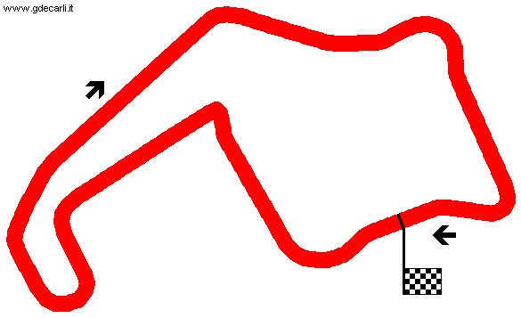
| Distinctive points | Old Hall corner - The Avenue - Cascades - Range - Clay Hill - Water Tower - Druids Corner - Lodge Corner - Deer Leap | ||||
| length | 2414 m | 7920 ft | 1.5 mi | (7) | |
| Oulton Park | |||||
| Description | My map is quite different from ones shown by different sources, it could be approximated. | ||||
| Years | 1954÷1972 | ||||
| Direction | Clockwise | ||||
| Proposal |
NO | ||||
| No longer operational | YES | ||||
| Car Circuit | YES | ||||
| Motorbike circuit | YES | ||||
| Type | Permanent | ||||
| Inauguration | 1954 | ||||
| Closing | 1972 | ||||
| Last update of this page | January 10th 2008 | ||||
| Info last update | |||||
| Designer | |||||
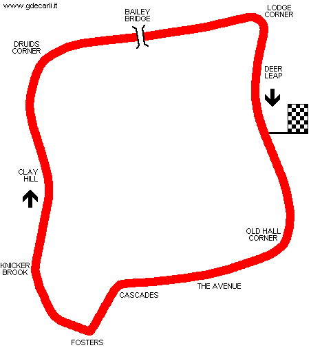
| Distinctive points | Old Hall corner - The Avenue - Dentons - Cascades - Lakeside - Island - Esso - Hill Top - Knicker Brook - Clay Hill - Water Tower - Druids Corner - Lodge Corner - Deer Leap | ||||
| length | 4443 m | 14578 ft | 2.761 mi | Full circuit | (7) |
| length | 4426 m | 14521 ft | 2.75 mi | Full circuit | (1) |
| length | 3792 m | 12439 ft | 2.356 mi | Island Circuit (medium course) | (7) |
| length | 2662 m | 8733 ft | 1.654 mi | Fosters Circuit (short course) | (7) |
| Min width | 9.1 m | 30 ft | (1) | ||
| Oulton Park | |||||
| Description | |||||
| Years | 1973÷1991 | ||||
| Direction | Clockwise | ||||
| Proposal |
NO | ||||
| No longer operational | YES | ||||
| Car Circuit | YES | ||||
| Motorbike circuit | YES | ||||
| Type | Permanent | ||||
| Inauguration | 1973 | ||||
| Closing | 1991 | ||||
| Last update of this page | January 10th 2008 | ||||
| Info last update | |||||
| Designer | |||||
| Distinctive points | Old Hall corner - The Avenue - Dentons - Cascades - Lakeside - Island - Shell - Foulston’s - Hill Top - Knicker Brook - Clay Hill - Water Tower - Druids Corner - Lodge Corner - Deer Leap | ||||
| length | 4456 m | 14620 ft | 2.769 mi | Full circuit | (7) |
| length | 3792 m | 12439 ft | 2.356 mi | Island Circuit (medium course) | (7) |
| length | 2662 m | 8733 ft | 1.654 mi | Fosters Circuit (short course) | (7) |
| length | 2606 m | 8550 ft | 1.619 mi | Fosters Circuit (short course) | (15) |
| Oulton Park | |||||
| Description | |||||
| Years | 1992÷2002 | ||||
| Direction | Clockwise | ||||
| Proposal |
NO | ||||
| No longer operational | YES | ||||
| Car Circuit | YES | ||||
| Motorbike circuit | YES | ||||
| Type | Permanent | ||||
| Inauguration | 1992 | ||||
| Closing | 2002 | ||||
| Last update of this page | January 10th 2008 | ||||
| Info last update | |||||
| Designer | |||||
| Distinctive points | Old Hall corner - The Avenue - Dentons - Cascades - Lakeside - Island - Shell - Foulston’s - Hill Top - Knicker Brook - Clay Hill - Water Tower - Druids Corner - Lodge Corner - Deer Leap | ||||
| length | 4466 m | 14652 ft | 2.775 mi | Full circuit | (7) |
| length | 3801 m | 12471 ft | 2.362 mi | Island Circuit (medium course) | (7) |
| length | 2662 m | 8733 ft | 1.654 mi | Fosters Circuit (short course) | (7) |
| Oulton Park | |||||
| Description | |||||
| Years | 2003÷... | ||||
| Direction | Clockwise | ||||
| Proposal |
NO | ||||
| No longer operational | |||||
| Car Circuit | YES | ||||
| Motorbike circuit | YES | ||||
| Type | Permanent | ||||
| Inauguration | 2003 | ||||
| Closing | |||||
| Last update of this page | November 11th 2008 | ||||
| Info last update | |||||
| Designer | |||||
| Distinctive points | Old Hall corner - The Avenue - Dentons - Cascades - Lakeside - Island - Shell - Foulston’s - Hill Top - Hizzy’s - Knicker Brook - Clay Hill - Water Tower - Druids Corner - Lodge Corner - Deer Leap | ||||
| length | 4332 m | 14213 ft | 2.692 mi | Full circuit | (7) |
| length | 4332 m | 14213 ft | 2.692 mi | Full circuit | (17) |
| length | 3637 m | 11932 ft | 2.26 mi | Island Circuit (medium course) | (17) |
| length | 2662 m | 8733 ft | 1.654 mi | Fosters Circuit (short course) | (7) |
| length | 2671 m | 8765 ft | 1.66 mi | Fosters Circuit (short course) | (17) |
Oulton Park 1954÷1972 (approximated map?)
Oulton Park Fosters Circuit (short course)
| Updates | |||||||
| Date | Track layout | Years | Description by | Map by | Thanks to | Note | |
| January 9th 2010 | Guido de Carli | andylaurence | Update | Description without map | |||
| November 11th 2008 | 2003÷... | Guido de Carli | Update | Description | |||
| October 2nd 2008 | Guido de Carli | Update | Description | ||||
| January 10th 2008 | Guido de Carli | Update | Description | ||||
| November 26th 2004 | 1954÷1972 | Guido de Carli | Guido de Carli | New | Description with map | ||
| November 26th 2004 | 1973÷1991 | Guido de Carli | Guido de Carli | New | Description with map | ||
| Not all eventual updates issued in last years are already visible in this list | |||||||


