| MKD - MACEDONIA | |||||
| GEVGELIJA / ГЕВГЕЛИЈА | |||||
| Description | This track has been used twice for Macedonian Touring Car Championship | ||||
| Location | Gevgelija - Sudorientale / Southeastern / Југоисточен | ||||
| Location | |||||
| Latitude - Longitude (approx) | + 41°08'45" + 22°31'00" (approx) 41.145833 22.516667 (approx) | ||||
| UTM Coordinates (approx) | X = 627274.484 - Y = 4556054.637 - Zone 34T (approx) | ||||
| Aerial photo / Map (*) |  OpenStreetMap - Google Maps - Bing Maps - Flash Earth - Wikimapia OpenStreetMap - Google Maps - Bing Maps - Flash Earth - Wikimapia | ||||
| Altitude AMSL (approx) | 50 m - 164 ft (approx) | ||||
| Inauguration | 1996 | ||||
| Closing | 2001 | ||||
| Designer | |||||
| Sources and links (Translation) (**) |
| ||||
| Gevgelija / Гевгелија | |||||
| Description | |||||
| Years | |||||
| Direction |  Clockwise Clockwise | ||||
 Proposal Proposal |
NO | ||||
| No longer operational | YES | ||||
| Car Circuit | YES | ||||
| Motorbike circuit | |||||
| Type | Street course | ||||
| Inauguration | 1996 | ||||
| Closing | 2001 | ||||
| Last update of this page | October 28th 2007 | ||||
| Info last update | |||||
| Designer | |||||
| Distinctive points | |||||
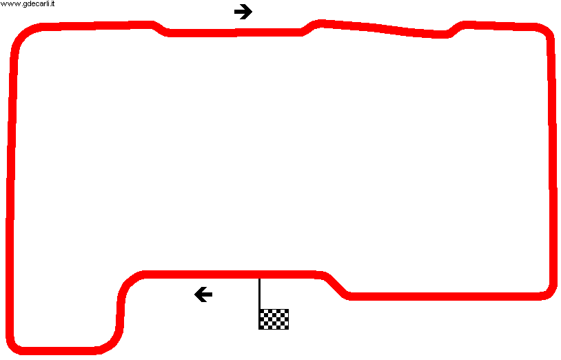
| length | 2430 m | 7972 ft | 1.51 mi | (1) | |
Gevgelija
| Updates | |||||||
| Date | Track layout | Years | Description by | Map by | Thanks to | Note | |
| November 21st 2007 | Lorenzo Tommasi | Katz | Update | Description with map | |||
| October 28th 2007 | Lorenzo Tommasi | Katz | New | Description without map | |||
| Not all eventual updates issued in last years are already visible in this list | |||||||


