ARG - ARGENTINA
BUENOS AIRES, COSTANERA
Not to be confused with Buenos Aires (D3) - Buenos Aires, Autódromo Oscar y Juan Gálvez - Buenos Aires, Avd. 9 de Julio (TC 2012) - Buenos Aires, Hipódromo (1901) - Buenos Aires, Palermo - Buenos Aires, Palermo (1994) - Buenos Aires, Recoleta (TC 2013) - Buenos Aires, Retiro - Recoleta - Palermo - Tigre
Description 
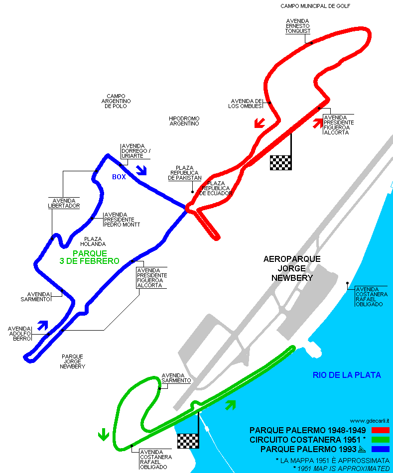
Costanera circuit, used in 1950s, was very close to Palermo Circuit; layout shown on the map was used in 1951. 1957 layout was longer, but it is not drawn on the map. The latter is approximated because some roads changed since 1950s.
Location Buenos Aires
C - Ciudad de Buenos Aires - Buenos Aires
Location Between Jorge Newbery airport and Rio de la Plata
Latitude - Longitude - 34°33'45"     - 58°24'22"
-34.5625     -58.406111
UTM Coordinates X = 371006.206  -  Y = 6174574.216  -  Zone 21H
Aerial photo / Map (*) Aerial photo / Map (*) OpenStreetMap  -   Aerial photo / Map (*) Google Maps  -   Aerial photo / Map (*) Bing Maps  -   Aerial photo / Map (*) Flash Earth  -   Aerial photo / Map (*) Wikimapia
Altitude AMSL 2 m - 7 ft
Inauguration February 18th 1951
Closing January 20th 1957
Designer  
Sources and links (Translation) (**)
(1) Angola www.jmfangio.org/gp1951baires.htmUn tributo al Chueco (a tribute to Fangio’s career): map (to be confirmed) and description of 1951 race
(2) Angola www.jmfangio.org/gp1957baires1k.htmUn tributo al Chueco (a tribute to Fangio’s career): map (to be confirmed) and description of 1957 race

(*) NOTE: a complete and detailed view of the circuit can be found (if available) on Street View by Google Maps and/or Bird's Eye and 3D views by Bing Maps for Enterprise (former Microsoft Virtual Earth): both can be reached using their own link in Aerial photo / Map cell.

(**) For on-line not-English speaking sources, click on each small flag and you open the corresponding Google Translator page with automatic translation.

Buenos Aires, Costanera
Description  
Years 1951
Direction Anticlockwise   Anticlockwise
Progetto Proposal NO
No longer operational YES
Car Circuit YES
Motorbike circuit  
Type Street course
Inauguration February 18th 1951
Closing February 24th 1951
Last update of this page March 24th 2007
Info last update  
Designer  
Distinctive points Avenida Costanera Rafael Obligado - Avenida Sarmiento
length 3500  m 11483  ft 2.175  mi   (1)

Buenos Aires, Costanera
Description  
Years 1957
Direction Anticlockwise   Anticlockwise
Progetto Proposal NO
No longer operational YES
Car Circuit YES
Motorbike circuit  
Type Street course
Inauguration January 20th 1957
Closing January 20th 1957
Last update of this page March 24th 2007
Info last update  
Designer  
Distinctive points Avenida Costanera Rafael Obligado - Avenida Sarmiento
length 10219  m 33527  ft 6.35  mi   (2)

Green: Circuito Costanera 1951 (approximated)

Green: Circuito Costanera 1951 (approximated)


Updates
Date Track layout Years Description by Map by Thanks to Note
March 24th 2007     Guido de Carli        
November 18th 2005   1951 Guido de Carli   Barry Boor Update Description
March 11th 2004     Guido de Carli     Update Description with map
July 23rd 2003     Guido de Carli     Update Description
Not all eventual updates issued in last years are already visible in this list
 
Webmaster:
Guido de Carli
(Italiano - English - Español)
Home Page HOME PAGE
DISCLAIMER (in Italian)