| FRA - FRANCE | |||||||||||||||||||||||||||||||||||||||||||||||||||||||||||||||||||||||||||||||||||||||||||||||||||||||||||||||||||||||||||||||||||||||||||||||||||||||||||||||||||||||||||||||||||||||||||||||||||||||||||||
| LE MANS, SARTHE & BUGATTI | |||||||||||||||||||||||||||||||||||||||||||||||||||||||||||||||||||||||||||||||||||||||||||||||||||||||||||||||||||||||||||||||||||||||||||||||||||||||||||||||||||||||||||||||||||||||||||||||||||||||||||||
| SORRY, SOME DATA ARE NOT TRANSLATED YET | |||||||||||||||||||||||||||||||||||||||||||||||||||||||||||||||||||||||||||||||||||||||||||||||||||||||||||||||||||||||||||||||||||||||||||||||||||||||||||||||||||||||||||||||||||||||||||||||||||||||||||||
| Not to be confused with | Le Mans (1911÷1913) - Le Mans - Connerré - Le Mans, Maison Blanche (kart) | ||||||||||||||||||||||||||||||||||||||||||||||||||||||||||||||||||||||||||||||||||||||||||||||||||||||||||||||||||||||||||||||||||||||||||||||||||||||||||||||||||||||||||||||||||||||||||||||||||||||||||||
| Description | |||||||||||||||||||||||||||||||||||||||||||||||||||||||||||||||||||||||||||||||||||||||||||||||||||||||||||||||||||||||||||||||||||||||||||||||||||||||||||||||||||||||||||||||||||||||||||||||||||||||||||||
| Location | Le Mans 72 - Sarthe - Pays de la Loire | ||||||||||||||||||||||||||||||||||||||||||||||||||||||||||||||||||||||||||||||||||||||||||||||||||||||||||||||||||||||||||||||||||||||||||||||||||||||||||||||||||||||||||||||||||||||||||||||||||||||||||||
| Location | |||||||||||||||||||||||||||||||||||||||||||||||||||||||||||||||||||||||||||||||||||||||||||||||||||||||||||||||||||||||||||||||||||||||||||||||||||||||||||||||||||||||||||||||||||||||||||||||||||||||||||||
| Latitude - Longitude | + 47°56'29" + 0°12'57" 47.941389 0.215833 | ||||||||||||||||||||||||||||||||||||||||||||||||||||||||||||||||||||||||||||||||||||||||||||||||||||||||||||||||||||||||||||||||||||||||||||||||||||||||||||||||||||||||||||||||||||||||||||||||||||||||||||
| UTM Coordinates | X = 292086.833 - Y = 5313537.87 - Zone 31T | ||||||||||||||||||||||||||||||||||||||||||||||||||||||||||||||||||||||||||||||||||||||||||||||||||||||||||||||||||||||||||||||||||||||||||||||||||||||||||||||||||||||||||||||||||||||||||||||||||||||||||||
| Aerial photo / Map (*) |  OpenStreetMap - Google Maps - Bing Maps - Flash Earth - Wikimapia - GéoPortail OpenStreetMap - Google Maps - Bing Maps - Flash Earth - Wikimapia - GéoPortail | ||||||||||||||||||||||||||||||||||||||||||||||||||||||||||||||||||||||||||||||||||||||||||||||||||||||||||||||||||||||||||||||||||||||||||||||||||||||||||||||||||||||||||||||||||||||||||||||||||||||||||||
| Altitude AMSL | 44 m - 144 ft | ||||||||||||||||||||||||||||||||||||||||||||||||||||||||||||||||||||||||||||||||||||||||||||||||||||||||||||||||||||||||||||||||||||||||||||||||||||||||||||||||||||||||||||||||||||||||||||||||||||||||||||
| Inauguration | 1920 | ||||||||||||||||||||||||||||||||||||||||||||||||||||||||||||||||||||||||||||||||||||||||||||||||||||||||||||||||||||||||||||||||||||||||||||||||||||||||||||||||||||||||||||||||||||||||||||||||||||||||||||
| Closing | |||||||||||||||||||||||||||||||||||||||||||||||||||||||||||||||||||||||||||||||||||||||||||||||||||||||||||||||||||||||||||||||||||||||||||||||||||||||||||||||||||||||||||||||||||||||||||||||||||||||||||||
| Designer | |||||||||||||||||||||||||||||||||||||||||||||||||||||||||||||||||||||||||||||||||||||||||||||||||||||||||||||||||||||||||||||||||||||||||||||||||||||||||||||||||||||||||||||||||||||||||||||||||||||||||||||
| Sources and links (Translation) (**) |
| ||||||||||||||||||||||||||||||||||||||||||||||||||||||||||||||||||||||||||||||||||||||||||||||||||||||||||||||||||||||||||||||||||||||||||||||||||||||||||||||||||||||||||||||||||||||||||||||||||||||||||||
| Circuit de la Sarthe | |||||
| Description | |||||
| Years | 1920÷1928 | ||||
| Direction |  Clockwise Clockwise | ||||
 Proposal Proposal |
NO | ||||
| No longer operational | YES | ||||
| Car Circuit | YES | ||||
| Motorbike circuit | |||||
| Type | Road course | ||||
| Inauguration | 1920 | ||||
| Closing | 1928 | ||||
| Last update of this page | January 25th 2009 | ||||
| Info last update | |||||
| Designer | |||||
| Distinctive points | |||||
| length | 17220 m | 56494 ft | 10.7 mi | (16) | |
| length | 17100 m | 56102 ft | 10.626 mi | (6) | |
| length | 17100 m | 56102 ft | 10.626 mi | (9) | |
| length | 17260 m | 56627 ft | 10.725 mi | (10) | |
| length | 17261 m | 56631 ft | 10.726 mi | (20) | |
| length | 17261 m | 56631 ft | 10.726 mi | (15) | |
| length | 17262 m | 56634 ft | 10.726 mi | (12) | |
| length | 17262 m | 56634 ft | 10.726 mi | (19) | |
| length | 17262 m | 56634 ft | 10.726 mi | (7) | |
| length | 17262 m | 56634 ft | 10.726 mi | (8) | |
| Grand Prix de l’U.M.F. cyclecars | |||||
| Description | Layout used for 1922 Grand Prix de l’U.M.F. cyclecars. I don’t know if it had been used again nor I have more details about track layout | ||||
| Years | 1922 | ||||
| Direction | |||||
| Proposal |
NO | ||||
| No longer operational | YES | ||||
| Car Circuit | |||||
| Motorbike circuit | YES | ||||
| Type | Road course | ||||
| Inauguration | September 16th 1922 | ||||
| Closing | September 16th 1922 | ||||
| Last update of this page | January 25th 2009 | ||||
| Info last update | |||||
| Designer | |||||
| Distinctive points | |||||
| length | 22057 m | 72365 ft | 13.706 mi | (11) | |
| Circuit de la Sarthe | |||||
| Description | |||||
| Years | 1929÷1931 | ||||
| Direction | Clockwise | ||||
| Proposal |
NO | ||||
| No longer operational | YES | ||||
| Car Circuit | YES | ||||
| Motorbike circuit | |||||
| Type | Road course | ||||
| Inauguration | 1929 | ||||
| Closing | 1931 | ||||
| Last update of this page | January 25th 2009 | ||||
| Info last update | |||||
| Designer | |||||
| Distinctive points | |||||
| length | 16340 m | 53609 ft | 10.153 mi | (19) | |
| length | 16918 m | 55505 ft | 10.513 mi | (20) | |
| Circuit de la Sarthe | |||||
| Description | |||||
| Years | 1932÷1955 | ||||
| Direction | Clockwise | ||||
| Proposal |
NO | ||||
| No longer operational | YES | ||||
| Car Circuit | YES | ||||
| Motorbike circuit | |||||
| Type | Road course | ||||
| Inauguration | 1932 | ||||
| Closing | 1955 | ||||
| Last update of this page | January 25th 2009 | ||||
| Info last update | |||||
| Designer | |||||
| Distinctive points | |||||
| length | 13483 m | 44235 ft | 8.378 mi | (20) | |
| length | 13492 m | 44265 ft | 8.384 mi | (19) | |
| Circuit de la Sarthe | |||||
| Description | |||||
| Years | 1956÷1967 | ||||
| Direction | Clockwise | ||||
| Proposal |
NO | ||||
| No longer operational | YES | ||||
| Car Circuit | YES | ||||
| Motorbike circuit | |||||
| Type | Road course | ||||
| Inauguration | 1956 | ||||
| Closing | 1967 | ||||
| Last update of this page | January 25th 2009 | ||||
| Info last update | |||||
| Designer | |||||
| Distinctive points | |||||
| length | 13483 m | 44235 ft | 8.378 mi | (20) | |
| length | 13461 m | 44163 ft | 8.365 mi | (19) | |
| Circuit de la Sarthe | |||||
| Description | |||||
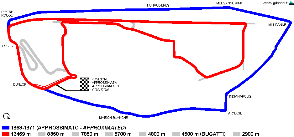
| Years | 1968÷1971 | ||||
| Direction | Clockwise | ||||
| Proposal |
NO | ||||
| No longer operational | YES | ||||
| Car Circuit | YES | ||||
| Motorbike circuit | |||||
| Type | Road course | ||||
| Inauguration | 1968 | ||||
| Closing | 1971 | ||||
| Last update of this page | January 25th 2009 | ||||
| Info last update | |||||
| Designer | |||||
| Distinctive points | |||||
| length | 13468 m | 44186 ft | 8.369 mi | (20) | |
| length | 13469 m | 44190 ft | 8.369 mi | (19) | |
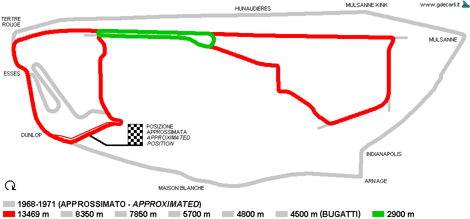
| Circuit de la Sarthe | |||||
| Description | In winter 1968/1969 CREM was founded: it was a committee for study any possible changes to the traditional circuit. In June 1969 it proposed this project: there should have been a new circuit for future 24 hours, oddly exactly as long as the old one, and 6 more minor courses. I don’t know if the goal was to transform it into a permanent circuit (as the goal from 1971) or if it was safety or both. | ||||
| Years | 1969 | ||||
| Direction | Clockwise | ||||
| Proposal |
YES
| ||||
| Proposal not developed | YES | ||||
| Car Circuit | YES | ||||
| Motorbike circuit | |||||
| Type | Permanent | ||||
| Inauguration | |||||
| Closing | |||||
| Last update of this page | January 25th 2009 | ||||
| Info last update | |||||
| Designer | |||||
| Distinctive points | |||||
| length | 2900 m | 9514 ft | 1.802 mi | (33) | |
| length | 4800 m | 15748 ft | 2.983 mi | (33) | |
| length | 5700 m | 18701 ft | 3.542 mi | (33) | |
| length | 7850 m | 25755 ft | 4.878 mi | (33) | |
| length | 8350 m | 27395 ft | 5.189 mi | (33) | |
| length | 13469 m | 44190 ft | 8.369 mi | Full circuit | (33) |
| length | 4500 m | 14764 ft | 2.796 mi | Circuit Bugatti | (33) |
| Circuit de la Sarthe | |||||
| Description | |||||
| Years | 1972÷1978 | ||||
| Direction | Clockwise | ||||
| Proposal |
NO | ||||
| No longer operational | YES | ||||
| Car Circuit | YES | ||||
| Motorbike circuit | |||||
| Type | Road course | ||||
| Inauguration | 1972 | ||||
| Closing | 1978 | ||||
| Last update of this page | January 25th 2009 | ||||
| Info last update | |||||
| Designer | |||||
| Distinctive points | |||||
| length | 13640 m | 44751 ft | 8.476 mi | (19) | |
| length | 13640 m | 44751 ft | 8.476 mi | (20) | |
| Circuit de la Sarthe | |||||
| Description | |||||
| Years | 1972 | ||||
| Direction | Clockwise | ||||
| Proposal |
YES
| ||||
| Proposal not developed | YES | ||||
| Car Circuit | YES | ||||
| Motorbike circuit | |||||
| Type | |||||
| Inauguration | |||||
| Closing | |||||
| Last update of this page | January 25th 2009 | ||||
| Info last update | |||||
| Designer | |||||
| Distinctive points | |||||
| length | 13664 m | 44829 ft | 8.491 mi | (36) | |
| Circuit de la Sarthe | |||||
| Description | |||||
| Years | 1974 | ||||
| Direction | Clockwise | ||||
| Proposal |
YES
| ||||
| Proposal not developed | YES | ||||
| Car Circuit | YES | ||||
| Motorbike circuit | |||||
| Type | |||||
| Inauguration | |||||
| Closing | |||||
| Last update of this page | January 25th 2009 | ||||
| Info last update | |||||
| Designer | |||||
| Distinctive points | |||||
| length | 12620 m | 41404 ft | 7.842 mi | (36) | |
| Circuit de la Sarthe | |||||
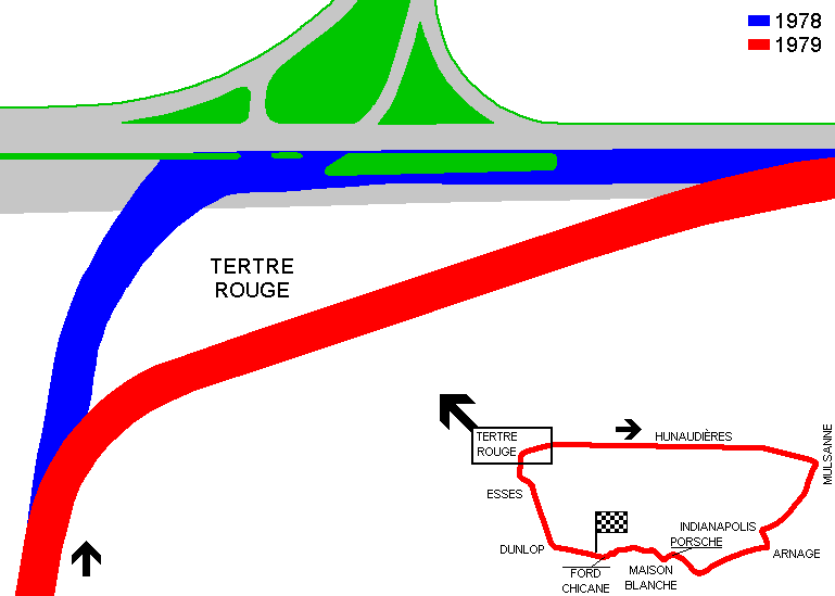
| Description | In 1979 some changes were made to the classical circuit. The only one that changed track layout was at Tertre Rouge, because of new motorway entry. After this change, the circuit was 14 meters shorter. | ||||
| Years | 1979÷1985 | ||||
| Direction | Clockwise | ||||
| Proposal |
NO | ||||
| No longer operational | YES | ||||
| Car Circuit | YES | ||||
| Motorbike circuit | |||||
| Type | Road course | ||||
| Inauguration | 1979 | ||||
| Closing | 1985 | ||||
| Last update of this page | January 25th 2009 | ||||
| Info last update | |||||
| Designer | |||||
| Distinctive points | |||||
| length | 13626 m | 44705 ft | 8.467 mi | (19) | |
| length | 13626 m | 44705 ft | 8.467 mi | (20) | |
| length | 13626.5 m | 44706 ft | 8.467 mi | (39) | |
| Circuit de la Sarthe | |||||
| Description | |||||
| Years | 1986 | ||||
| Direction | Clockwise | ||||
| Proposal |
NO | ||||
| No longer operational | YES | ||||
| Car Circuit | YES | ||||
| Motorbike circuit | |||||
| Type | Road course | ||||
| Inauguration | 1986 | ||||
| Closing | June 1986 | ||||
| Last update of this page | January 25th 2009 | ||||
| Info last update | |||||
| Designer | |||||
| Distinctive points | |||||
| length | 13528 m | 44383 ft | 8.406 mi | (19) | |
| length | 13626 m | 44705 ft | 8.467 mi | (20) | |
| Circuit de la Sarthe | |||||
| Description | |||||
| Years | 1987÷1989 | ||||
| Direction | Clockwise | ||||
| Proposal |
NO | ||||
| No longer operational | YES | ||||
| Car Circuit | YES | ||||
| Motorbike circuit | |||||
| Type | Road course | ||||
| Inauguration | |||||
| Closing | |||||
| Last update of this page | January 25th 2009 | ||||
| Info last update | |||||
| Designer | |||||
| Distinctive points | |||||
| length | 13534 m | 44403 ft | 8.41 mi | (20) | |
| length | 13535 m | 44406 ft | 8.41 mi | (19) | |
| Circuit de la Sarthe | |||||
| Description | |||||
| Years | 1990÷1996 | ||||
| Direction | Clockwise | ||||
| Proposal |
NO | ||||
| No longer operational | YES | ||||
| Car Circuit | YES | ||||
| Motorbike circuit | |||||
| Type | Road course | ||||
| Inauguration | 1990 | ||||
| Closing | 1996 | ||||
| Last update of this page | January 25th 2009 | ||||
| Info last update | |||||
| Designer | |||||
| Distinctive points | |||||
| length | 13600 m | 44619 ft | 8.451 mi | (19) | |
| length | 13600 m | 44619 ft | 8.451 mi | (20) | |
| Circuit de la Sarthe | |||||
| Description | |||||
| Years | 1997÷2001 | ||||
| Direction | Clockwise | ||||
| Proposal |
NO | ||||
| No longer operational | YES | ||||
| Car Circuit | YES | ||||
| Motorbike circuit | |||||
| Type | Road course | ||||
| Inauguration | 1997 | ||||
| Closing | 2001 | ||||
| Last update of this page | January 25th 2009 | ||||
| Info last update | |||||
| Designer | |||||
| Distinctive points | |||||
| length | 13600 m | 44619 ft | 8.451 mi | (20) | |
| length | 13605 m | 44636 ft | 8.454 mi | (19) | |
| Circuit de la Sarthe | |||||
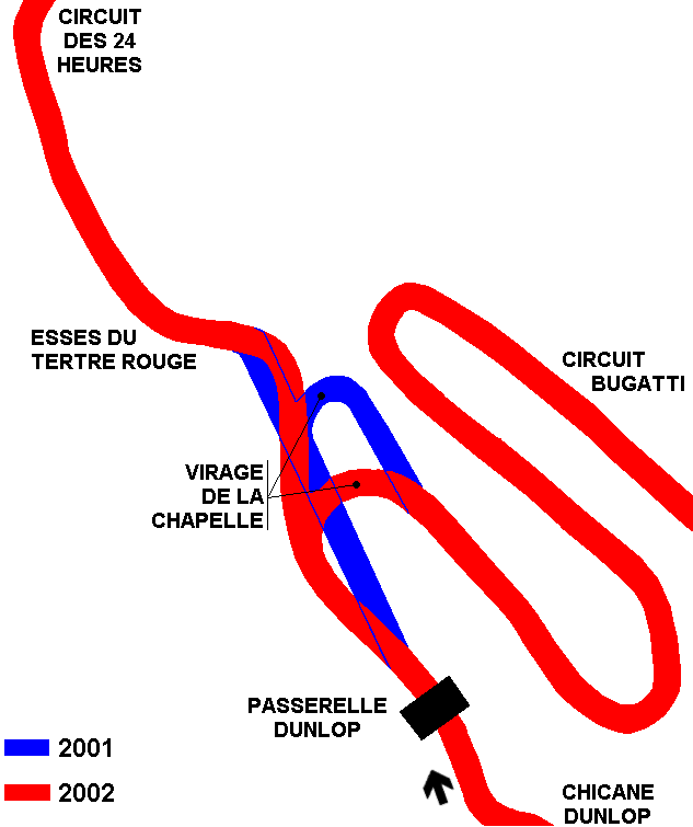
| Description | Modification made at beginning of 2002 just after start line both to 24hours and to Bugatti circuits (partial map) | ||||
| Years | 2002÷2005 | ||||
| Direction | Clockwise | ||||
| Proposal |
NO | ||||
| No longer operational | YES | ||||
| Car Circuit | YES | ||||
| Motorbike circuit | |||||
| Type | Road course | ||||
| Inauguration | 2002 | ||||
| Closing | 2005 | ||||
| Last update of this page | March 6th 2010 | ||||
| Info last update | |||||
| Designer | |||||
| Distinctive points | |||||
| length | 13650 m | 44783 ft | 8.482 mi | (19) | |
| length | 13650 m | 44783 ft | 8.482 mi | (20) | |
| length | 13880 m | 45538 ft | 8.625 mi | (45) | |
| Circuit de la Sarthe | |||||
| Description | |||||
| Years | 2006÷... | ||||
| Direction | Clockwise | ||||
| Proposal |
NO | ||||
| No longer operational | |||||
| Car Circuit | YES | ||||
| Motorbike circuit | |||||
| Type | Road course | ||||
| Inauguration | 2006 | ||||
| Closing | |||||
| Last update of this page | January 25th 2009 | ||||
| Info last update | |||||
| Designer | |||||
| Distinctive points | |||||
| Circuit Bugatti | |||||
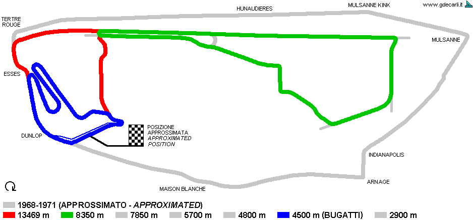
| Description | Circuit designed in 1966 by Charles de Cortanze, driver and ACO (Automobile Club de l’Ouest) member | ||||
| Years | 1966÷1986 | ||||
| Direction | Clockwise | ||||
| Proposal |
NO | ||||
| No longer operational | YES | ||||
| Car Circuit | YES | ||||
| Motorbike circuit | YES | ||||
| Type | Permanent | ||||
| Inauguration | 1966 | ||||
| Closing | 1986 | ||||
| Last update of this page | May 29th 2007 | ||||
| Info last update | |||||
| Designer | de Cortanze Charles de Cortanze | ||||
| Distinctive points | |||||
| length | 4430 m | 14534 ft | 2.753 mi | (20) | |
| Circuit Bugatti | |||||
| Description | |||||
| Years | 1987÷1995 | ||||
| Direction | Clockwise | ||||
| Proposal |
NO | ||||
| No longer operational | YES | ||||
| Car Circuit | YES | ||||
| Motorbike circuit | YES | ||||
| Type | Permanent | ||||
| Inauguration | 1987 | ||||
| Closing | 1995 | ||||
| Last update of this page | May 29th 2007 | ||||
| Info last update | |||||
| Designer | de Cortanze Charles de Cortanze | ||||
| Distinctive points | |||||
| length | 4430 m | 14534 ft | 2.753 mi | (20) | |
| Circuit Bugatti | |||||
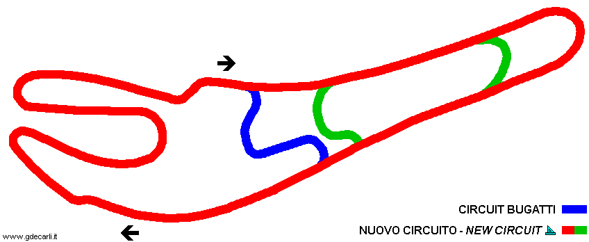
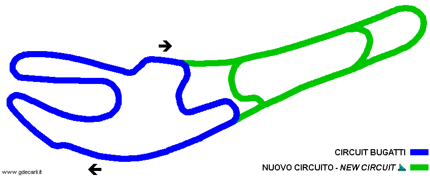
| Description | Proposal not developed, dated beginning of 1994 for lengthen Bugatti circuit and for create a new test track approx. 9.5 km long. Final target was to create an alternative to classical 24 hours track and to race a F.1 France GP. Note: Bugatti circuit on this map seems quite different from other maps, I don’t know if this difference are due to a bad original map or to some changes also in the the classical Bugatti circuit. | ||||
| Years | 1994 | ||||
| Direction | Clockwise | ||||
| Proposal |
YES
| ||||
| Proposal not developed | YES | ||||
| Car Circuit | YES | ||||
| Motorbike circuit | |||||
| Type | Permanent | ||||
| Inauguration | |||||
| Closing | |||||
| Last update of this page | November 28th 2007 | ||||
| Info last update | |||||
| Designer | |||||
| Distinctive points | |||||
| length (approx) | 9500 m | 31168 ft | 5.903 mi | Long circuit | (44) |
| Circuit Bugatti | |||||
| Description | |||||
| Years | 1996÷2001 | ||||
| Direction | Clockwise | ||||
| Proposal |
NO | ||||
| No longer operational | YES | ||||
| Car Circuit | YES | ||||
| Motorbike circuit | YES | ||||
| Type | Permanent | ||||
| Inauguration | 1996 | ||||
| Closing | 2001 | ||||
| Last update of this page | May 29th 2007 | ||||
| Info last update | |||||
| Designer | de Cortanze Charles de Cortanze | ||||
| Distinctive points | |||||
| length | 4305 m | 14124 ft | 2.675 mi | (20) | |
| Circuit Bugatti | |||||
| Description | Modification made at beginning of 2002 just after start line both to 24hours and to Bugatti circuits (partial map) | ||||
| Years | 2002÷2005 | ||||
| Direction | Clockwise | ||||
| Proposal |
NO | ||||
| No longer operational | |||||
| Car Circuit | YES | ||||
| Motorbike circuit | YES | ||||
| Type | Permanent | ||||
| Inauguration | 2002 | ||||
| Closing | 2005 | ||||
| Last update of this page | March 6th 2010 | ||||
| Info last update | |||||
| Designer | |||||
| Distinctive points | |||||
| length | 4273 m | 14019 ft | 2.655 mi | (45) | |
| length | 4430 m | 14534 ft | 2.753 mi | (20) | |
| Circuit Bugatti | |||||
| Description | |||||
| Years | 2006÷... | ||||
| Direction | Clockwise | ||||
| Proposal |
NO | ||||
| No longer operational | |||||
| Car Circuit | YES | ||||
| Motorbike circuit | YES | ||||
| Type | Permanent | ||||
| Inauguration | 2002 | ||||
| Closing | 2005 | ||||
| Last update of this page | March 6th 2010 | ||||
| Info last update | |||||
| Designer | |||||
| Distinctive points | |||||
Le Mans: all layouts
Due to technical problems, temporarily it’s no longer possible to see the circuits on Google Maps embedded in the current page.
This feature will be restored as soon as I figure out how to do (any help would be appreciated!)
See this track layout with Google Earth
Due to technical problems, temporarily it’s no longer possible to see the circuits on Google Maps embedded in the current page.
This feature will be restored as soon as I figure out how to do (any help would be appreciated!)
Google Earth
(milermeter.com can be used in your browser, without installing anything; Google Earth is a program that must be installed in your computer)
(Map shown here above can show at the same time all eventual layouts drawn. If you want to see only some of them, please go to Google Maps or Google Earth, by clicking on its own link)
Circuit de la Sarthe 1920÷1928
Due to technical problems, temporarily it’s no longer possible to see the circuits on Google Maps embedded in the current page.
This feature will be restored as soon as I figure out how to do (any help would be appreciated!)
See this track layout with Google Earth
(milermeter.com can be used in your browser, without installing anything; Google Earth is a program that must be installed in your computer)
(Map shown here above can show at the same time all eventual layouts drawn. If you want to see only some of them, please go to Google Maps or Google Earth, by clicking on its own link)
Circuit de la Sarthe 1929÷1931
Due to technical problems, temporarily it’s no longer possible to see the circuits on Google Maps embedded in the current page.
This feature will be restored as soon as I figure out how to do (any help would be appreciated!)
See this track layout with Google Earth
(milermeter.com can be used in your browser, without installing anything; Google Earth is a program that must be installed in your computer)
(Map shown here above can show at the same time all eventual layouts drawn. If you want to see only some of them, please go to Google Maps or Google Earth, by clicking on its own link)
Circuit de la Sarthe 1932÷1955
Due to technical problems, temporarily it’s no longer possible to see the circuits on Google Maps embedded in the current page.
This feature will be restored as soon as I figure out how to do (any help would be appreciated!)
See this track layout with Google Earth
(milermeter.com can be used in your browser, without installing anything; Google Earth is a program that must be installed in your computer)
(Map shown here above can show at the same time all eventual layouts drawn. If you want to see only some of them, please go to Google Maps or Google Earth, by clicking on its own link)
Circuit de la Sarthe 1956÷1967
Due to technical problems, temporarily it’s no longer possible to see the circuits on Google Maps embedded in the current page.
This feature will be restored as soon as I figure out how to do (any help would be appreciated!)
See this track layout with Google Earth
(milermeter.com can be used in your browser, without installing anything; Google Earth is a program that must be installed in your computer)
(Map shown here above can show at the same time all eventual layouts drawn. If you want to see only some of them, please go to Google Maps or Google Earth, by clicking on its own link)
Circuit de la Sarthe 1968÷1971
Due to technical problems, temporarily it’s no longer possible to see the circuits on Google Maps embedded in the current page.
This feature will be restored as soon as I figure out how to do (any help would be appreciated!)
See this track layout with Google Earth
(milermeter.com can be used in your browser, without installing anything; Google Earth is a program that must be installed in your computer)
(Map shown here above can show at the same time all eventual layouts drawn. If you want to see only some of them, please go to Google Maps or Google Earth, by clicking on its own link)
Le Mans, 1969 proposal (13469 m)
Due to technical problems, temporarily it’s no longer possible to see the circuits on Google Maps embedded in the current page.
This feature will be restored as soon as I figure out how to do (any help would be appreciated!)
See this track layout with Google Earth
Due to technical problems, temporarily it’s no longer possible to see the circuits on Google Maps embedded in the current page.
This feature will be restored as soon as I figure out how to do (any help would be appreciated!)
Google Earth
(milermeter.com can be used in your browser, without installing anything; Google Earth is a program that must be installed in your computer)
(Map shown here above can show at the same time all eventual layouts drawn. If you want to see only some of them, please go to Google Maps or Google Earth, by clicking on its own link)
Circuit de la Sarthe 1972÷1978
Due to technical problems, temporarily it’s no longer possible to see the circuits on Google Maps embedded in the current page.
This feature will be restored as soon as I figure out how to do (any help would be appreciated!)
See this track layout with Google Earth
(milermeter.com can be used in your browser, without installing anything; Google Earth is a program that must be installed in your computer)
(Map shown here above can show at the same time all eventual layouts drawn. If you want to see only some of them, please go to Google Maps or Google Earth, by clicking on its own link)
Circuit de la Sarthe, 1974 proposal
Due to technical problems, temporarily it’s no longer possible to see the circuits on Google Maps embedded in the current page.
This feature will be restored as soon as I figure out how to do (any help would be appreciated!)
See this track layout with Google Earth
(milermeter.com can be used in your browser, without installing anything; Google Earth is a program that must be installed in your computer)
(Map shown here above can show at the same time all eventual layouts drawn. If you want to see only some of them, please go to Google Maps or Google Earth, by clicking on its own link)
Circuit de la Sarthe 1979÷1985
Due to technical problems, temporarily it’s no longer possible to see the circuits on Google Maps embedded in the current page.
This feature will be restored as soon as I figure out how to do (any help would be appreciated!)
See this track layout with Google Earth
(milermeter.com can be used in your browser, without installing anything; Google Earth is a program that must be installed in your computer)
(Map shown here above can show at the same time all eventual layouts drawn. If you want to see only some of them, please go to Google Maps or Google Earth, by clicking on its own link)
Circuit de la Sarthe 1987÷1989
Due to technical problems, temporarily it’s no longer possible to see the circuits on Google Maps embedded in the current page.
This feature will be restored as soon as I figure out how to do (any help would be appreciated!)
See this track layout with Google Earth
(milermeter.com can be used in your browser, without installing anything; Google Earth is a program that must be installed in your computer)
(Map shown here above can show at the same time all eventual layouts drawn. If you want to see only some of them, please go to Google Maps or Google Earth, by clicking on its own link)
Circuit de la Sarthe 1990÷1996
Due to technical problems, temporarily it’s no longer possible to see the circuits on Google Maps embedded in the current page.
This feature will be restored as soon as I figure out how to do (any help would be appreciated!)
See this track layout with Google Earth
(milermeter.com can be used in your browser, without installing anything; Google Earth is a program that must be installed in your computer)
(Map shown here above can show at the same time all eventual layouts drawn. If you want to see only some of them, please go to Google Maps or Google Earth, by clicking on its own link)
Circuit de la Sarthe 1997÷2001
Due to technical problems, temporarily it’s no longer possible to see the circuits on Google Maps embedded in the current page.
This feature will be restored as soon as I figure out how to do (any help would be appreciated!)
See this track layout with Google Earth
(milermeter.com can be used in your browser, without installing anything; Google Earth is a program that must be installed in your computer)
(Map shown here above can show at the same time all eventual layouts drawn. If you want to see only some of them, please go to Google Maps or Google Earth, by clicking on its own link)
Circuit de la Sarthe 2002÷2005
Circuit de la Sarthe 2002÷2005
Circuit de la Sarthe 2002÷2005
Due to technical problems, temporarily it’s no longer possible to see the circuits on Google Maps embedded in the current page.
This feature will be restored as soon as I figure out how to do (any help would be appreciated!)
See this track layout with Google Earth
(milermeter.com can be used in your browser, without installing anything; Google Earth is a program that must be installed in your computer)
(Map shown here above can show at the same time all eventual layouts drawn. If you want to see only some of them, please go to Google Maps or Google Earth, by clicking on its own link)
Circuit de la Sarthe 2006÷...
Due to technical problems, temporarily it’s no longer possible to see the circuits on Google Maps embedded in the current page.
This feature will be restored as soon as I figure out how to do (any help would be appreciated!)
See this track layout with Google Earth
(milermeter.com can be used in your browser, without installing anything; Google Earth is a program that must be installed in your computer)
(Map shown here above can show at the same time all eventual layouts drawn. If you want to see only some of them, please go to Google Maps or Google Earth, by clicking on its own link)
Circuit Bugatti 1966÷1986
Due to technical problems, temporarily it’s no longer possible to see the circuits on Google Maps embedded in the current page.
This feature will be restored as soon as I figure out how to do (any help would be appreciated!)
See this track layout with Google Earth
(milermeter.com can be used in your browser, without installing anything; Google Earth is a program that must be installed in your computer)
(Map shown here above can show at the same time all eventual layouts drawn. If you want to see only some of them, please go to Google Maps or Google Earth, by clicking on its own link)
Circuit Bugatti 1987÷1995
Due to technical problems, temporarily it’s no longer possible to see the circuits on Google Maps embedded in the current page.
This feature will be restored as soon as I figure out how to do (any help would be appreciated!)
See this track layout with Google Earth
(milermeter.com can be used in your browser, without installing anything; Google Earth is a program that must be installed in your computer)
(Map shown here above can show at the same time all eventual layouts drawn. If you want to see only some of them, please go to Google Maps or Google Earth, by clicking on its own link)
Le Mans, circuit Bugatti: 1994 proposal, long course
Due to technical problems, temporarily it’s no longer possible to see the circuits on Google Maps embedded in the current page.
This feature will be restored as soon as I figure out how to do (any help would be appreciated!)
See this track layout with Google Earth
Due to technical problems, temporarily it’s no longer possible to see the circuits on Google Maps embedded in the current page.
This feature will be restored as soon as I figure out how to do (any help would be appreciated!)
Google Earth
(milermeter.com can be used in your browser, without installing anything; Google Earth is a program that must be installed in your computer)
(Map shown here above can show at the same time all eventual layouts drawn. If you want to see only some of them, please go to Google Maps or Google Earth, by clicking on its own link)
Circuit Bugatti 2002÷2005
Due to technical problems, temporarily it’s no longer possible to see the circuits on Google Maps embedded in the current page.
This feature will be restored as soon as I figure out how to do (any help would be appreciated!)
See this track layout with Google Earth
(milermeter.com can be used in your browser, without installing anything; Google Earth is a program that must be installed in your computer)
(Map shown here above can show at the same time all eventual layouts drawn. If you want to see only some of them, please go to Google Maps or Google Earth, by clicking on its own link)
Circuit Bugatti 2006÷...
Due to technical problems, temporarily it’s no longer possible to see the circuits on Google Maps embedded in the current page.
This feature will be restored as soon as I figure out how to do (any help would be appreciated!)
See this track layout with Google Earth
(milermeter.com can be used in your browser, without installing anything; Google Earth is a program that must be installed in your computer)
(Map shown here above can show at the same time all eventual layouts drawn. If you want to see only some of them, please go to Google Maps or Google Earth, by clicking on its own link)
| Updates | |||||||
| Date | Track layout | Years | Description by | Map by | Thanks to | Note | |
| April 17th 2024 | Guido de Carli | Update | Description | ||||
| June 14th 2012 | Guido de Carli | Update | Description | ||||
| March 6th 2010 | Guido de Carli | Roelard Smit | Roelard Smit | Update | Description with map | ||
| January 25th 2009 | Guido de Carli | Update | Description | ||||
| April 16th 2008 | Guido de Carli | Update | Description | ||||
| May 30th 2007 | Guido de Carli | Sal Chiappetta "Muzza" | Update | Description | |||
| December 26th 2004 | Circuit Bugatti | 1994 | Guido de Carli | Guido de Carli | Update | Description with map | |
| September 28th 2003 | Circuit de la Sarthe | 1956÷1967 | Guido de Carli | Update | Description | ||
| September 28th 2003 | Guido de Carli | Update | Description | ||||
| August 8th 2003 | Circuit de la Sarthe | 1979÷1985 | Guido de Carli | Guido de Carli | Update | Description with map | |
| June 16th 2003 | Circuit de la Sarthe | 1974 | Guido de Carli | Update | Description | ||
| March 11th 2003 | Guido de Carli | New | Description | ||||
| Not all eventual updates issued in last years are already visible in this list | |||||||


