| FIN - FINLAND | |||||||||||||||||
| SEINÄJOKI | |||||||||||||||||
| Description | From 2004 it has been used sometimes for historical events | ||||||||||||||||
| Location | Seinäjoki - Etelä-Pohjanmaa / Södra Österbotten - Länsi-Suomen lääni / Västra Finlands län | ||||||||||||||||
| Location | |||||||||||||||||
| Latitude - Longitude | + 62°46'48" + 22°53'19" 62.78 22.888611 | ||||||||||||||||
| UTM Coordinates | X = 596372.013 - Y = 6962490.46 - Zone 34V | ||||||||||||||||
| Aerial photo / Map (*) |  OpenStreetMap - Google Maps - Bing Maps - Flash Earth - Wikimapia - New Kosmosnimki - Eniro OpenStreetMap - Google Maps - Bing Maps - Flash Earth - Wikimapia - New Kosmosnimki - Eniro | ||||||||||||||||
| Altitude AMSL | 58 m - 190 ft | ||||||||||||||||
| Inauguration | May 20th 1973 | ||||||||||||||||
| Closing | May 29th 1988 | ||||||||||||||||
| Designer | |||||||||||||||||
| Sources and links (Translation) (**) |
| ||||||||||||||||
| Seinäjoki | |||||
| Description | |||||
| Years | 1973÷1983 | ||||
| Direction | |||||
 Proposal Proposal |
NO | ||||
| No longer operational | YES | ||||
| Car Circuit | |||||
| Motorbike circuit | |||||
| Type | Street course | ||||
| Inauguration | May 20th 1973 | ||||
| Closing | May 15th 1983 | ||||
| Last update of this page | February 14th 2007 | ||||
| Info last update | |||||
| Designer | |||||
| Distinctive points | |||||
| length | 2600 m | 8530 ft | 1.616 mi | (3) | |
| Seinäjoki | |||||
| Description | |||||
| Years | 1986÷1988 | ||||
| Direction | |||||
| Proposal |
NO | ||||
| No longer operational | YES | ||||
| Car Circuit | |||||
| Motorbike circuit | |||||
| Type | Street course | ||||
| Inauguration | June 29th 1986 | ||||
| Closing | May 29th 1988 | ||||
| Last update of this page | February 14th 2007 | ||||
| Info last update | |||||
| Designer | |||||
| Distinctive points | |||||
| length | 1640 m | 5381 ft | 1.019 mi | (3) | |
| Seinäjoki | |||||
| Description | Circuit used at least on July 23rd/25th 2010. I don’t know if it is the same circuit used from 2004 | ||||
| Years | 2004?÷2010÷... | ||||
| Direction | |||||
| Proposal |
NO | ||||
| No longer operational | |||||
| Car Circuit | YES | ||||
| Motorbike circuit | |||||
| Type | Historical parade | ||||
| Inauguration | |||||
| Closing | |||||
| Last update of this page | September 23rd 2010 | ||||
| Info last update | |||||
| Designer | |||||
| Distinctive points | |||||
| length | 1900 m | 6234 ft | 1.181 mi | (1) | |
| length | 1875 m | 6150 ft | 1.165 mi | Calculated from aerial photo (*) | (2) |
Seinäjoki 1973÷1983
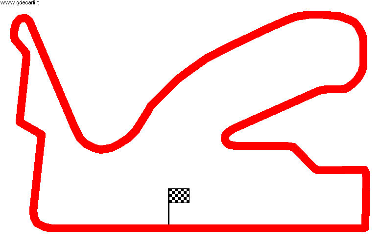
Seinäjoki 1973÷1983
Due to technical problems, temporarily it’s no longer possible to see the circuits on Google Maps embedded in the current page.
This feature will be restored as soon as I figure out how to do (any help would be appreciated!)
See this track layout with Google Earth
- milermeter.com
(milermeter.com can be used in your browser, without installing anything; Google Earth is a program that must be installed in your computer)
(Map shown here above can show at the same time all eventual layouts drawn. If you want to see only some of them, please go to Google Maps or Google Earth, by clicking on its own link)
| Updates | |||||||
| Date | Track layout | Years | Description by | Map by | Thanks to | Note | |
| September 23rd 2010 | Guido de Carli | Guido de Carli | David Griac (jpm) | Update | Description with map | ||
| February 14th 2007 | 1986÷1988 | Guido de Carli | New | Description without map | |||
| Not all eventual updates issued in last years are already visible in this list | |||||||


