| USA - UNITED STATES | |||||
| COURTLAND AIR BASE | |||||
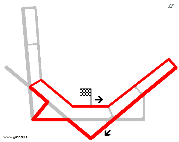
| Description | Abandoned circuit; today some parts of the airfield are residential areas and runways are ordinary streets | ||||
| Location | Courtland AL - Alabama - Southern States | ||||
| Location | |||||
| Latitude - Longitude | + 34°39'29" - 87°20'46" 34.658056 -87.346111 | ||||
| UTM Coordinates | X = 468285.906 - Y = 3835178.317 - Zone 16S | ||||
| Aerial photo / Map (*) |  OpenStreetMap - Google Maps - Bing Maps - Flash Earth - Wikimapia - Microsoft Research Maps - MapQuest OpenStreetMap - Google Maps - Bing Maps - Flash Earth - Wikimapia - Microsoft Research Maps - MapQuest | ||||
| Altitude AMSL | 173 m - 568 ft | ||||
| Inauguration | 1955 | ||||
| Closing | 1963 | ||||
| Designer | |||||
| Sources and links (Translation) (**) |
| ||||
| Courtland Air Base | |||||
| Description | |||||
| Years | |||||
| Direction |  Clockwise Clockwise | ||||
 Proposal Proposal |
NO | ||||
| No longer operational | YES | ||||
| Car Circuit | YES | ||||
| Motorbike circuit | |||||
| Type | Airfield course | ||||
| Inauguration | |||||
| Closing | |||||
| Last update of this page | February 12th 2007 | ||||
| Info last update | |||||
| Designer | |||||
| Distinctive points | |||||
| length | 5150 m | 16896 ft | 3.2 mi | (1) | |
Courtland Air Base
| Updates | |||||||
| Date | Track layout | Years | Description by | Map by | Thanks to | Note | |
| April 21st 2007 | Lorenzo Tommasi | Update | Map | ||||
| February 12th 2007 | Guido de Carli | ||||||
| Not all eventual updates issued in last years are already visible in this list | |||||||


