| RUS - RUSSIA | |||||||||
| TUSHINO / ТУШИНО | |||||||||
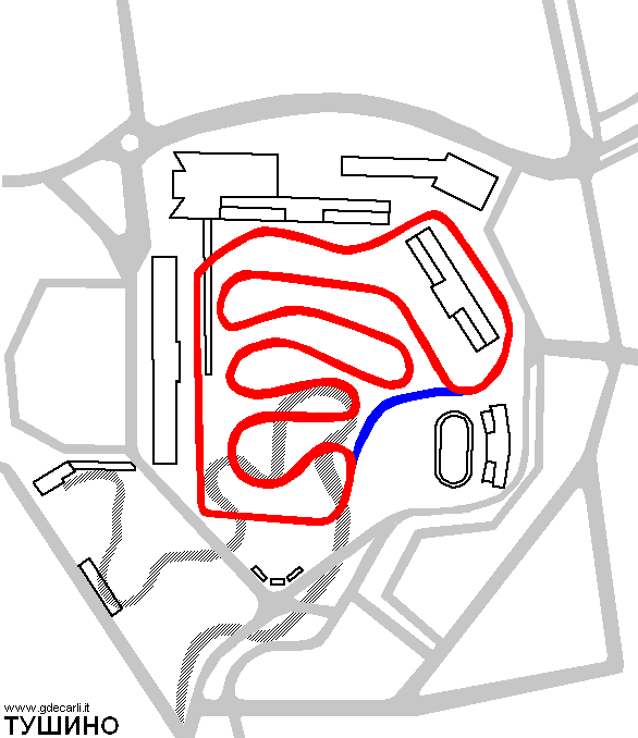
| Description | The first project of a Soviet F1 circuit appeared in 1964-65. It was researched in Moscow Auto and Road Institute (MADI). According to this project, the track should be built on the flood-lands of the Skhodnya river in Moscow. About 100 hectars of them were available to build a circuit, and high 35-metre slopes of the valley were very good as stands. There were more then twenty alternative designs of the circuit proposed, all with the track height from 16 to 20 metres, large boxes area, stands for 150000 spectators, the hotel for 5000 people, restaurants, and the Central Automotoclub building. Naturally, this project turned out to be too expensive, and nobody really wanted to build such a circuit. | ||||||||
| Location | Tushino, Moskva - Moskva - Tsentralny / Central | ||||||||
| Location | |||||||||
| Latitude - Longitude (approx) | + 55°49'00" + 37°25'40" (approx) 55.816667 37.427778 (approx) | ||||||||
| UTM Coordinates (approx) | X = 401484.825 - Y = 6186793.687 - Zone 37U (approx) | ||||||||
| Aerial photo / Map (*) |  OpenStreetMap - Google Maps - Bing Maps - Flash Earth - Wikimapia - New Kosmosnimki - Yandex OpenStreetMap - Google Maps - Bing Maps - Flash Earth - Wikimapia - New Kosmosnimki - Yandex | ||||||||
| Altitude AMSL (approx) | 125 m - 410 ft (approx) | ||||||||
| Inauguration | |||||||||
| Closing | |||||||||
| Designer | |||||||||
| Sources and links (Translation) (**) |
| ||||||||
| Tushino / Тушино | |||||
| Description | |||||
| Years | 1964÷1965 | ||||
| Direction | |||||
 Proposal Proposal |
YES
| ||||
| Proposal not developed | YES | ||||
| Car Circuit | YES | ||||
| Motorbike circuit | |||||
| Type | Permanent | ||||
| Inauguration | |||||
| Closing | |||||
| Last update of this page | November 7th 2003 | ||||
| Info last update | January 2000 | ||||
| Designer | |||||
| Distinctive points | |||||
| Min width | 16 m | 52 ft | |||
| Max width | 20 m | 66 ft | |||
Tushino
| Updates | |||||||
| Date | Track layout | Years | Description by | Map by | Thanks to | Note | |
| November 7th 2003 | Guido de Carli | Update | Description | ||||
| November 5th 2003 | Guido de Carli | Guido de Carli | New | Description with map | |||
| Not all eventual updates issued in last years are already visible in this list | |||||||


