| ESP - SPAIN | |||||||||||||||||||||
| SANTA CRUZ DE TENERIFE (CEPSA-OFRA) | |||||||||||||||||||||
| Not to be confused with | Puerto de la Cruz (Ciudad Turística) - Santa Cruz de Tenerife (1968) - Tenerife (1968) - Tenerife (2006) | ||||||||||||||||||||
| Description | Forum (no longer available) wher I found info about this circuit probably was quite confused. It reported that Circuito de Puerto la Cruz had been used from 1965 to probably 1972, but it shows track layout of CEPSA-Ofra located in Santa Cruz de Tenerife. Distance between two cities (Puerto de la Cruz and Santa Cruz de Tenerife) is approx 35 km - 22 mi and both hosted car races in that period. | ||||||||||||||||||||
| Location | Santa Cruz de Tenerife TF - Santa Cruz de Tenerife - Canarias | ||||||||||||||||||||
| Location | |||||||||||||||||||||
| Latitude - Longitude | + 28°27'26" - 16°17'04" 28.457222 -16.284444 | ||||||||||||||||||||
| UTM Coordinates | X = 374241.499 - Y = 3148524.641 - Zone 28R | ||||||||||||||||||||
| Aerial photo / Map (*) |  OpenStreetMap - Google Maps - Bing Maps - Flash Earth - Wikimapia - Visor SIGPAC OpenStreetMap - Google Maps - Bing Maps - Flash Earth - Wikimapia - Visor SIGPAC | ||||||||||||||||||||
| Altitude AMSL | 240 m - 787 ft | ||||||||||||||||||||
| Inauguration | 1965 | ||||||||||||||||||||
| Closing | |||||||||||||||||||||
| Designer | |||||||||||||||||||||
| Sources and links (Translation) (**) |
| ||||||||||||||||||||
| Circuito CEPSA-Ofra | |||||
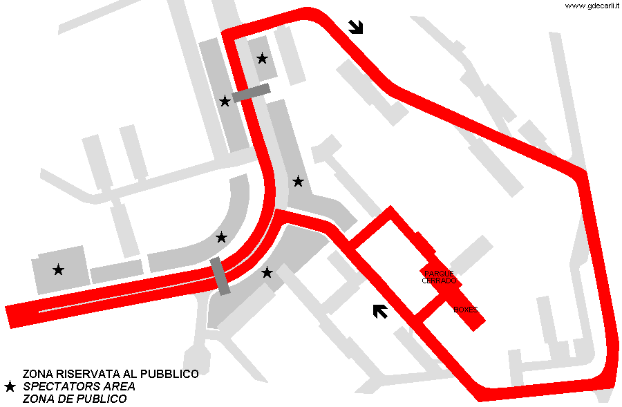
| Description | Street circuit used at least for 6th and 7th Premio de Tenerife on April 26th 1970 and May 2nd 1971. I don’t know if it had been used some more times, before and/or later. My unreliable sources reported it was used from 1965 to - probably - 1972, but I doubt it. | ||||
| Years | 1965?÷1970÷1971÷1972? | ||||
| Direction |  Clockwise Clockwise | ||||
 Proposal Proposal |
NO | ||||
| No longer operational | YES | ||||
| Car Circuit | YES | ||||
| Motorbike circuit | |||||
| Type | Street course | ||||
| Inauguration | |||||
| Closing | |||||
| Last update of this page | October 20th 2019 | ||||
| Info last update | |||||
| Designer | |||||
| Distinctive points | Calle Elisa Baccallado - Avenida Princesa de España - Calle Conde de Pallasar - Calle Santa Maria Soledad - Calle Nicolás Gonzáles Sopranis - Calle Elisa Baccallado | ||||
| length | 2500 m | 8202 ft | 1.553 mi | (3) | |
| length | 2500 m | 8202 ft | 1.553 mi | (2) | |
| length | 2850 m | 9350 ft | 1.771 mi | (1) | |
| length | 2506 m | 8222 ft | 1.557 mi | Calculated from aerial photo (*) | (4) |
| Difference in level | 66 m | 217 ft | Calculated from aerial photo (*) | (4) | |
| Circuito de las Avenidas | |||||
| Description | I don’t know if it is Circuit CEPSA-OFRA with a different name or if it is a different one | ||||
| Years | 1966 | ||||
| Direction | |||||
| Proposal |
NO | ||||
| No longer operational | YES | ||||
| Car Circuit | |||||
| Motorbike circuit | |||||
| Type | |||||
| Inauguration | 1966 | ||||
| Closing | 1966 | ||||
| Last update of this page | February 13th 2009 | ||||
| Info last update | |||||
| Designer | |||||
| Distinctive points | |||||
| length | 2500 m | 8202 ft | 1.553 mi | (1) | |
Santa Cruz de Tenerife (CEPSA-Ofra)
Due to technical problems, temporarily it’s no longer possible to see the circuits on Google Maps embedded in the current page.
This feature will be restored as soon as I figure out how to do (any help would be appreciated!)
See this track layout with Google Earth
- milermeter.com
(milermeter.com can be used in your browser, without installing anything; Google Earth is a program that must be installed in your computer)
(Map shown here above can show at the same time all eventual layouts drawn. If you want to see only some of them, please go to Google Maps or Google Earth, by clicking on its own link)
| Updates | |||||||
| Date | Track layout | Years | Description by | Map by | Thanks to | Note | |
| October 20th 2019 | Circuito CEPSA-Ofra | 1965?÷1970÷1971÷1972? | Guido de Carli | Update | Description | ||
| October 18th 2019 | Guido de Carli | Guido de Carli | Marco Cot | Update | Description with map | ||
| May 11th 2007 | Circuito CEPSA-Ofra | 1965?÷1970÷1971÷1972? | Guido de Carli | Update | Description | ||
| March 11th 2005 | Circuito CEPSA-Ofra | 1965?÷1970÷1971÷1972? | Guido de Carli | Guido de Carli | Update | Description with map | |
| November 11th 2004 | Circuito CEPSA-Ofra | 1965?÷1970÷1971÷1972? | Guido de Carli | New | Description | ||
| Not all eventual updates issued in last years are already visible in this list | |||||||


