| BOL - BOLIVIA | |||||||||
| PUCARANI | |||||||||
| Description | |||||||||
| Location | Pucarani - La Paz | ||||||||
| Location | Near La Paz, on the road to Titicaca Lake | ||||||||
| Latitude - Longitude | - 16°24'34" - 68°28'17" -16.409444 -68.471389 | ||||||||
| UTM Coordinates | X = 556440.988 - Y = 8185699.789 - Zone 19K | ||||||||
| Aerial photo / Map (*) |  OpenStreetMap - Google Maps - Bing Maps - Flash Earth - Wikimapia OpenStreetMap - Google Maps - Bing Maps - Flash Earth - Wikimapia | ||||||||
| Altitude AMSL | 3848 m - 12625 ft | ||||||||
| Inauguration | |||||||||
| Closing | |||||||||
| Designer | |||||||||
| Sources and links (Translation) (**) |
| ||||||||
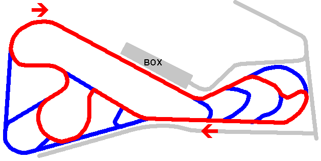
| Pucarani | |||||
| Description | |||||
| Years | |||||
| Direction |  Clockwise Clockwise | ||||
 Proposal Proposal |
NO | ||||
| No longer operational | |||||
| Car Circuit | YES | ||||
| Motorbike circuit | |||||
| Type | Permanent | ||||
| Inauguration | |||||
| Closing | |||||
| Last update of this page | August 12th 2005 | ||||
| Info last update | February 1995 | ||||
| Designer | |||||
| Distinctive points | |||||
| length (approx) | 3500 m | 11483 ft | 2.175 mi | (2) | |
Pucarani
| Updates | |||||||
| Date | Track layout | Years | Description by | Map by | Thanks to | Note | |
| August 12th 2005 | Guido de Carli | Update | Description | ||||
| Not all eventual updates issued in last years are already visible in this list | |||||||


