| USA - UNITED STATES | |||||||||||||||||||||||||||||||||||||||||||||||||||||||||
| MIAMI, BICENTENNIAL PARK MIAMI EPRIX MIAMI, BISCAYNE BAY | |||||||||||||||||||||||||||||||||||||||||||||||||||||||||
| SORRY, SOME DATA ARE NOT TRANSLATED YET | |||||||||||||||||||||||||||||||||||||||||||||||||||||||||
| Not to be confused with | Master Field - Miami (F.1 199x) - Miami (F.1 2019) - Miami, Bayfront Park - Miami, Hard Rock Stadium (F.1 2022) - Tamiami Park | ||||||||||||||||||||||||||||||||||||||||||||||||||||||||
| Description | |||||||||||||||||||||||||||||||||||||||||||||||||||||||||
| Location | Miami FL - Florida - Southern States | ||||||||||||||||||||||||||||||||||||||||||||||||||||||||
| Location | Bicentennial Park and Biscayne Boulevard; very close to Bayfront Park where there is another street circuit used from 2002. | ||||||||||||||||||||||||||||||||||||||||||||||||||||||||
| Latitude - Longitude | + 25°46'55" - 80°11'12" 25.781944 -80.186667 | ||||||||||||||||||||||||||||||||||||||||||||||||||||||||
| UTM Coordinates | X = 581547.866 - Y = 2851787.637 - Zone 17R | ||||||||||||||||||||||||||||||||||||||||||||||||||||||||
| Aerial photo / Map (*) |  OpenStreetMap - Google Maps - Bing Maps - Flash Earth - Wikimapia - Microsoft Research Maps - MapQuest OpenStreetMap - Google Maps - Bing Maps - Flash Earth - Wikimapia - Microsoft Research Maps - MapQuest | ||||||||||||||||||||||||||||||||||||||||||||||||||||||||
| Altitude AMSL | 1 m - 3 ft | ||||||||||||||||||||||||||||||||||||||||||||||||||||||||
| Inauguration | February 1983 | ||||||||||||||||||||||||||||||||||||||||||||||||||||||||
| Closing | 1995 | ||||||||||||||||||||||||||||||||||||||||||||||||||||||||
| Designer | |||||||||||||||||||||||||||||||||||||||||||||||||||||||||
| Sources and links (Translation) (**) |
| ||||||||||||||||||||||||||||||||||||||||||||||||||||||||
| Bicentennial Park | |||||
| Description | Street circuit, used by IMSA in 1983. In 1985 another street circuit was built on the same streets; on racingcircuits.net is possible to see both circuits on the same map. | ||||
| Years | 1983÷1985 | ||||
| Direction |  Clockwise Clockwise | ||||
 Proposal Proposal |
NO | ||||
| No longer operational | YES | ||||
| Car Circuit | YES | ||||
| Motorbike circuit | |||||
| Type | Street course | ||||
| Inauguration | February 1983 | ||||
| Closing | 1985 | ||||
| Last update of this page | June 29th 2006 | ||||
| Info last update | |||||
| Designer | |||||
| Distinctive points | |||||
| length | 2977 m | 9768 ft | 1.85 mi | (7) | |
| Bicentennial Park | |||||
| Description | Preliminary proposal for the new track layout | ||||
| Years | 1985 | ||||
| Direction |  Anticlockwise Anticlockwise | ||||
| Proposal |
YES
| ||||
| Proposal not developed | YES | ||||
| Car Circuit | YES | ||||
| Motorbike circuit | |||||
| Type | Street course | ||||
| Inauguration | |||||
| Closing | |||||
| Last update of this page | June 29th 2006 | ||||
| Info last update | |||||
| Designer | |||||
| Distinctive points | |||||
| Bicentennial Park | |||||
| Description | |||||
| Years | 1986÷1994 | ||||
| Direction | Anticlockwise | ||||
| Proposal |
NO | ||||
| No longer operational | YES | ||||
| Car Circuit | YES | ||||
| Motorbike circuit | |||||
| Type | Street course | ||||
| Inauguration | 1986 | ||||
| Closing | 1994 | ||||
| Last update of this page | September 25th 2021 | ||||
| Info last update | |||||
| Designer | |||||
| Distinctive points | |||||
| length | 3014 m | 9889 ft | 1.873 mi | (7) | |
| length | 2936 m | 9634 ft | 1.825 mi | Calculated from aerial photo (*) | (6) |
| Difference in level | 3 m | 10 ft | Calculated from aerial photo (*) | (6) | |
| Bicentennial Park | |||||
| Description | |||||
| Years | 1995 | ||||
| Direction | Clockwise | ||||
| Proposal |
NO | ||||
| No longer operational | YES | ||||
| Car Circuit | YES | ||||
| Motorbike circuit | |||||
| Type | Street course | ||||
| Inauguration | 1995 | ||||
| Closing | 1995 | ||||
| Last update of this page | September 25th 2021 | ||||
| Info last update | |||||
| Designer | |||||
| Distinctive points | |||||
| length | 3014 m | 9889 ft | 1.873 mi | (7) | |
| length | 2941 m | 9651 ft | 1.828 mi | Calculated from aerial photo (*) | (5) |
| Difference in level | 4 m | 13 ft | Calculated from aerial photo (*) | (5) | |
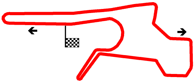
| Biscayne Bay Street Circuit | |||||
| Description | Circuit used for Miami ePrix, an event of the 2014/2015 Formula E championship. | ||||
| Years | 2015 | ||||
| Direction | Clockwise | ||||
| Proposal |
YES
| ||||
| Proposal not developed | |||||
| Car Circuit | YES | ||||
| Motorbike circuit | |||||
| Type | Street course | ||||
| Inauguration | March 14th 2015 | ||||
| Closing | March 14th 2015 | ||||
| Last update of this page | September 25th 2021 | ||||
| Info last update | |||||
| Designer | |||||
| Distinctive points | |||||
| length | 2170 m | 7119 ft | 1.348 mi | (3) | |
| length | 2170 m | 7119 ft | 1.348 mi | (8) | |
| length | 2187 m | 7176 ft | 1.359 mi | Calculated from aerial photo (*) | (4) |
Miami: all circuits
Due to technical problems, temporarily it’s no longer possible to see the circuits on Google Maps embedded in the current page.
This feature will be restored as soon as I figure out how to do (any help would be appreciated!)
See this track layout with Google Earth
Due to technical problems, temporarily it’s no longer possible to see the circuits on Google Maps embedded in the current page.
This feature will be restored as soon as I figure out how to do (any help would be appreciated!)
Google Earth
(milermeter.com can be used in your browser, without installing anything; Google Earth is a program that must be installed in your computer)
(Map shown here above can show at the same time all eventual layouts drawn. If you want to see only some of them, please go to Google Maps or Google Earth, by clicking on its own link)
Miami, Bicentennial Park 1983÷1985
Miami: Bayfront Park (yellow) and Bicentennial Park (red), photo taken on February 28th 1999
 Bayfront Park (yellow) and Bicentennial Park (red), photo taken on February 28th 1999" />
Miami: Bayfront Park (yellow) and Bicentennial Park (red), photo taken on February 28th 1999
Due to technical problems, temporarily it’s no longer possible to see the circuits on Google Maps embedded in the current page.
This feature will be restored as soon as I figure out how to do (any help would be appreciated!)
See this track layout with Google Earth
- milermeter.com
(milermeter.com can be used in your browser, without installing anything; Google Earth is a program that must be installed in your computer)
(Map shown here above can show at the same time all eventual layouts drawn. If you want to see only some of them, please go to Google Maps or Google Earth, by clicking on its own link)
Miami, Bicentennial Park 1995
Due to technical problems, temporarily it’s no longer possible to see the circuits on Google Maps embedded in the current page.
This feature will be restored as soon as I figure out how to do (any help would be appreciated!)
See this track layout with Google Earth
- milermeter.com
(milermeter.com can be used in your browser, without installing anything; Google Earth is a program that must be installed in your computer)
(Map shown here above can show at the same time all eventual layouts drawn. If you want to see only some of them, please go to Google Maps or Google Earth, by clicking on its own link)
Miami, Biscayne Bay Street Circuit (Formula E 2015)
Due to technical problems, temporarily it’s no longer possible to see the circuits on Google Maps embedded in the current page.
This feature will be restored as soon as I figure out how to do (any help would be appreciated!)
See this track layout with Google Earth
- milermeter.com
(milermeter.com can be used in your browser, without installing anything; Google Earth is a program that must be installed in your computer)
(Map shown here above can show at the same time all eventual layouts drawn. If you want to see only some of them, please go to Google Maps or Google Earth, by clicking on its own link)
| Updates | |||||||
| Date | Track layout | Years | Description by | Map by | Thanks to | Note | |
| September 25th 2021 | Guido de Carli | Update | Map | ||||
| October 30th 2014 | Guido de Carli | Mat_Bont 46 14 | Mat_Bont 46 14 | Update | Description with map | ||
| October 30th 2014 | Biscayne Bay Street Circuit | 2015 | Guido de Carli | Peer Risch | Peer Risch | Update | Description with map |
| November 29th 2007 | Guido de Carli | Update | Description | ||||
| September 10th 2003 | Bicentennial Park | 1983÷1985 | Guido de Carli | Update | Description | ||
| September 10th 2003 | Bicentennial Park | 1985 | Guido de Carli | Update | Description | ||
| May 4th 2003 | Bicentennial Park | 1983÷1985 | Guido de Carli | Guido de Carli | Update | Description with map | |
| October 31st 2002 | Guido de Carli | Update | Description with map | ||||
| October 29th 2002 | Guido de Carli | Guido de Carli | New | Description with map | |||
| Not all eventual updates issued in last years are already visible in this list | |||||||


