| USA - UNITED STATES | |||||
| COLORADO AMATEUR MOTORSPORTS PARK | |||||
| Description | Proposed circuit, it should replace the old Second Creek Raceway, closed in 2005. As a matter of fact, Colorado Amateur Motorsports Associates (CAMA) and five presidents of Second Creek Charter Clubs suddenly decided to search as soon as possible a location where to build a new track for minor races and private tests. In Januart 2005 they bought a ground 1.295 km² - 320 acres wide close to Front Range Airport (Denver), close to trade area af 25 minutes from "Mousetrap", the junction between Highway 24 and Highway 40. In 2005 they found an agreement with Sutton Motorsports Intl. The circuit should be 3927 m - 2.44 mi long and, according to early info, it should have been ready within the beginning of 2006. Unfortunately, economical problems of Sutton Motorsport and closing of two more circuits in Colorado (Pike’s Peak and Mountain View in Mead) make the beginning of the works stop. At first they thought to delay the end of the works up to mid 2007, but lately they are thinking to replace this proposal, with another one without Sutton Motorsport support. This proposal should be in the countryside at Agate 96 km - 60 mi from Mousetrap, in a new ground 3.238 km² - 800 acres wide uesd now by CORE (Colorado Off Road Extreme). They should pave this track; the cost should be approx. 2 million US Dollars. | ||||
| Location | Front Range Airport CO - Colorado - Western States | ||||
| Location | Nearby Watkins and Denver, close to Front Range Airport | ||||
| Latitude - Longitude | + 39°47'25" -104°30'36" 39.790278 -104.51 | ||||
| UTM Coordinates | X = 541954.023 - Y = 4404595.363 - Zone 13S | ||||
| Aerial photo / Map (*) |  OpenStreetMap - Google Maps - Bing Maps - Flash Earth - Wikimapia - Microsoft Research Maps - MapQuest OpenStreetMap - Google Maps - Bing Maps - Flash Earth - Wikimapia - Microsoft Research Maps - MapQuest | ||||
| Altitude AMSL | 1659 m - 5443 ft | ||||
| Inauguration | |||||
| Closing | |||||
| Designer | |||||
| Sources and links (Translation) (**) |
| ||||
| Colorado Amateur Motorsports Park | |||||
| Description | |||||
| Years | |||||
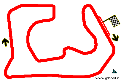
| Direction |  Clockwise Clockwise | ||||
 Proposal Proposal |
YES
| ||||
| Proposal not developed | |||||
| Car Circuit | YES | ||||
| Motorbike circuit | |||||
| Type | Permanent | ||||
| Inauguration | |||||
| Closing | |||||
| Last update of this page | May 9th 2006 | ||||
| Info last update | |||||
| Designer | |||||
| Distinctive points | |||||
| length | 3927 m | 12883 ft | 2.44 mi | (1) | |
| Total area | 130 hectares | 1295008 m² | 320 acres | (1) | |
Colorado Amateur Motorsports Park
| Updates | |||||||
| Date | Track layout | Years | Description by | Map by | Thanks to | Note | |
| May 29th 2007 | Lorenzo Tommasi | Lorenzo Tommasi | Update | Map | |||
| May 9th 2006 | Guido de Carli | Guido de Carli | Lorenzo Tommasi | New | Description with map | ||
| February 19th 2006 | Guido de Carli | Lorenzo Tommasi | New | Description | |||
| Not all eventual updates issued in last years are already visible in this list | |||||||


