| USA - UNITED STATES | |||||||||||||||||
| ST. PETERSBURG (TROPICANA FIELD) | |||||||||||||||||
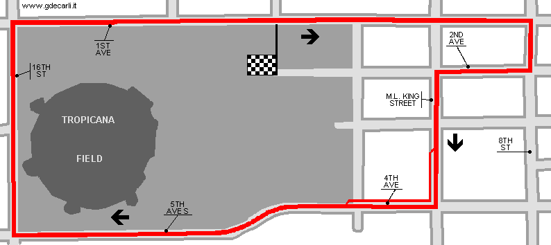
| Description | Circuit laid around Tropicana Field. This new location was necessary because of the evident dangerousness and obstruction of the old Bayfront circuit. It hosted Trans Am races from 1996 to 2000. The direction was clockwise and the start line was on the 1st Avenue. Then it went on 8th Avenue, on 2nd Avenue. Here it turned on Martin Luther King Street, where pits were. Then it went on 4th Avenue, 5th Avenue, 16th Street. After the latter, a 90° corner led towards finish line. In comparison to the previous circuit, this was more narrow and safer; drivers didn’t like it very much. In 2000 some works were made around Tropicana Field because of Final Four (I don’t know the sport): the area was changed and the circuit was abandoned. | ||||||||||||||||
| Location | St. Petersburg FL - Florida - Southern States | ||||||||||||||||
| Location | Along the streets outside Tropicana Field | ||||||||||||||||
| Latitude - Longitude | + 27°46'04" - 82°39'05" 27.767778 -82.651389 | ||||||||||||||||
| UTM Coordinates | X = 337271.676 - Y = 3072571.133 - Zone 17R | ||||||||||||||||
| Aerial photo / Map (*) |  OpenStreetMap - Google Maps - Bing Maps - Flash Earth - Wikimapia - Microsoft Research Maps - MapQuest OpenStreetMap - Google Maps - Bing Maps - Flash Earth - Wikimapia - Microsoft Research Maps - MapQuest | ||||||||||||||||
| Altitude AMSL | 6 m - 20 ft | ||||||||||||||||
| Inauguration | 1996 | ||||||||||||||||
| Closing | 2000 | ||||||||||||||||
| Designer | |||||||||||||||||
| Sources and links (Translation) (**) |
| ||||||||||||||||
| St. Petersburg (Tropicana Field) | |||||
| Description | |||||
| Years | 1996÷2000 | ||||
| Direction |  Clockwise Clockwise | ||||
 Proposal Proposal |
NO | ||||
| No longer operational | YES | ||||
| Car Circuit | YES | ||||
| Motorbike circuit | |||||
| Type | Street course | ||||
| Inauguration | 1996 | ||||
| Closing | 2000 | ||||
| Last update of this page | October 25th 2007 | ||||
| Info last update | |||||
| Designer | |||||
| Distinctive points | 1st Avenue - 8th Avenue - 2nd Avenue - Martin Luther King Street - 4th Avenue - 5th Avenue - 16th Street - 1st Avenue | ||||
| length | 2575 m | 8448 ft | 1.6 mi | (2) | |
St. Petersburg (Tropicana Field)
| Updates | |||||||
| Date | Track layout | Years | Description by | Map by | Thanks to | Note | |
| February 4th 2006 | Lorenzo Tommasi | Lorenzo Tommasi | Update | Description with map | |||
| May 4th 2003 | Guido de Carli | New | Description | ||||
| Not all eventual updates issued in last years are already visible in this list | |||||||


