| CAN - CANADA | |||||||||||||||||||||||||||||||||||||||||||||||||||||||||||||||||||||||||||||
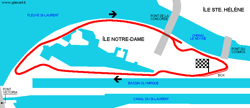
| MONTRÉAL, ÎLE NOTRE-DAME (GILLES VILLENEUVE) | |||||||||||||||||||||||||||||||||||||||||||||||||||||||||||||||||||||||||||||
| Not to be confused with | Montréal, Île Ste-Hélène - Montréal, Parc Olympique | ||||||||||||||||||||||||||||||||||||||||||||||||||||||||||||||||||||||||||||
| Description | |||||||||||||||||||||||||||||||||||||||||||||||||||||||||||||||||||||||||||||
| Location | Île Notre-Dame, Montréal QC - Québec - Eastern Canada | ||||||||||||||||||||||||||||||||||||||||||||||||||||||||||||||||||||||||||||
| Location | |||||||||||||||||||||||||||||||||||||||||||||||||||||||||||||||||||||||||||||
| Latitude - Longitude | + 45°30'05" - 73°31'22" 45.501389 -73.522778 | ||||||||||||||||||||||||||||||||||||||||||||||||||||||||||||||||||||||||||||
| UTM Coordinates | X = 615407.586 - Y = 5039712.093 - Zone 18T | ||||||||||||||||||||||||||||||||||||||||||||||||||||||||||||||||||||||||||||
| Aerial photo / Map (*) |  OpenStreetMap - Google Maps - Bing Maps - Flash Earth - Wikimapia - MapQuest OpenStreetMap - Google Maps - Bing Maps - Flash Earth - Wikimapia - MapQuest | ||||||||||||||||||||||||||||||||||||||||||||||||||||||||||||||||||||||||||||
| Altitude AMSL | 7 m - 23 ft | ||||||||||||||||||||||||||||||||||||||||||||||||||||||||||||||||||||||||||||
| Inauguration | September 24th 1978 | ||||||||||||||||||||||||||||||||||||||||||||||||||||||||||||||||||||||||||||
| Closing | |||||||||||||||||||||||||||||||||||||||||||||||||||||||||||||||||||||||||||||
| Designer | |||||||||||||||||||||||||||||||||||||||||||||||||||||||||||||||||||||||||||||
| Sources and links (Translation) (**) |
| ||||||||||||||||||||||||||||||||||||||||||||||||||||||||||||||||||||||||||||
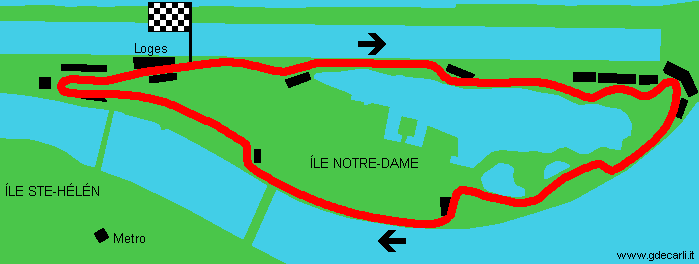
| Circuit Île Notre-Dame | |||||
| Description | Already in 1976 there were rumors for moving F.1 GP to Montréal. This is first proposal dated summer 1978 for Île Notre Dame street circuit, inaugurated (with a slightly different layout) by F.1 on October 7th 1978. | ||||
| Years | 1978 | ||||
| Direction |  Clockwise Clockwise | ||||
 Proposal Proposal |
YES
| ||||
| Proposal not developed | YES | ||||
| Car Circuit | YES | ||||
| Motorbike circuit | |||||
| Type | Street course | ||||
| Inauguration | |||||
| Closing | |||||
| Last update of this page | July 17th 2011 | ||||
| Info last update | July 1978 | ||||
| Designer | |||||
| Distinctive points | |||||
| length | 4587 m | 15048 ft | 2.85 mi | (8) | |
| length (approx) | 4600 m | 15092 ft | 2.858 mi | Approximated length | (10) |
| length | 4224 m | 13858 ft | 2.625 mi | Calculated from aerial photo (*) | (2) |
| Circuit Île Notre-Dame | |||||
| Description | Street circuit inaugurated on September 24th and used for Canadian F.1 GP on October 7th 1978. Following years it has been slightly modified. | ||||
| Years | 1978 | ||||
| Direction | Clockwise | ||||
| Proposal |
NO | ||||
| No longer operational | YES | ||||
| Car Circuit | YES | ||||
| Motorbike circuit | |||||
| Type | Street course | ||||
| Inauguration | September 24th 1978 | ||||
| Closing | October 7th 1978 | ||||
| Last update of this page | July 17th 2011 | ||||
| Info last update | |||||
| Designer | |||||
| Distinctive points | |||||
| length | 4500 m | 14764 ft | 2.796 mi | (11) | |
| length | 4457 m | 14623 ft | 2.77 mi | Calculated from aerial photo (*) | (2) |
| Circuit Île Notre-Dame (Gilles Villeneuve) | |||||
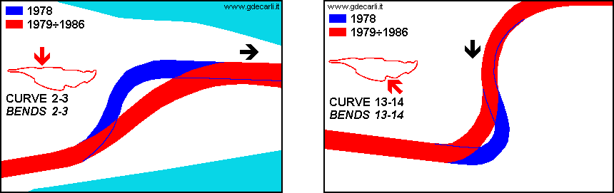
| Description | Bends 2-3 and 13-14 have been changed (see details). This circuits was named after Gilles Villeneuve few days after his death (occurred on May 8th 1982), before 1982 GP (held on June 13th 1982). | ||||
| Years | 1979÷1986 | ||||
| Direction | Clockwise | ||||
| Proposal |
NO | ||||
| No longer operational | YES | ||||
| Car Circuit | YES | ||||
| Motorbike circuit | |||||
| Type | Street course | ||||
| Inauguration | 1979 | ||||
| Closing | 1986 | ||||
| Last update of this page | July 17th 2011 | ||||
| Info last update | |||||
| Designer | |||||
| Distinctive points | |||||
| length | 4410 m | 14469 ft | 2.74 mi | (12) | |
| length | 4439 m | 14564 ft | 2.758 mi | Calculated from aerial photo (*) | (2) |
| Circuit Gilles Villeneuve | |||||
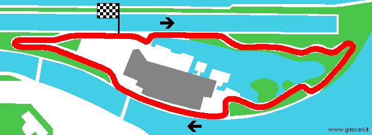
| Description | Compared to the previous layout, pits and start/finish line have been moved and a new starting straight was created by removing a kink | ||||
| Years | 1988÷1990 | ||||
| Direction | Clockwise | ||||
| Proposal |
NO | ||||
| No longer operational | YES | ||||
| Car Circuit | YES | ||||
| Motorbike circuit | |||||
| Type | Street course | ||||
| Inauguration | 1988 | ||||
| Closing | 1990 | ||||
| Last update of this page | July 17th 2011 | ||||
| Info last update | |||||
| Designer | |||||
| Distinctive points | |||||
| length | 4390 m | 14403 ft | 2.728 mi | (6) | |
| length | 4436 m | 14554 ft | 2.756 mi | Calculated from aerial photo (*) | (2) |
| Circuit Gilles Villeneuve | |||||
| Description | Compared to the previous layout, surely last chicane is changed (the one that since 1999 is famous because at its exit there is the Champions Wall). Moreover, the circuit has been extended of 40 m - 131 ft, but I have no more details. I can suppose that no more changes have been made, but tha track has been remeasured usinga new criterion, or that the track was changed somewhere else (maybe as usual at the hairpin, the last before pits used up to 1986), even if no sources report anything about. | ||||
| Years | 1991÷1993, 1995 | ||||
| Direction | Clockwise | ||||
| Proposal |
NO | ||||
| No longer operational | YES | ||||
| Car Circuit | YES | ||||
| Motorbike circuit | |||||
| Type | Street course | ||||
| Inauguration | 1991 | ||||
| Closing | 1995 | ||||
| Last update of this page | July 17th 2011 | ||||
| Info last update | |||||
| Designer | |||||
| Distinctive points | |||||
| length | 4430 m | 14534 ft | 2.753 mi | (8) | |
| length | 4430 m | 14534 ft | 2.753 mi | (6) | |
| length | 4439 m | 14564 ft | 2.758 mi | Calculated from aerial photo (*) | (2) |
| Circuit Gilles Villeneuve | |||||
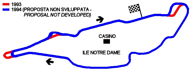
| Description | Proposal for slowing down the track proposed after Senna’s death (May 1st 1994) and before F.1 Canada GP, held on June 12nd 1994. The chicane should have to use the pit lane used until 1986. The circuit has really been modified, but not in such a way | ||||
| Years | 1994 | ||||
| Direction | Clockwise | ||||
| Proposal |
YES
| ||||
| Proposal not developed | YES | ||||
| Car Circuit | YES | ||||
| Motorbike circuit | |||||
| Type | Street course | ||||
| Inauguration | |||||
| Closing | |||||
| Last update of this page | July 17th 2011 | ||||
| Info last update | May 1994 | ||||
| Designer | |||||
| Distinctive points | |||||
| length | 4384 m | 14383 ft | 2.724 mi | Calculated from aerial photo (*) | (2) |
| Circuit Gilles Villeneuve | |||||
| Description | After arguments about Senna’s death, a tyre chicane was added using the place where up to 1986 there was the exit of pit lane | ||||
| Years | 1994 | ||||
| Direction | Clockwise | ||||
| Proposal |
NO | ||||
| No longer operational | YES | ||||
| Car Circuit | YES | ||||
| Motorbike circuit | |||||
| Type | Street course | ||||
| Inauguration | June 10th 1994 | ||||
| Closing | June 12th 1994 | ||||
| Last update of this page | July 17th 2011 | ||||
| Info last update | |||||
| Designer | |||||
| Distinctive points | |||||
| length | 4450 m | 14600 ft | 2.765 mi | (8) | |
| length | 4449 m | 14596 ft | 2.765 mi | Calculated from aerial photo (*) | (2) |
| Circuit Gilles Villeneuve | |||||
| Description | The kink after the old pit exit was replaced by a new long straight. The wall at the exit of thelast chicane after 1999 F.1 Canadian GP was nicknamed "Wall of Champions", because in that race three F.1 world championship (Damon Hill, Michael Schumacher and Jacques Villeneuve) and Ricardo Zonta (1998 FIA GT Champion) hit it and they had to retired. Funny that the wall has on it the slogan Bienvenue au Québec ("Welcome to Quebec") | ||||
| Years | 1996÷2001 | ||||
| Direction | Clockwise | ||||
| Proposal |
NO | ||||
| No longer operational | YES | ||||
| Car Circuit | YES | ||||
| Motorbike circuit | |||||
| Type | Street course | ||||
| Inauguration | 1996 | ||||
| Closing | 2001 | ||||
| Last update of this page | July 17th 2011 | ||||
| Info last update | |||||
| Designer | |||||
| Distinctive points | |||||
| length | 4421 m | 14505 ft | 2.747 mi | Official track length until 1999 (in 2000 FIA changed measuring system) | (17) |
| length | 4421 m | 14505 ft | 2.747 mi | Official track length from 2000, when FIA changed measuring system (track unchanged) | (18) |
| length | 4427 m | 14524 ft | 2.751 mi | Temporary track length (beginning of 2000), when FIA was changing measuring system (track unchanged) | (18) |
| length | 4434 m | 14547 ft | 2.755 mi | Calculated from aerial photo (*) | (2) |
| Circuit Gilles Villeneuve | |||||
| Description | New pit exit, the hairpin was shortened and the Champions Wall "Welcome to Québec" (at the last chicane, just before finish line) was moved. In 2005 the circuit was repaved and at last chicanes curbs and run-off aread were modified | ||||
| Years | 2002÷... | ||||
| Direction | Clockwise | ||||
| Proposal |
NO | ||||
| No longer operational | |||||
| Car Circuit | YES | ||||
| Motorbike circuit | |||||
| Type | Street course | ||||
| Inauguration | 2002 | ||||
| Closing | |||||
| Last update of this page | July 17th 2011 | ||||
| Info last update | |||||
| Designer | |||||
| Distinctive points | |||||
| length | 4361 m | 14308 ft | 2.71 mi | (8) | |
| length | 4370 m | 14337 ft | 2.715 mi | Calculated from aerial photo (*) | (2) |
Montréal: comparison between different circuits and layouts
Due to technical problems, temporarily it’s no longer possible to see the circuits on Google Maps embedded in the current page.
This feature will be restored as soon as I figure out how to do (any help would be appreciated!)
See this track layout with Google Earth
Due to technical problems, temporarily it’s no longer possible to see the circuits on Google Maps embedded in the current page.
This feature will be restored as soon as I figure out how to do (any help would be appreciated!)
Google Earth
(milermeter.com can be used in your browser, without installing anything; Google Earth is a program that must be installed in your computer)
(Map shown here above can show at the same time all eventual layouts drawn. If you want to see only some of them, please go to Google Maps or Google Earth, by clicking on its own link)
Montréal, Circuit Île Notre-Dame: summer 1978 proposal
Due to technical problems, temporarily it’s no longer possible to see the circuits on Google Maps embedded in the current page.
This feature will be restored as soon as I figure out how to do (any help would be appreciated!)
See this track layout with Google Earth
(milermeter.com can be used in your browser, without installing anything; Google Earth is a program that must be installed in your computer)
(Map shown here above can show at the same time all eventual layouts drawn. If you want to see only some of them, please go to Google Maps or Google Earth, by clicking on its own link)
Montréal, Circuit Île Notre-Dame: 1978 layout
Due to technical problems, temporarily it’s no longer possible to see the circuits on Google Maps embedded in the current page.
This feature will be restored as soon as I figure out how to do (any help would be appreciated!)
See this track layout with Google Earth
(milermeter.com can be used in your browser, without installing anything; Google Earth is a program that must be installed in your computer)
(Map shown here above can show at the same time all eventual layouts drawn. If you want to see only some of them, please go to Google Maps or Google Earth, by clicking on its own link)
Montréal, Circuit Île Notre-Dame (Gilles Villeneuve): 1979÷1986 layout
Due to technical problems, temporarily it’s no longer possible to see the circuits on Google Maps embedded in the current page.
This feature will be restored as soon as I figure out how to do (any help would be appreciated!)
See this track layout with Google Earth
(milermeter.com can be used in your browser, without installing anything; Google Earth is a program that must be installed in your computer)
(Map shown here above can show at the same time all eventual layouts drawn. If you want to see only some of them, please go to Google Maps or Google Earth, by clicking on its own link)
Montréal, Circuit Gilles Villeneuve: 1988÷1990 layout
Due to technical problems, temporarily it’s no longer possible to see the circuits on Google Maps embedded in the current page.
This feature will be restored as soon as I figure out how to do (any help would be appreciated!)
See this track layout with Google Earth
(milermeter.com can be used in your browser, without installing anything; Google Earth is a program that must be installed in your computer)
(Map shown here above can show at the same time all eventual layouts drawn. If you want to see only some of them, please go to Google Maps or Google Earth, by clicking on its own link)
Montréal, Circuit Gilles Villeneuve: 1991÷1993 and 1995 layout
Due to technical problems, temporarily it’s no longer possible to see the circuits on Google Maps embedded in the current page.
This feature will be restored as soon as I figure out how to do (any help would be appreciated!)
See this track layout with Google Earth
(milermeter.com can be used in your browser, without installing anything; Google Earth is a program that must be installed in your computer)
(Map shown here above can show at the same time all eventual layouts drawn. If you want to see only some of them, please go to Google Maps or Google Earth, by clicking on its own link)
Montréal, Circuit Gilles Villeneuve: May 1994 proposal (not developed)
Due to technical problems, temporarily it’s no longer possible to see the circuits on Google Maps embedded in the current page.
This feature will be restored as soon as I figure out how to do (any help would be appreciated!)
See this track layout with Google Earth
(milermeter.com can be used in your browser, without installing anything; Google Earth is a program that must be installed in your computer)
(Map shown here above can show at the same time all eventual layouts drawn. If you want to see only some of them, please go to Google Maps or Google Earth, by clicking on its own link)
Montréal, Circuit Gilles Villeneuve: 1994 layout
Due to technical problems, temporarily it’s no longer possible to see the circuits on Google Maps embedded in the current page.
This feature will be restored as soon as I figure out how to do (any help would be appreciated!)
See this track layout with Google Earth
(milermeter.com can be used in your browser, without installing anything; Google Earth is a program that must be installed in your computer)
(Map shown here above can show at the same time all eventual layouts drawn. If you want to see only some of them, please go to Google Maps or Google Earth, by clicking on its own link)
Montréal, Circuit Gilles Villeneuve: 1996÷2001 layout
Due to technical problems, temporarily it’s no longer possible to see the circuits on Google Maps embedded in the current page.
This feature will be restored as soon as I figure out how to do (any help would be appreciated!)
See this track layout with Google Earth
(milermeter.com can be used in your browser, without installing anything; Google Earth is a program that must be installed in your computer)
(Map shown here above can show at the same time all eventual layouts drawn. If you want to see only some of them, please go to Google Maps or Google Earth, by clicking on its own link)
Montréal, Circuit Gilles Villeneuve: 2002÷... layout
Due to technical problems, temporarily it’s no longer possible to see the circuits on Google Maps embedded in the current page.
This feature will be restored as soon as I figure out how to do (any help would be appreciated!)
See this track layout with Google Earth
(milermeter.com can be used in your browser, without installing anything; Google Earth is a program that must be installed in your computer)
(Map shown here above can show at the same time all eventual layouts drawn. If you want to see only some of them, please go to Google Maps or Google Earth, by clicking on its own link)
| Updates | |||||||
| Date | Track layout | Years | Description by | Map by | Thanks to | Note | |
| July 17th 2011 | Guido de Carli | Roelard Smit | Roelard Smit | Update | Description with map | ||
| July 16th 2011 | Guido de Carli | Roelard Smit | Roelard Smit | Update | Description with map | ||
| June 13th 2011 | Circuit Île Notre-Dame | 1978 | Guido de Carli | Cri | Update | Description | |
| December 13th 2007 | Circuit Gilles Villeneuve | 2002÷... | Guido de Carli | Update | Description | ||
| August 12th 2005 | Guido de Carli | Update | Description | ||||
| December 20th 2004 | Circuit Île Notre-Dame | 1978 | Guido de Carli | Guido de Carli | Update | Map | |
| December 27th 2003 | Circuit Île Notre-Dame (Gilles Villeneuve) | 1979÷1986 | Guido de Carli | Update | Description | ||
| September 27th 2003 | Circuit Île Notre-Dame | 1978 | Guido de Carli | Guido de Carli | Update | Description with map | |
| August 7th 2002 | Guido de Carli | New | Description without map | ||||
| Not all eventual updates issued in last years are already visible in this list | |||||||


