| BRA - BRAZIL | |||||||||||||||||||||||||||||||||||||||||||||
| TARUMÃ | |||||||||||||||||||||||||||||||||||||||||||||
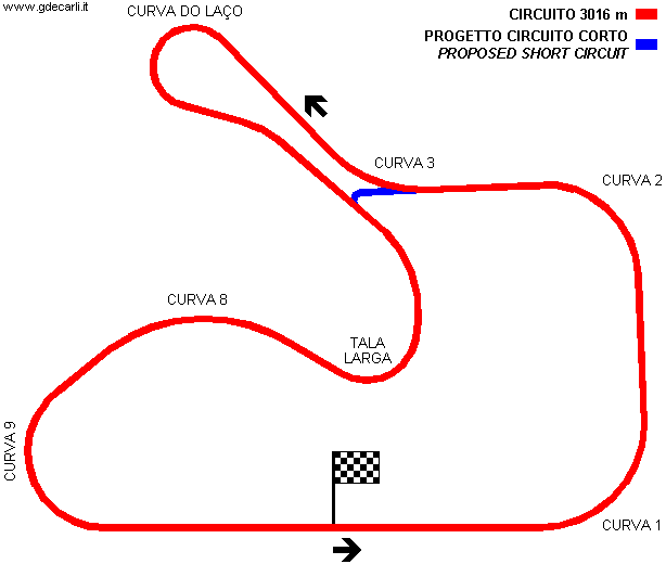
| Description | Road circuit first used on November 8th 1970; it’s 12 m wide (15 m on main straight). First proposal had also a short circuit, as you can see on map sent me by Leomar Nestor Teichmann, but it was never built | ||||||||||||||||||||||||||||||||||||||||||||
| Location | Viamão RS - Rio Grande do Sul - Região Sul | ||||||||||||||||||||||||||||||||||||||||||||
| Location | Viamão, 30 km - 18 mi from Porto Alegre, in Rio Grande do Sul | ||||||||||||||||||||||||||||||||||||||||||||
| Latitude - Longitude | - 30°02'54" - 51°01'04" -30.048333 -51.017778 | ||||||||||||||||||||||||||||||||||||||||||||
| UTM Coordinates | X = 498286.185 - Y = 6675858.807 - Zone 22J | ||||||||||||||||||||||||||||||||||||||||||||
| Aerial photo / Map (*) |  OpenStreetMap - Google Maps - Bing Maps - Flash Earth - Wikimapia OpenStreetMap - Google Maps - Bing Maps - Flash Earth - Wikimapia | ||||||||||||||||||||||||||||||||||||||||||||
| Altitude AMSL | 66 m - 217 ft | ||||||||||||||||||||||||||||||||||||||||||||
| Inauguration | November 8th 1970 | ||||||||||||||||||||||||||||||||||||||||||||
| Closing | |||||||||||||||||||||||||||||||||||||||||||||
| Designer | |||||||||||||||||||||||||||||||||||||||||||||
| Sources and links (Translation) (**) |
| ||||||||||||||||||||||||||||||||||||||||||||
| Autódromo Internacional de Tarumã | |||||
Long circuit | |||||
| Description | |||||
| Years | |||||
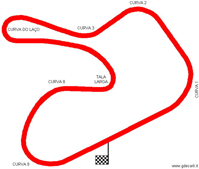
| Direction |  Anticlockwise Anticlockwise | ||||
 Proposal Proposal |
NO | ||||
| No longer operational | |||||
| Car Circuit | YES | ||||
| Motorbike circuit | |||||
| Type | Permanent | ||||
| Inauguration | November 8th 1970 | ||||
| Closing | |||||
| Last update of this page | May 20th 2004 | ||||
| Info last update | |||||
| Designer | |||||
| Distinctive points | Curva 1 - Curva 2 - Curva 3 - Curva Do Laço - Tala Larga - Curva 8 - Curva 9 | ||||
| length | 3015 m | 9892 ft | 1.873 mi | Long circuit | (5) |
| length | 3016 m | 9895 ft | 1.874 mi | Long circuit | (8) |
| Min width | 12 m | 39 ft | (1) | ||
| Max width | 15 m | 49 ft | (1) | ||
| Autódromo Internacional de Tarumã | |||||
Short circuit | |||||
| Description | |||||
| Years | |||||
| Direction | Anticlockwise | ||||
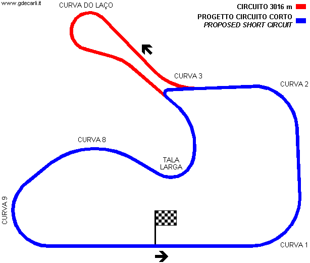
| Proposal |
YES
| ||||
| Proposal not developed | YES | ||||
| Car Circuit | YES | ||||
| Motorbike circuit | |||||
| Type | Permanent | ||||
| Inauguration | |||||
| Closing | |||||
| Last update of this page | May 20th 2004 | ||||
| Info last update | |||||
| Designer | |||||
| Distinctive points | Curva 1 - Curva 2 - Tala Larga - Curva 8 - Curva 9 | ||||
| length | 2369 m | 7772 ft | 1.472 mi | Short circuit | |
| Kartódromo Internacional De Tarumã | |||||
| Description | Original kart track layout, in use until the circuit was extended in 1998 | ||||
| Years | |||||
| Direction | |||||
| Proposal |
NO | ||||
| No longer operational | YES | ||||
| Car Circuit | |||||
| Motorbike circuit | |||||
| Type | Kart track | ||||
| Inauguration | 1968 | ||||
| Closing | 1997 | ||||
| Last update of this page | December 8th 2007 | ||||
| Info last update | |||||
| Designer | |||||
| Distinctive points | |||||
| length (approx) | 830 m | 2723 ft | 0.516 mi | (4) | |
| Kartódromo Internacional De Tarumã | |||||
| Description | |||||
| Years | |||||
| Direction | |||||
| Proposal |
NO | ||||
| No longer operational | |||||
| Car Circuit | |||||
| Motorbike circuit | |||||
| Type | Kart track | ||||
| Inauguration | 1998 | ||||
| Closing | |||||
| Last update of this page | December 8th 2007 | ||||
| Info last update | |||||
| Designer | |||||
| Distinctive points | |||||
| length | 1000 m | 3281 ft | 0.621 mi | (6) | |
| length | 1000 m | 3281 ft | 0.621 mi | (10) | |
| length | 1030 m | 3379 ft | 0.64 mi | (4) | |
| Width | 8 m | 26 ft | (10) | ||
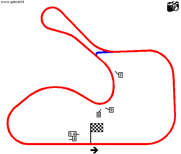
Leomar Nestor Teichmann’s map (slighly modified)
| PHOTOS |
| All photos were taken by Leomar Nestor Teichmann (but # 1, sent by him), reproduced here with kind permission. |
| Photos by Leomar Nestor Teichmann - |
| Click on thumbnail to open original large photo |
| 1 | 2 | 3 | 4 |
 |  |  |  |
| Aerial photo (taken in 1974) | Aerial photo | Aerial photo | Bend 9 exit, main straight and pit entry |
| 5 | 6 | 7 | 8 |
 |  |  |  |
| Main straight | Pit lane | Tala Larga; in background: Curva do Laço | Tala Larga |
| 9 | |||
 | |||
| Exit from Tala Larga and Bend 8 |
| Updates | |||||||
| Date | Track layout | Years | Description by | Map by | Thanks to | Note | |
| December 13th 2007 | Guido de Carli | Update | Description | ||||
| December 8th 2007 | Kartódromo Internacional De Tarumã | Guido de Carli | New | Description without map | |||
| May 27th 2004 | Guido de Carli | Update | Photos (on this site) | ||||
| May 22nd 2004 | Guido de Carli | Update | Description | ||||
| May 22nd 2004 | Guido de Carli | New | Photos (on this site) | ||||
| May 20th 2004 | Guido de Carli | Guido de Carli | Update | Description with map | |||
| May 14th 2004 | Guido de Carli | Guido de Carli | New | Description with map | |||
| August 23rd 2002 | Guido de Carli | New | Description | ||||
| Not all eventual updates issued in last years are already visible in this list | |||||||


