 Visualizza questa pagina in Italiano
 HOME PAGE
|
Visualizza questa pagina in Italiano
|
HOME PAGE
|
Legend and translations |
| VEN - VENEZUELA | |||||||||||||||||||||
| SAN CARLOS | |||||||||||||||||||||
| SORRY, SOME DATA ARE NOT TRANSLATED YET | |||||||||||||||||||||
| Description | |||||||||||||||||||||
| Location | San Carlos - Cojedes | ||||||||||||||||||||
| Location | |||||||||||||||||||||
| Latitude - Longitude | + 9°39'49" - 68°33'15" 9.663611 -68.554167 | ||||||||||||||||||||
| UTM Coordinates | X = 548911.18 - Y = 1068252.454 - Zone 19P | ||||||||||||||||||||
| Aerial photo / Map (*) |  Google Maps - Bing Maps - Flash Earth Google Maps - Bing Maps - Flash Earth | ||||||||||||||||||||
| Altitude AMSL | 154 m - 505 ft | ||||||||||||||||||||
| Inauguration | 1972 | ||||||||||||||||||||
| Closing | |||||||||||||||||||||
| Designer | |||||||||||||||||||||
| Sources and links (Translation) (**) |
| ||||||||||||||||||||
| San Carlos | |||||
| Description | Initial track layout. First international race should have been a non championship F.2 event scheduled on November 1972 and there were rumors for a non championship F.1 race to be scheduled on June 1972. Within 1973 the track should have been doubled. But I don’t know when it was really extended | ||||
| Years | 1972 | ||||
| Direction | |||||
 Proposal Proposal |
NO | ||||
| No longer operational | YES | ||||
| Car Circuit | YES | ||||
| Motorbike circuit | |||||
| Type | Permanent | ||||
| Inauguration | |||||
| Closing | |||||
| Last update of this page | March 28th 2007 | ||||
| Info last update | February 1972 | ||||
| Designer | |||||
| Distinctive points | |||||
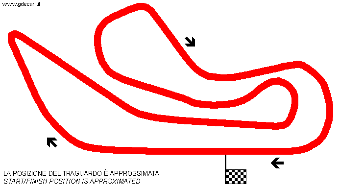
| length | 2700 m | 8858 ft | 1.678 mi | (4) | |
| Straight length | 800 m | 2625 ft | 0.497 mi | Opposite straight | (4) |
| San Carlos | |||||
| Description | |||||
| Years | |||||
| Direction |  Clockwise Clockwise | ||||
| Proposal |
NO | ||||
| No longer operational | |||||
| Car Circuit | YES | ||||
| Motorbike circuit | |||||
| Type | Permanent | ||||
| Inauguration | |||||
| Closing | |||||
| Last update of this page | May 6th 2009 | ||||
| Info last update | March 1979 | ||||
| Designer | |||||
| Distinctive points | |||||
| length | 4100 m | 13451 ft | 2.548 mi | (2) | |
| length | 4135 m | 13566 ft | 2.569 mi | (5) | |
| length | 4000 m | 13123 ft | 2.486 mi | Long circuit | (3) |
| length | 3000 m | 9843 ft | 1.864 mi | Short circuit | (3) |
| Width | 14 m | 46 ft | (2) | ||
| Width | 14.5 m | 48 ft | (3) | ||
| Straight length | 710 m | 2329 ft | 0.441 mi | Start finish straight | (3) |
| Straight length | 800 m | 2625 ft | 0.497 mi | Opposite straight | (3) |
Long course
| Updates | |||||||
| Date | Track layout | Years | Description by | Map by | Thanks to | Note | |
| March 28th 2007 | 1972 | Guido de Carli | |||||
| November 13th 2003 | Guido de Carli | Update | Description | ||||
| Not all eventual updates issued in last years are already visible in this list | |||||||
Webmaster:
Guido de Carli

(Italiano - English - Español)
HOME PAGE