 Visualizza questa pagina in Italiano
 HOME PAGE
|
Visualizza questa pagina in Italiano
|
HOME PAGE
|
Legend and translations |
| AUS - AUSTRALIA | |||||||||||||||||||||||||||||||||||||||||||||||||||||
| MELBOURNE, ALBERT PARK | |||||||||||||||||||||||||||||||||||||||||||||||||||||
| Description | |||||||||||||||||||||||||||||||||||||||||||||||||||||
| Location | Melbourne VIC - Victoria | ||||||||||||||||||||||||||||||||||||||||||||||||||||
| Location | |||||||||||||||||||||||||||||||||||||||||||||||||||||
| Latitude - Longitude | - 37°50'52" +144°58'14" -37.847778 144.970556 | ||||||||||||||||||||||||||||||||||||||||||||||||||||
| UTM Coordinates | X = 321443.247 - Y = 5809133.38 - Zone 55H | ||||||||||||||||||||||||||||||||||||||||||||||||||||
| Aerial photo / Map (*) |  Google Maps - Bing Maps - Flash Earth - NearMap Google Maps - Bing Maps - Flash Earth - NearMap | ||||||||||||||||||||||||||||||||||||||||||||||||||||
| Altitude AMSL | 9 m - 30 ft | ||||||||||||||||||||||||||||||||||||||||||||||||||||
| Inauguration | November 21st 1953 | ||||||||||||||||||||||||||||||||||||||||||||||||||||
| Closing | |||||||||||||||||||||||||||||||||||||||||||||||||||||
| Designer | |||||||||||||||||||||||||||||||||||||||||||||||||||||
| Sources and links (Translation) (**) |
| ||||||||||||||||||||||||||||||||||||||||||||||||||||
| Melbourne, Albert Park | |||||
| Description | |||||
| Years | 1953÷1958 | ||||
| Direction |  Anticlockwise Anticlockwise | ||||
 Proposal Proposal |
NO | ||||
| No longer operational | YES | ||||
| Car Circuit | YES | ||||
| Motorbike circuit | |||||
| Type | Street course | ||||
| Inauguration | November 21st 1953 | ||||
| Closing | 1958 | ||||
| Last update of this page | June 3rd 2011 | ||||
| Info last update | |||||
| Designer | |||||
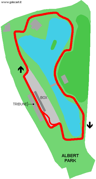
| Distinctive points | Aughtie Drive - Melford Corner - Ross Gregory Drive - Austin Healey Corner - Powerhouse Corner - Lakeside Drive - Lucas Corner - Albert Road Drive - Jaguar Corner | ||||
| length | 5027 m | 16494 ft | 3.124 mi | (6) | |
| length | 5027 m | 16494 ft | 3.124 mi | (5) | |
| length | 5083 m | 16675 ft | 3.158 mi | Calculated from aerial photo (*) | (2) |
| Melbourne, Albert Park | |||||
| Description | Project dated autumn 1994, nearly equal to definitve track used from 1996 for F.1 Australia GP. | ||||
| Years | 1994 | ||||
| Direction |  Clockwise Clockwise | ||||
| Proposal |
YES
| ||||
| Proposal not developed | YES | ||||
| Car Circuit | YES | ||||
| Motorbike circuit | |||||
| Type | Street course | ||||
| Inauguration | |||||
| Closing | |||||
| Last update of this page | September 24th 2007 | ||||
| Info last update | |||||
| Designer | |||||
| Distinctive points | |||||
| length | 5260 m | 17257 ft | 3.269 mi | (7) | |
| Melbourne, Albert Park | |||||
| Description | |||||
| Years | 1996÷2020 | ||||
| Direction | Clockwise | ||||
| Proposal |
NO | ||||
| No longer operational | YES | ||||
| Car Circuit | YES | ||||
| Motorbike circuit | |||||
| Type | Street course | ||||
| Inauguration | March 10th 1996 | ||||
| Closing | 2020 | ||||
| Last update of this page | February 25th 2021 | ||||
| Info last update | |||||
| Designer | |||||
| Distinctive points | Jones - Brabham - Aughtie Drive - Sports Centre - Hellas - Whiteford - Albert Road Drive - Marina - Lauda - Clark - Fittipaldi - Lakeside Drive - Waite - Hill - Ascari - Ross Gregory Drive - Stewart - Senna - Prost | ||||
| length | 5269 m | 17287 ft | 3.274 mi | (6) | |
| length | 5313 m | 17431 ft | 3.301 mi | Temporary unconfirmed track length, while waiting for new measuring systems (Spring 2000) | (8) |
| length | 5302 m | 17395 ft | 3.295 mi | Official track length until 1999 (in 2000 FIA changed measuring system) | (5) |
| length | 5303 m | 17398 ft | 3.295 mi | Official track length from 2000, when FIA changed measuring system (track unchanged) | (8) |
| length | 5303 m | 17398 ft | 3.295 mi | Official track length from 2000, when FIA changed measuring system (track unchanged) | (5) |
| length | 5307 m | 17412 ft | 3.298 mi | Calculated from aerial photo (*) | (2) |
| Melbourne, Albert Park | |||||
| Description | |||||
| Years | 2021÷... | ||||
| Direction | Clockwise | ||||
| Proposal |
YES
| ||||
| Proposal not developed | |||||
| Car Circuit | YES | ||||
| Motorbike circuit | |||||
| Type | Street course | ||||
| Inauguration | 2021 | ||||
| Closing | |||||
| Last update of this page | April 2nd 2021 | ||||
| Info last update | |||||
| Designer | |||||
| Distinctive points | |||||
| length | 5280 m | 17323 ft | 3.281 mi | (12) | |
Melbourne, Albert Park: compared layout
Due to technical problems, temporarily it’s no longer possible to see the circuits on Google Maps embedded in the current page.
This feature will be restored as soon as I figure out how to do (any help would be appreciated!)
See this track layout with Google Maps - Google Earth
(milermeter.com can be used in your browser, without installing anything; Google Earth is a program that must be installed in your computer)
(Map shown here above can show at the same time all eventual layouts drawn. If you want to see only some of them, please go to Google Maps or Google Earth, by clicking on its own link)
Melbourne, Albert Park 1953÷1958
Due to technical problems, temporarily it’s no longer possible to see the circuits on Google Maps embedded in the current page.
This feature will be restored as soon as I figure out how to do (any help would be appreciated!)
See this track layout with Google Maps - Google Earth
(milermeter.com can be used in your browser, without installing anything; Google Earth is a program that must be installed in your computer)
(Map shown here above can show at the same time all eventual layouts drawn. If you want to see only some of them, please go to Google Maps or Google Earth, by clicking on its own link)
Melbourne, Albert Park: 1994 proposal
Melbourne, Albert Park 1996÷...
Due to technical problems, temporarily it’s no longer possible to see the circuits on Google Maps embedded in the current page.
This feature will be restored as soon as I figure out how to do (any help would be appreciated!)
See this track layout with Google Maps - Google Earth
(milermeter.com can be used in your browser, without installing anything; Google Earth is a program that must be installed in your computer)
(Map shown here above can show at the same time all eventual layouts drawn. If you want to see only some of them, please go to Google Maps or Google Earth, by clicking on its own link)
| Updates | |||||||
| Date | Track layout | Years | Description by | Map by | Thanks to | Note | |
| April 2nd 2021 | 2021÷... | Guido de Carli | Update | Description | |||
| February 25th 2021 | 2021÷... | Guido de Carli | Update | Description without map | |||
| June 3rd 2011 | Guido de Carli | Roelard Smit | Roelard Smit | Update | Description with map | ||
| February 27th 2008 | Guido de Carli | whrphlio | Update | Photos (link) | |||
| August 4th 2005 | Guido de Carli | Update | Description | ||||
| December 29th 2003 | 1994 | Guido de Carli | Guido de Carli | New | Description with map | ||
| Not all eventual updates issued in last years are already visible in this list | |||||||
Webmaster:
Guido de Carli

(Italiano - English - Español)
HOME PAGE