 Visualizza questa pagina in Italiano
 HOME PAGE
|
Visualizza questa pagina in Italiano
|
HOME PAGE
|
Legend and translations |
| USA - UNITED STATES | |||||
| ALVIN CALLENDAR FIELD | |||||
| Description | |||||
| Location | New Orleans LA - Louisiana - Southern States | ||||
| Location | South Eastern Noe Orleans downtown | ||||
| Latitude - Longitude | + 29°50'53" - 90°00'19" 29.848056 -90.005278 | ||||
| UTM Coordinates | X = 789339.95 - Y = 3305714.499 - Zone 15R | ||||
| Aerial photo / Map (*) |  Google Maps - Bing Maps - Flash Earth - Microsoft Research Maps - MapQuest Google Maps - Bing Maps - Flash Earth - Microsoft Research Maps - MapQuest | ||||
| Altitude AMSL | 1 m - 3 ft | ||||
| Inauguration | |||||
| Closing | |||||
| Designer | |||||
| Sources and links (Translation) (**) |
| ||||
| Alvin Callendar Field | |||||
| Description | |||||
| Years | |||||
| Direction |  Clockwise Clockwise | ||||
 Proposal Proposal |
NO | ||||
| No longer operational | |||||
| Car Circuit | |||||
| Motorbike circuit | |||||
| Type | Airfield course | ||||
| Inauguration | |||||
| Closing | |||||
| Last update of this page | December 27th 2006 | ||||
| Info last update | |||||
| Designer | |||||
| Distinctive points | |||||
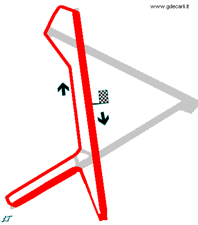
| length | 4506 m | 14784 ft | 2.8 mi | ||
Alvin Callendar Field
| Updates | |||||||
| Date | Track layout | Years | Description by | Map by | Thanks to | Note | |
| May 3rd 2003 | Guido de Carli | New | Description | ||||
| Not all eventual updates issued in last years are already visible in this list | |||||||
Webmaster:
Guido de Carli

(Italiano - English - Español)
HOME PAGE