 Visualizza questa pagina in Italiano
 HOME PAGE
|
Visualizza questa pagina in Italiano
|
HOME PAGE
|
Legend and translations |
| SWE - SWEDEN | |||||||||||||||||||||||||||||||||||||||||
| KARLSKOGA, GELLERåSEN | |||||||||||||||||||||||||||||||||||||||||
| SORRY, SOME DATA ARE NOT TRANSLATED YET | |||||||||||||||||||||||||||||||||||||||||
| Description | |||||||||||||||||||||||||||||||||||||||||
| Location | Karlskoga T - Örebro - Östra Mellansverige | ||||||||||||||||||||||||||||||||||||||||
| Location | 250 km from Stockholm, near to Karlstad, Kristineham and Örebro | ||||||||||||||||||||||||||||||||||||||||
| Latitude - Longitude | + 59°23'00" + 14°30'58" 59.383333 14.516111 | ||||||||||||||||||||||||||||||||||||||||
| UTM Coordinates | X = 472509.244 - Y = 6582837.539 - Zone 33V | ||||||||||||||||||||||||||||||||||||||||
| Aerial photo / Map (*) |  Google Maps - Bing Maps - Flash Earth - Eniro Google Maps - Bing Maps - Flash Earth - Eniro | ||||||||||||||||||||||||||||||||||||||||
| Altitude AMSL | 119 m - 390 ft | ||||||||||||||||||||||||||||||||||||||||
| Inauguration | 1949 | ||||||||||||||||||||||||||||||||||||||||
| Closing | |||||||||||||||||||||||||||||||||||||||||
| Designer | |||||||||||||||||||||||||||||||||||||||||
| Sources and links (Translation) (**) |
| ||||||||||||||||||||||||||||||||||||||||
| Karlskoga, Gelleråsen | |||||
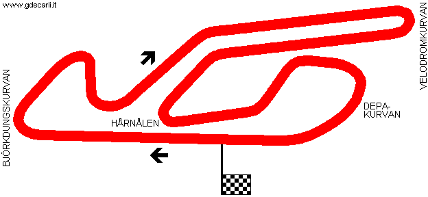
| Description | Road circuit opened in 1949 as a dirt track. In 1952 it was modified and asphalted. New changes were made on 1953 and finally in 1958, when it had layout shown in my map. On August 8th 1970 five spectators died after a crash at Velodromkurvan and the track was closed. In 1973 it was reopened with different layout | ||||
| Years | 1958÷1970 | ||||
| Direction |  Clockwise Clockwise | ||||
 Proposal Proposal |
NO | ||||
| No longer operational | YES | ||||
| Car Circuit | YES | ||||
| Motorbike circuit | |||||
| Type | Permanent | ||||
| Inauguration | |||||
| Closing | 1970 | ||||
| Last update of this page | September 7th 2007 | ||||
| Info last update | |||||
| Designer | |||||
| Distinctive points | Björkdungskurvan - Velodromkurvan - Hårnålen - Depakurvan | ||||
| length | 3000 m | 9843 ft | 1.864 mi | (1) | |
| Karlskoga, Gelleråsen | |||||
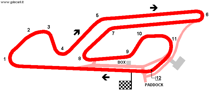
| Description | The track was reopend in 1973, after three years. My map shows layout used for weden motorbike GP on July 22nd 1979: I don’t know if from 1973 to 1979 the track was modified or if it was unchanged (as I think, even if I have no evidence). After 1978 GP, bikers asked to do some changes to track facilities and to remove banking on hairpin 6. These changes should have been done within 1979 GP, but they weren’t and bikers asked again for 1980 GP, that was never raced. I don’t know when this layout was used for the last time. After Mantorp Park was closed because of economical reasons, Karlkoga organizers offered to lengthen the track (approx. 1 km longer) in order to host F.1 Sweden GP, I think alternating with Anderstorp. This proposal was never developed. I have no more info. | ||||
| Years | 1973÷... | ||||
| Direction | Clockwise | ||||
| Proposal |
NO | ||||
| No longer operational | |||||
| Car Circuit | |||||
| Motorbike circuit | YES | ||||
| Type | Permanent | ||||
| Inauguration | |||||
| Closing | |||||
| Last update of this page | September 7th 2007 | ||||
| Info last update | |||||
| Designer | |||||
| Distinctive points | Björkdungskurvan - Velodromkurvan - Hårnålen - Depakurvan | ||||
| length | 3150 m | 10335 ft | 1.957 mi | (9) | |
| Karlskoga, Gelleråsen | |||||
| Description | |||||
| Years | 1971÷... | ||||
| Direction | Clockwise | ||||
| Proposal |
NO | ||||
| No longer operational | YES | ||||
| Car Circuit | |||||
| Motorbike circuit | |||||
| Type | Permanent | ||||
| Inauguration | |||||
| Closing | |||||
| Last update of this page | September 7th 2007 | ||||
| Info last update | |||||
| Designer | |||||
| Distinctive points | Björkdungskurvan - Velodromkurvan - Hårnålen - Depakurvan | ||||
| length | 2530 m | 8301 ft | 1.572 mi | ||
| length | 2530 m | 8301 ft | 1.572 mi | (5) | |
Karlskoga, Gelleråsen 1958÷1970
Karlskoga, Gelleråsen 1973÷...
| Updates | |||||||
| Date | Track layout | Years | Description by | Map by | Thanks to | Note | |
| May 13th 2013 | Guido de Carli | micap | Update | Description | |||
| September 21st 2005 | Guido de Carli | Update | Description | ||||
| March 10th 2005 | 1973÷... | Guido de Carli | Update | Description | |||
| October 29th 2004 | 1958÷1970 | Guido de Carli | Guido de Carli | Update | Description with map | ||
| March 10th 2004 | 1958÷1970 | Guido de Carli | Guido de Carli | Update | Description with map | ||
| October 3rd 2002 | Guido de Carli | New | Description | ||||
| Not all eventual updates issued in last years are already visible in this list | |||||||
Webmaster:
Guido de Carli

(Italiano - English - Español)
HOME PAGE