 Visualizza questa pagina in Italiano
 HOME PAGE
|
Visualizza questa pagina in Italiano
|
HOME PAGE
|
Legend and translations |
| SUI - SWITZERLAND | |||||||||||||||||
| SION | |||||||||||||||||
| SORRY, SOME DATA ARE NOT TRANSLATED YET | |||||||||||||||||
| Description | At the end of 1983 a permanent circuit was proposed. It should have been built in the former Sion airport and its trubunes should have hosted up to 120,000 spectators. The proposal was seen also by Didier Pironi e Jean-Pierre Jabouille, who gave some advices. The biggest problem is about the law: races on circuits were banned in Switzerland in 1955, so before doing anything this law should have been canceled. This proposal was definitively rejected on September 13th 1984 by Swiss Federal Council, because - they declared - a GP would frustrate years of effort for improving safety and education of the roads Wolfpd wrote on racingcircuits.net forum that tha eirfield is still in use (2005) both for military and commercial flights and that the airfield looks a little bit different than on this map. Possibly it was modified later. | ||||||||||||||||
| Location | Sion / Sitten VS - Valais / Wallis - Région Lémanique | ||||||||||||||||
| Location | former Sion airport | ||||||||||||||||
| Latitude - Longitude | + 46°13'09" + 7°19'37" 46.219167 7.326944 | ||||||||||||||||
| UTM Coordinates | X = 370964.601 - Y = 5119759.296 - Zone 32T | ||||||||||||||||
| Swiss national coordinates | Y = 591381 - X = 118642 | ||||||||||||||||
| Aerial photo / Map (*) |  Google Maps - Bing Maps - Flash Earth - map.search.ch Google Maps - Bing Maps - Flash Earth - map.search.ch | ||||||||||||||||
| Altitude AMSL | 485 m - 1591 ft | ||||||||||||||||
| Inauguration | |||||||||||||||||
| Closing | |||||||||||||||||
| Designer | |||||||||||||||||
| Sources and links (Translation) (**) |
| ||||||||||||||||
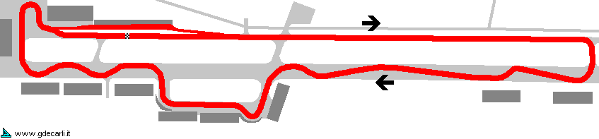
| Sion | |||||
| Description | |||||
| Years | 1984 | ||||
| Direction |  Clockwise Clockwise | ||||
 Proposal Proposal |
YES
| ||||
| Proposal not developed | YES | ||||
| Car Circuit | YES | ||||
| Motorbike circuit | |||||
| Type | Airfield course | ||||
| Inauguration | |||||
| Closing | |||||
| Last update of this page | October 15th 2005 | ||||
| Info last update | September 1984 | ||||
| Designer | |||||
| Distinctive points | |||||
| length | 3400 m | 11155 ft | 2.113 mi | (3) | |
Sion
| Updates | |||||||
| Date | Track layout | Years | Description by | Map by | Thanks to | Note | |
| October 15th 2005 | 1984 | Guido de Carli | Wolfpd | Update | Description | ||
| August 15th 2005 | 1984 | Guido de Carli | Update | Description | |||
| August 4th 2005 | 1984 | Guido de Carli | Guido de Carli | New | Description with map | ||
| Not all eventual updates issued in last years are already visible in this list | |||||||
Webmaster:
Guido de Carli

(Italiano - English - Español)
HOME PAGE