 Visualizza questa pagina in Italiano
 HOME PAGE
|
Visualizza questa pagina in Italiano
|
HOME PAGE
|
Legend and translations |
| SLO - SLOVENIA | |||||||||||||||||||||
| MOBIKROG (NOVO MESTO) | |||||||||||||||||||||
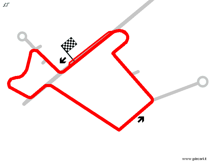
| Description | Track created in a disused military. It uses some existing roads that connected airport to a missile base just outside the airport perimeter. Some parts of the track have been built from scratch in order to reach at least the length of 2 km. Located in an unusual setting, surrounded by stone huts, ruin of the Cold War, even with an incredible passage of the track under the remains of one of them (see this photo). The track hosted a race of Euro STC on October 8th 2000, replacing the event that should have been hosted at Mobitrack, the new circuit (never built) around Ljubljana. In summer 2007 it is still active. January 2009: it seems has been removed a section of track, but I have no evidence of this. June 2012: the circuit was dismantled, because the military base was reactivated. Hardly the circuit will be used again | ||||||||||||||||||||
| Location | Cerklje ob Krki - Jugovzhodna Slovenija | ||||||||||||||||||||
| Location | Approx 2.5 km - 1.5 mi South West of Cerklje ob Krki military airfield, 30 km - 16,5 mi North East of Novo Mesto and 40 km - 25 mi North West of Zagreb (Croatia) | ||||||||||||||||||||
| Latitude - Longitude | + 45°53'25" + 15°29'47" 45.890278 15.496389 | ||||||||||||||||||||
| UTM Coordinates | X = 538512.438 - Y = 5081976.529 - Zone 33T | ||||||||||||||||||||
| Aerial photo / Map (*) |  Google Maps - Bing Maps - Flash Earth - Geopedia.si Google Maps - Bing Maps - Flash Earth - Geopedia.si | ||||||||||||||||||||
| Altitude AMSL | 167 m - 548 ft | ||||||||||||||||||||
| Inauguration | 2000 | ||||||||||||||||||||
| Closing | |||||||||||||||||||||
| Designer | |||||||||||||||||||||
| Sources and links (Translation) (**) |
| ||||||||||||||||||||
| Mobikrog (Novo Mesto) | |||||
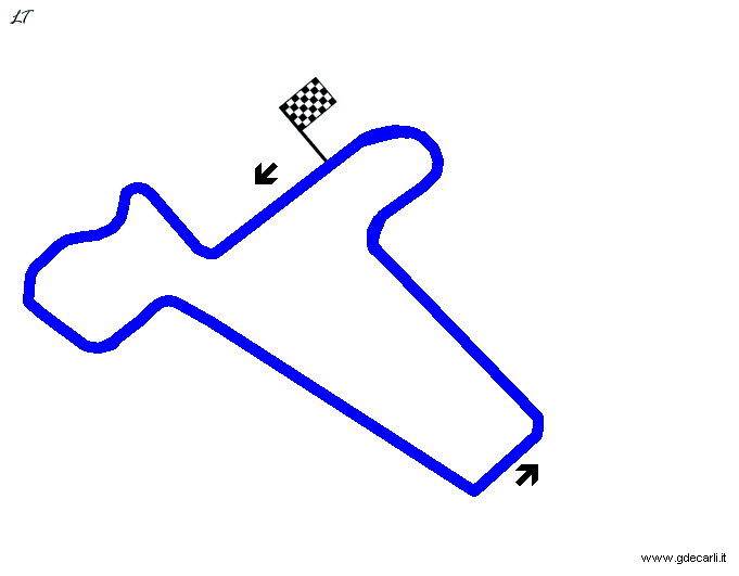
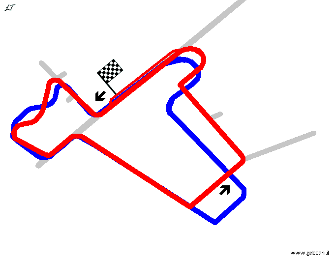
| Description | Note: most of the maps shown on web are wrong (just compare them with an aerial photo). The track has the straights shortes, while section built just after the finish line is different. On this page are shown both layouts | ||||
| Years | 2000÷... | ||||
| Direction |  Anticlockwise Anticlockwise | ||||
 Proposal Proposal |
NO | ||||
| No longer operational | YES | ||||
| Car Circuit | YES | ||||
| Motorbike circuit | |||||
| Type | Airfield course | ||||
| Inauguration | |||||
| Closing | |||||
| Last update of this page | September 2nd 2012 | ||||
| Info last update | |||||
| Designer | |||||
| Distinctive points | |||||
| length | 2005 m | 6578 ft | 1.246 mi | ||
Mobikrog: exact layout
| Updates | |||||||
| Date | Track layout | Years | Description by | Map by | Thanks to | Note | |
| September 2nd 2012 | Guido de Carli | Andrea Bevilacqua | Update | Description | |||
| January 15th 2009 | 2000÷... | Guido de Carli | David Griac (jpm) | Update | Description | ||
| July 9th 2007 | 2000÷... | Lorenzo Tommasi | Lorenzo Tommasi | Update | Description with map | ||
| March 26th 2003 | 2000÷... | Guido de Carli | New | Description without map | |||
| Not all eventual updates issued in last years are already visible in this list | |||||||
Webmaster:
Guido de Carli

(Italiano - English - Español)
HOME PAGE