 Visualizza questa pagina in Italiano
 HOME PAGE
|
Visualizza questa pagina in Italiano
|
HOME PAGE
|
Legend and translations |
| RSA - SOUTH AFRICA | |||||||||||||||||
| PIETERMARITZBURG, ROY HESKETH | |||||||||||||||||
| Not to be confused with | Pietermaritzburg, Alexandra Park | ||||||||||||||||
| Description | |||||||||||||||||
| Location | Pietermaritzburg - KwaZulu-Natal | ||||||||||||||||
| Location | 3 km from Pietermaritzburg and 87 from Durban, on the road N3 to Johannesburg, in Natal | ||||||||||||||||
| Latitude - Longitude | - 29°37'17" + 30°25'26" -29.621389 30.423889 | ||||||||||||||||
| UTM Coordinates | X = 250559.054 - Y = 6720393.758 - Zone 36J | ||||||||||||||||
| Aerial photo / Map (*) |  Google Maps - Bing Maps - Flash Earth Google Maps - Bing Maps - Flash Earth | ||||||||||||||||
| Altitude AMSL | 708 m - 2323 ft | ||||||||||||||||
| Inauguration | December 1953 | ||||||||||||||||
| Closing | |||||||||||||||||
| Designer | |||||||||||||||||
| Sources and links (Translation) (**) |
| ||||||||||||||||
| Roy Hesketh Circuit | |||||
| Description | |||||
| Years | 1953÷1961 | ||||
| Direction |  Anticlockwise Anticlockwise | ||||
 Proposal Proposal |
NO | ||||
| No longer operational | YES | ||||
| Car Circuit | YES | ||||
| Motorbike circuit | |||||
| Type | Permanent | ||||
| Inauguration | December 1953 | ||||
| Closing | November 1961 | ||||
| Last update of this page | December 9th 2010 | ||||
| Info last update | |||||
| Designer | |||||
| Distinctive points | |||||
| length | 2575 m | 8448 ft | 1.6 mi | (4) | |
| Roy Hesketh Circuit | |||||
| Description | The circuit was extended, by adding BP Send section | ||||
| Years | 1962÷1981 | ||||
| Direction | Anticlockwise | ||||
| Proposal |
NO | ||||
| No longer operational | YES | ||||
| Car Circuit | YES | ||||
| Motorbike circuit | |||||
| Type | Permanent | ||||
| Inauguration | 1962 | ||||
| Closing | November 1981 | ||||
| Last update of this page | December 9th 2010 | ||||
| Info last update | |||||
| Designer | |||||
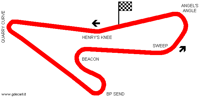
| Distinctive points | Henry’s Knee - Quarry Curve - BP Send - Beacon - Sweep - Angel’s Angle | ||||
| length | 2902 m | 9520 ft | 1.803 mi | (1) | |
| length | 2902 m | 9520 ft | 1.803 mi | (4) | |
| Width | 10 m | 33 ft | (1) | ||
| Roy Hesketh Circuit | |||||
| Description | |||||
| Years | |||||
| Direction | |||||
| Proposal |
NO | ||||
| No longer operational | |||||
| Car Circuit | YES | ||||
| Motorbike circuit | |||||
| Type | Permanent | ||||
| Inauguration | |||||
| Closing | |||||
| Last update of this page | October 20th 2010 | ||||
| Info last update | |||||
| Designer | |||||
| Distinctive points | |||||
Roy Hesketh Circuit, 1962÷1981
| Updates | |||||||
| Date | Track layout | Years | Description by | Map by | Thanks to | Note | |
| December 9th 2010 | Guido de Carli | Paddy Ewer | Update | Description | |||
| October 20th 2010 | Roy Hesketh Circuit | Guido de Carli | David Griac (jpm) | Update | Description | ||
| March 21st 2004 | Roy Hesketh Circuit | 1962÷1981 | Guido de Carli | Guido de Carli | New | Description with map | |
| Not all eventual updates issued in last years are already visible in this list | |||||||
Webmaster:
Guido de Carli

(Italiano - English - Español)
HOME PAGE