 Visualizza questa pagina in Italiano
 HOME PAGE
|
Visualizza questa pagina in Italiano
|
HOME PAGE
|
Legend and translations |
| RSA - SOUTH AFRICA | |||||||||||||||||||||
| KILLARNEY | |||||||||||||||||||||
| Description | |||||||||||||||||||||
| Location | Cape Town - Western Cape | ||||||||||||||||||||
| Location | 8 km from Cape Town and 8 km from Belville-Paarl | ||||||||||||||||||||
| Latitude - Longitude | - 33°49'28" + 18°31'38" -33.824444 18.527222 | ||||||||||||||||||||
| UTM Coordinates | X = 271148.384 - Y = 6254559.058 - Zone 34H | ||||||||||||||||||||
| Aerial photo / Map (*) |  Google Maps - Bing Maps - Flash Earth Google Maps - Bing Maps - Flash Earth | ||||||||||||||||||||
| Altitude AMSL | 14 m - 46 ft | ||||||||||||||||||||
| Inauguration | |||||||||||||||||||||
| Closing | |||||||||||||||||||||
| Designer | |||||||||||||||||||||
| Sources and links (Translation) (**) |
| ||||||||||||||||||||
| Killarney | |||||
| Description | |||||
| Years | |||||
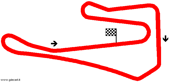
| Direction |  Clockwise Clockwise | ||||
 Proposal Proposal |
NO | ||||
| No longer operational | |||||
| Car Circuit | YES | ||||
| Motorbike circuit | |||||
| Type | Permanent | ||||
| Inauguration | |||||
| Closing | |||||
| Last update of this page | March 7th 2006 | ||||
| Info last update | |||||
| Designer | |||||
| Distinctive points | Hoal’s Hook (Conti) - Quarry (Engen) - Damps Dip (Shell) - Tygerberg Straight - Malmesbury Sweep (Sabat) - Killarney Straight - Cape Town (Vodacom) | ||||
| length | 3267 m | 10719 ft | 2.03 mi | (2) | |
| Min width | 7.4 m | 24 ft | (1) | ||
Killarney
| PHOTOS |
| All photos were taken in October 2004 by Yves-Henri Randier, reproduced here with author’s descriprion with kind permission. |
| Photos by Yves-Henri Randier - October 2004 |
| Click on thumbnail to open original large photo |
| 1 | 2 | 3 | 4 |
 |  |  |  |
| Overall plan of the track and premises | From the Engen Boma looking right to Shell Corner towards Oval Corner with Table Mountain in the background | From the Engen Boma looking straight ahead to Conti and the starting grid with Table Mountain still behind | From the pits towards Vodacom Corner with view of the Drag line on the left.... with Table Mountain again |
| 5 | 6 | ||
 |  | ||
| Extra shot with pitbabes | Extra shot with pitbabes |
| Updates | |||||||
| Date | Track layout | Years | Description by | Map by | Thanks to | Note | |
| March 7th 2006 | Guido de Carli | Yves-Henri Randier | New | Photos (on this site) | |||
| September 21st 2005 | Guido de Carli | Update | Description | ||||
| February 26th 2004 | Guido de Carli | New | Photos (link) | ||||
| February 26th 2004 | Guido de Carli | Guido de Carli | New | Description with map | |||
| July 12th 2003 | Guido de Carli | New | Description | ||||
| September 16th 2002 | Guido de Carli | New | Description | ||||
| Not all eventual updates issued in last years are already visible in this list | |||||||
Webmaster:
Guido de Carli

(Italiano - English - Español)
HOME PAGE