 Visualizza questa pagina in Italiano
 HOME PAGE
|
Visualizza questa pagina in Italiano
|
HOME PAGE
|
Legend and translations |
| ITA - ITALY | |||||||||||||||||||||
| CIRCUITO DELLE TRE PROVINCE (EMILIA/TOSCANA) | |||||||||||||||||||||
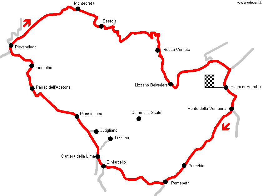
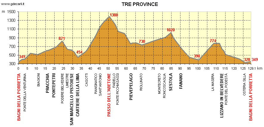
| Description | Street circuit used from 1929 to 1931. It was divided into three different provinces (Bologna, Pistoia, Modena), and this is the reason of its name. Map is drawn using an original road map dated 1927 and profile is taken from a guide dated 1929. On these roads in 1987 Lima-Abetone hillclimb was organized. It should have been raced on August 30th on a 12 km track, but few days before the race Prefetto of Pistoia (local autorithy about public safety) didn’t allow the race because of safety of spectators. | ||||||||||||||||||||
| Location | Bagni della Porretta BO - Bologna - Emilia Romagna | ||||||||||||||||||||
| Location | On Appennino Tosco-Emiliano, mountains that divide Emilia and Toscana. Bologna is about 100 km - 62 mi North-East from Bagni di Porretta (today Porretta Terme), Florence about 80 km - 50 mi South-East. | ||||||||||||||||||||
| Latitude - Longitude | + 44°09'29" + 10°58'31" 44.158056 10.975278 | ||||||||||||||||||||
| UTM Coordinates | X = 657946.108 - Y = 4891325.076 - Zone 32T | ||||||||||||||||||||
| Aerial photo / Map (*) |  Google Maps - Bing Maps - Flash Earth - Portale Cartografico Nazionale - Visual Pagine Gialle Google Maps - Bing Maps - Flash Earth - Portale Cartografico Nazionale - Visual Pagine Gialle | ||||||||||||||||||||
| Altitude AMSL | 1388 m - 4554 ft | ||||||||||||||||||||
| Inauguration | 1929 | ||||||||||||||||||||
| Closing | 1931 | ||||||||||||||||||||
| Designer | |||||||||||||||||||||
| Sources and links (Translation) (**) |
| ||||||||||||||||||||
| Circuito delle Tre Province | |||||
| Description | |||||
| Years | 1929÷1931 | ||||
| Direction |  Clockwise Clockwise | ||||
 Proposal Proposal |
NO | ||||
| No longer operational | YES | ||||
| Car Circuit | YES | ||||
| Motorbike circuit | |||||
| Type | Road course | ||||
| Inauguration | 1929 | ||||
| Closing | 1931 | ||||
| Last update of this page | September 12th 2007 | ||||
| Info last update | |||||
| Designer | |||||
| Distinctive points | Bagni di Porretta - Ponte della Venturina - Molino del Pallone - Pracchia - Cutigliano - Passo dell’Abetone - Pievepelago - Sestola - Fanano - Lizzano in Belvedere - Bagni di Porretta | ||||
| length | 128.5 km | 79.848 mi | (3) | ||
Circuito delle Tre Province (Emilia/Toscana)

| DETAIL | |||||||||||||||||||||||||||||||||||||||||||||||||||||||||||||||||||||||||||||||||||||||||||||||||||||||||||||||||||||||||||||||||||||||||||||||||||||||||||||||||||||||||||||||||||||||||||||||||||||||||||||||||||||||||||||||||||||||||||||||||||||||||||||||||||||||||||||||||||||||||||||||||||||||||||||||||||||||||||||||||||
| |||||||||||||||||||||||||||||||||||||||||||||||||||||||||||||||||||||||||||||||||||||||||||||||||||||||||||||||||||||||||||||||||||||||||||||||||||||||||||||||||||||||||||||||||||||||||||||||||||||||||||||||||||||||||||||||||||||||||||||||||||||||||||||||||||||||||||||||||||||||||||||||||||||||||||||||||||||||||||||||||||
| Updates | |||||||
| Date | Track layout | Years | Description by | Map by | Thanks to | Note | |
| January 24th 2004 | Guido de Carli | Update | Description | ||||
| August 9th 2003 | Guido de Carli | Guido de Carli | New | Description with map | |||
| Not all eventual updates issued in last years are already visible in this list | |||||||
Webmaster:
Guido de Carli

(Italiano - English - Español)
HOME PAGE