 Visualizza questa pagina in Italiano
 HOME PAGE
|
Visualizza questa pagina in Italiano
|
HOME PAGE
|
Legend and translations |
| ITA - ITALY | |||||||||||||||||||||||||||||||||
| SPOLETO | |||||||||||||||||||||||||||||||||
| SORRY, SOME DATA ARE NOT TRANSLATED YET | |||||||||||||||||||||||||||||||||
| Not to be confused with | Spoleto (minimoto) - Spoleto, Due Mondi | ||||||||||||||||||||||||||||||||
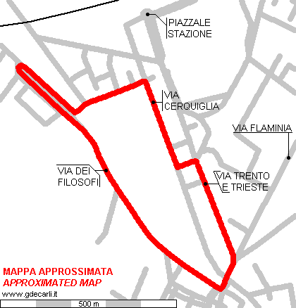
| Description | Street circuit used on May 29th 1966 for 11th edition of Coppa Città di Spoleto (Spoleto City Cup), a motorbike race. I don’t know neither if previous 10 editions were run on the same track, nor if there has been any more races on following years. I draw this map by trying to recall map on official race program; it could be slightly diffent. Unfortunately I don’t recall neither track direction nor start/finish position | ||||||||||||||||||||||||||||||||
| Location | Spoleto PG - Perugia - Umbria | ||||||||||||||||||||||||||||||||
| Location | |||||||||||||||||||||||||||||||||
| Latitude - Longitude | + 42°44'37" + 12°44'07" 42.743611 12.735278 | ||||||||||||||||||||||||||||||||
| UTM Coordinates | X = 314636.708 - Y = 4734830.98 - Zone 33T | ||||||||||||||||||||||||||||||||
| Aerial photo / Map (*) |  Google Maps - Bing Maps - Flash Earth - Portale Cartografico Nazionale - Visual Pagine Gialle Google Maps - Bing Maps - Flash Earth - Portale Cartografico Nazionale - Visual Pagine Gialle | ||||||||||||||||||||||||||||||||
| Altitude AMSL (approx) | 360 m - 1181 ft (approx) | ||||||||||||||||||||||||||||||||
| Inauguration | 1935 | ||||||||||||||||||||||||||||||||
| Closing | May 13th 1973 | ||||||||||||||||||||||||||||||||
| Designer | |||||||||||||||||||||||||||||||||
| Sources and links (Translation) (**) |
| ||||||||||||||||||||||||||||||||
| Spoleto | |||||
| Same circuit? | |||||
| Description | |||||
| Years | 1935, 1939, 1947÷1954, 1965÷1973 | ||||
| Direction | |||||
 Proposal Proposal |
NO | ||||
| No longer operational | YES | ||||
| Car Circuit | |||||
| Motorbike circuit | YES | ||||
| Type | Street course | ||||
| Inauguration | 1935 | ||||
| Closing | May 13th 1973 | ||||
| Last update of this page | October 27th 2020 | ||||
| Info last update | |||||
| Designer | |||||
| Distinctive points | via dei Filosofi - via Cerquiglia - via Trento e Trieste | ||||
| length | 2300 m | 7546 ft | 1.429 mi | ||
| length | 2300 m | 7546 ft | 1.429 mi | (1) | |
1966 layout (approximated map)
| Updates | |||||||
| Date | Track layout | Years | Description by | Map by | Thanks to | Note | |
| October 27th 2020 | Guido de Carli | Update | Description | ||||
| January 13th 2005 | Guido de Carli | Update | Description | ||||
| September 27th 2003 | Guido de Carli | Guido de Carli | New | Description with map | |||
| Not all eventual updates issued in last years are already visible in this list | |||||||
Webmaster:
Guido de Carli

(Italiano - English - Español)
HOME PAGE