 Visualizza questa pagina in Italiano
 HOME PAGE
|
Visualizza questa pagina in Italiano
|
HOME PAGE
|
Legend and translations |
| ITA - ITALY | |||||||||
| LIDO DI OSTIA | |||||||||
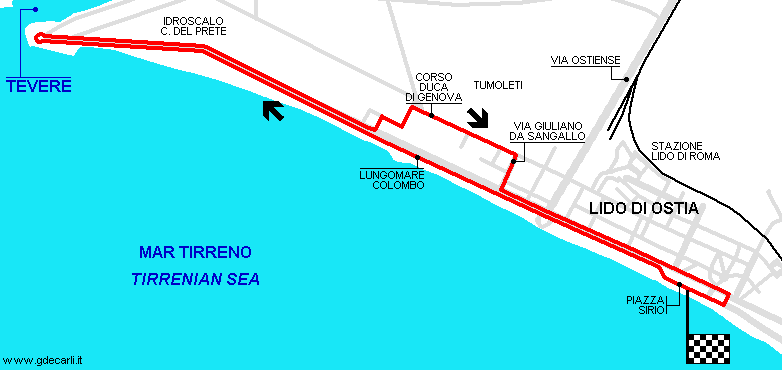
| Description | Street circuit used for 1st Circuito dell’Impero (Empire Circuit) on June 11th 1939. I don’t know if it had some section in common with Circuito Ostiense used in 1926 (I know nothing about it) | ||||||||
| Location | Lido di Ostia RM - Roma - Lazio | ||||||||
| Location | Lido di Ostia (Roma), at Tevere mouth and close to former Carlo Del Prete flying boat terminal. This area had been completely modified and now it’s not far from Fiumicino International Airport. Castelfusano circuit is few km East. | ||||||||
| Latitude - Longitude | + 41°43'46" + 12°16'32" 41.729444 12.275556 | ||||||||
| UTM Coordinates | X = 273404.899 - Y = 4623324.751 - Zone 33T | ||||||||
| Aerial photo / Map (*) |  Google Maps - Bing Maps - Flash Earth - Portale Cartografico Nazionale - Visual Pagine Gialle Google Maps - Bing Maps - Flash Earth - Portale Cartografico Nazionale - Visual Pagine Gialle | ||||||||
| Altitude AMSL | |||||||||
| Inauguration | June 11th 1939 | ||||||||
| Closing | June 11th 1939 | ||||||||
| Designer | |||||||||
| Sources and links (Translation) (**) |
| ||||||||
| Circuito dell’Impero | |||||
| Description | |||||
| Years | 1939 | ||||
| Direction |  Clockwise Clockwise | ||||
 Proposal Proposal |
NO | ||||
| No longer operational | YES | ||||
| Car Circuit | YES | ||||
| Motorbike circuit | |||||
| Type | Street course | ||||
| Inauguration | June 11th 1939 | ||||
| Closing | June 11th 1939 | ||||
| Last update of this page | April 4th 2006 | ||||
| Info last update | |||||
| Designer | |||||
| Distinctive points | |||||
| length | 10132 m | 33241 ft | 6.296 mi | ||
| length | 10100 m | 33136 ft | 6.276 mi | (1) | |
Lido di Ostia
| Updates | |||||||
| Date | Track layout | Years | Description by | Map by | Thanks to | Note | |
| May 2nd 2004 | Circuito dell’Impero | 1939 | Guido de Carli | Guido de Carli | New | Description with map | |
| July 2nd 2003 | Circuito dell’Impero | 1939 | Guido de Carli | New | Description | ||
| Not all eventual updates issued in last years are already visible in this list | |||||||
Webmaster:
Guido de Carli

(Italiano - English - Español)
HOME PAGE