 Visualizza questa pagina in Italiano
 HOME PAGE
|
Visualizza questa pagina in Italiano
|
HOME PAGE
|
Legend and translations |
| ITA - ITALY | |||||||||||||
| CANDIANA | |||||||||||||
| Description | A regional law dated 1999 in Veneto finances construction of a new circuit log at least 3.5 km. This is the list of 13 proposals::
Today (November 2003) I think they haven’t made any work yet | ||||||||||||
| Location | Candiana PD - Padova - Veneto | ||||||||||||
| Location | |||||||||||||
| Latitude - Longitude (approx) | + 45°13'00" + 11°58'00" (approx) 45.216667 11.966667 (approx) | ||||||||||||
| UTM Coordinates (approx) | X = 732935.173 - Y = 5011302.015 - Zone 32T (approx) | ||||||||||||
| Aerial photo / Map (*) |  Google Maps - Bing Maps - Flash Earth - Portale Cartografico Nazionale - Visual Pagine Gialle Google Maps - Bing Maps - Flash Earth - Portale Cartografico Nazionale - Visual Pagine Gialle | ||||||||||||
| Altitude AMSL | |||||||||||||
| Inauguration | |||||||||||||
| Closing | |||||||||||||
| Designer | |||||||||||||
| Sources and links (Translation) (**) |
| ||||||||||||
| Candiana | |||||
| Full circuit | |||||
| Description | |||||
| Years | |||||
| Direction |  Anticlockwise Anticlockwise | ||||
 Proposal Proposal |
YES
| ||||
| Proposal not developed | YES | ||||
| Car Circuit | |||||
| Motorbike circuit | |||||
| Type | Permanent | ||||
| Inauguration | |||||
| Closing | |||||
| Last update of this page | June 14th 2003 | ||||
| Info last update | March 2000 | ||||
| Designer | |||||
| Distinctive points | |||||
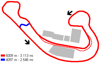
| length | 5009 m | 16434 ft | 3.113 mi | Long circuit | |
| length | 4097 m | 13442 ft | 2.546 mi | Short circuit | |
Long course

| Updates | |||||||
| Date | Track layout | Years | Description by | Map by | Thanks to | Note | |
| November 7th 2003 | Guido de Carli | New | Description without map | ||||
| Not all eventual updates issued in last years are already visible in this list | |||||||
Webmaster:
Guido de Carli

(Italiano - English - Español)
HOME PAGE