 Visualizza questa pagina in Italiano
 HOME PAGE
|
Visualizza questa pagina in Italiano
|
HOME PAGE
|
Legend and translations |
| ARG - ARGENTINA | |||||
| PLACIDO RUIZ | |||||
| Description | Circuit built in horse track | ||||
| Location | Santa Fé S - Santa Fé - Centro | ||||
| Location | |||||
| Latitude - Longitude (approx) | - 31°38'00" - 60°42'00" (approx) -31.633333 -60.7 (approx) | ||||
| UTM Coordinates (approx) | X = 718133.944 - Y = 6497908.341 - Zone 20J (approx) | ||||
| Aerial photo / Map (*) |  Google Maps - Bing Maps - Flash Earth Google Maps - Bing Maps - Flash Earth | ||||
| Altitude AMSL (approx) | 20 m - 66 ft (approx) | ||||
| Inauguration | |||||
| Closing | |||||
| Designer | |||||
| Sources and links (Translation) (**) |
| ||||
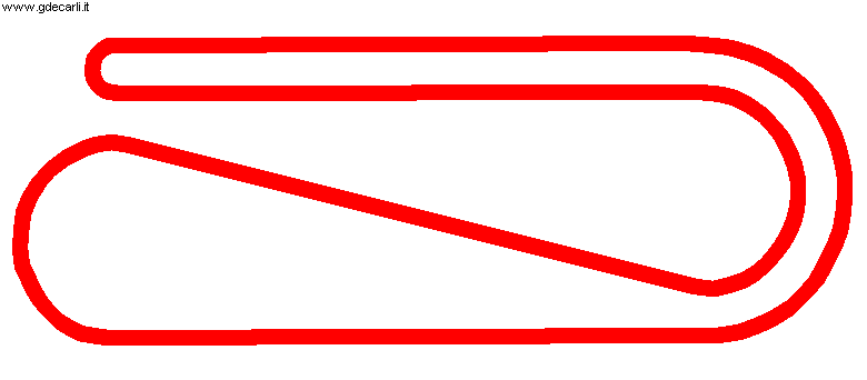
| Circuito Placido Ruiz | |||||
| Description | |||||
| Years | |||||
| Direction | |||||
 Proposal Proposal |
NO | ||||
| No longer operational | YES | ||||
| Car Circuit | |||||
| Motorbike circuit | |||||
| Type | Courses established on or around horse track venues | ||||
| Inauguration | |||||
| Closing | |||||
| Last update of this page | October 4th 2010 | ||||
| Info last update | |||||
| Designer | |||||
| Distinctive points | |||||
Placido Ruiz
| Updates | |||||||
| Date | Track layout | Years | Description by | Map by | Thanks to | Note | |
| October 4th 2010 | Circuito Placido Ruiz | Guido de Carli | Guido de Carli | New | Description with map | ||
| Not all eventual updates issued in last years are already visible in this list | |||||||
Webmaster:
Guido de Carli

(Italiano - English - Español)
HOME PAGE