 Visualizza questa pagina in Italiano
 HOME PAGE
|
Visualizza questa pagina in Italiano
|
HOME PAGE
|
Legend and translations |
| ARG - ARGENTINA | |||||||||||||||||||||||||||||
| OBERá | |||||||||||||||||||||||||||||
| Description | |||||||||||||||||||||||||||||
| Location | Oberá N - Misiones - Norte Grande Argentino | ||||||||||||||||||||||||||||
| Location | |||||||||||||||||||||||||||||
| Latitude - Longitude | - 27°29'35" - 55°10'40" -27.493056 -55.177778 | ||||||||||||||||||||||||||||
| UTM Coordinates | X = 680014.46 - Y = 6957630.581 - Zone 21J | ||||||||||||||||||||||||||||
| Aerial photo / Map (*) |  Google Maps - Bing Maps - Flash Earth Google Maps - Bing Maps - Flash Earth | ||||||||||||||||||||||||||||
| Altitude AMSL | 313 m - 1027 ft | ||||||||||||||||||||||||||||
| Inauguration | November 1st 1992 | ||||||||||||||||||||||||||||
| Closing | |||||||||||||||||||||||||||||
| Designer | |||||||||||||||||||||||||||||
| Sources and links (Translation) (**) |
| ||||||||||||||||||||||||||||
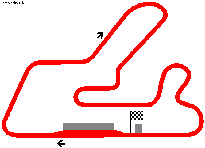
| Autódromo Ciudad de Oberá - Circuito Número 1 | |||||
| Description | |||||
| Years | |||||
| Direction |  Clockwise Clockwise | ||||
 Proposal Proposal |
NO | ||||
| No longer operational | |||||
| Car Circuit | YES | ||||
| Motorbike circuit | |||||
| Type | Permanent | ||||
| Inauguration | November 1st 1992 | ||||
| Closing | |||||
| Last update of this page | November 1st 2007 | ||||
| Info last update | |||||
| Designer | |||||
| Distinctive points | |||||
| length | 2706 m | 8878 ft | 1.681 mi | (7) | |
| length | 2726 m | 8944 ft | 1.694 mi | (6) | |
| length | 2726 m | 8944 ft | 1.694 mi | (3) | |
| length | 2726 m | 8944 ft | 1.694 mi | (2) | |
| Autódromo Ciudad de Oberá - Circuito Número 2 | |||||
| Description | |||||
| Years | 2007÷... | ||||
| Direction | Clockwise | ||||
| Proposal |
NO | ||||
| No longer operational | |||||
| Car Circuit | |||||
| Motorbike circuit | |||||
| Type | Permanent | ||||
| Inauguration | 2007 | ||||
| Closing | |||||
| Last update of this page | November 1st 2007 | ||||
| Info last update | |||||
| Designer | |||||
| Distinctive points | |||||
| length | 4380 m | 14370 ft | 2.722 mi | (7) | |
Autódromo Ciudad de Oberá - Circuito Número 1
| Updates | |||||||
| Date | Track layout | Years | Description by | Map by | Thanks to | Note | |
| November 5th 2007 | Lorenzo Tommasi | Update | Description without map | ||||
| November 1st 2007 | Guido de Carli | Davide Cavalca | Update | Description without map | |||
| January 15th 2005 | Autódromo Ciudad de Oberá - Circuito Número 1 | Guido de Carli | New | Description with map | |||
| September 15th 2004 | Guido de Carli | New | Description | ||||
| November 20th 2003 | Guido de Carli | New | Description | ||||
| Not all eventual updates issued in last years are already visible in this list | |||||||
Webmaster:
Guido de Carli

(Italiano - English - Español)
HOME PAGE