 Visualizza questa pagina in Italiano
 HOME PAGE
|
Visualizza questa pagina in Italiano
|
HOME PAGE
|
Legend and translations |
| SVK - SLOVAKIA | |||||
| DOLNý HRIČOV | |||||
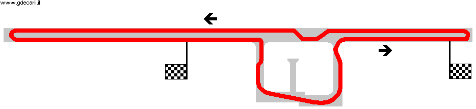
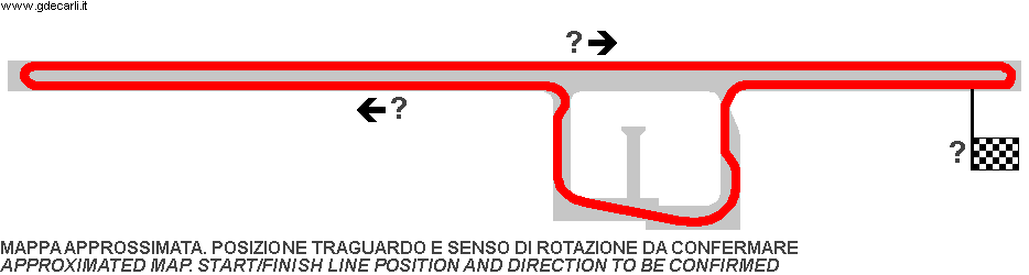
| Description | Circuit used for national motorbikes events with decent international participation. From 1998 to 2000 it hosted motorcycle Slovak Grand Prix, then organizers were nonsensically accused of enriching themselves and also there was a general decline in airport races, so racing stopped there. | ||||
| Location | Dolný Hričov - Žilinský kraj - Stredné Slovensko | ||||
| Location | Žilina Airport, approx. 10 km - 6 mi West of Žilina. Up to 1992 it was in Czechoslovakia | ||||
| Latitude - Longitude | + 49°14'01" + 18°36'50" 49.233611 18.613889 | ||||
| UTM Coordinates | X = 326298.85 - Y = 5456165.861 - Zone 34U | ||||
| Aerial photo / Map (*) |  Google Maps - Bing Maps - Flash Earth - Mapy.cz - Mapy.sk Google Maps - Bing Maps - Flash Earth - Mapy.cz - Mapy.sk | ||||
| Altitude AMSL | 307 m - 1007 ft | ||||
| Inauguration | 1979 | ||||
| Closing | 2000 | ||||
| Designer | |||||
| Sources and links (Translation) (**) |
| ||||
| Dolný Hričov | |||||
| Description | Several layouts were used. I don’t know when two ones shown here had been used | ||||
| Years | 1979÷2000 | ||||
| Direction | |||||
 Proposal Proposal |
NO | ||||
| No longer operational | YES | ||||
| Car Circuit | |||||
| Motorbike circuit | YES | ||||
| Type | Airfield course | ||||
| Inauguration | 1979 | ||||
| Closing | 2000 | ||||
| Last update of this page | May 4th 2008 | ||||
| Info last update | |||||
| Designer | |||||
| Distinctive points | |||||
| length (approx) | 2200 m | 7218 ft | 1.367 mi | Approximated length: minimum value | (1) |
| length (approx) | 2400 m | 7874 ft | 1.491 mi | Approximated length: maximum value | (1) |
Dolný Hričov
| Updates | |||||||
| Date | Track layout | Years | Description by | Map by | Thanks to | Note | |
| May 4th 2008 | 1979÷2000 | Guido de Carli | Guido de Carli | David Griac (jpm) | New | Description with map | |
| Not all eventual updates issued in last years are already visible in this list | |||||||
Webmaster:
Guido de Carli

(Italiano - English - Español)
HOME PAGE