 Visualizza questa pagina in Italiano
 HOME PAGE
|
Visualizza questa pagina in Italiano
|
HOME PAGE
|
Legend and translations |
| AUS - AUSTRALIA | |||||||||||||||||
| BUNBURY | |||||||||||||||||
| Not to be confused with | Bunbury International Circuit | ||||||||||||||||
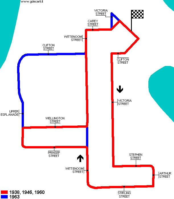
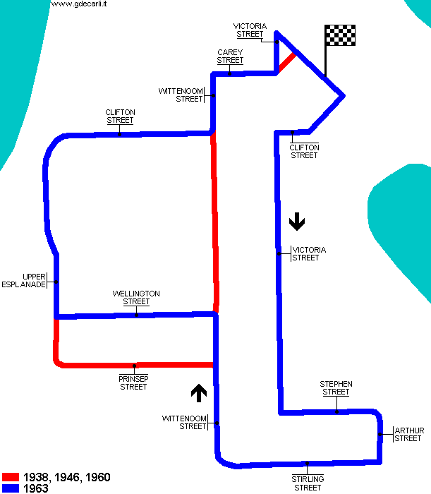
| Description | First layout was first used in 1938 for "Bunbury Flying 50" and then it was used only in 1946 and 1960. In 1962 Carey Park circuit was used, located approx 1km - 0.6 mi South. In 1963 race was back on the original circuit, even if on a different layout. Please note that roads in start/finish area have been completely reprofiled. | ||||||||||||||||
| Location | Bunbury WA - Western Australia | ||||||||||||||||
| Location | |||||||||||||||||
| Latitude - Longitude | - 33°19'21" +115°38'09" -33.3225 115.635833 | ||||||||||||||||
| UTM Coordinates | X = 373026.043 - Y = 6312129.269 - Zone 50H | ||||||||||||||||
| Aerial photo / Map (*) |  Google Maps - Bing Maps - Flash Earth - NearMap Google Maps - Bing Maps - Flash Earth - NearMap | ||||||||||||||||
| Altitude AMSL | 4 m - 13 ft | ||||||||||||||||
| Inauguration | 1938 | ||||||||||||||||
| Closing | 1963 | ||||||||||||||||
| Designer | |||||||||||||||||
| Sources and links (Translation) (**) |
| ||||||||||||||||
| 1938, 1946, 1960 | |||||
| Description | |||||
| Years | |||||
| Direction |  Clockwise Clockwise | ||||
 Proposal Proposal |
NO | ||||
| No longer operational | YES | ||||
| Car Circuit | YES | ||||
| Motorbike circuit | |||||
| Type | Street course | ||||
| Inauguration | 1938 | ||||
| Closing | 1960 | ||||
| Last update of this page | January 3rd 2008 | ||||
| Info last update | |||||
| Designer | |||||
| Distinctive points | Clifton Street - Victoria Street - Stephen Street - Arthur Street - Stirling Street - Wittenoom Street - Prinsep Street - Upper Esplanade - Wellington Street - Wittenoom Street - Carey Street | ||||
| length | 3219 m | 10560 ft | 2 mi | (4) | |
| length | 3219 m | 10560 ft | 2 mi | (3) | |
| length | 3114 m | 10217 ft | 1.935 mi | Calculated from aerial photo (*) | (1) |
| 1963 | |||||
| Description | |||||
| Years | |||||
| Direction | Clockwise | ||||
| Proposal |
NO | ||||
| No longer operational | YES | ||||
| Car Circuit | YES | ||||
| Motorbike circuit | |||||
| Type | Street course | ||||
| Inauguration | 1963 | ||||
| Closing | 1963 | ||||
| Last update of this page | January 3rd 2008 | ||||
| Info last update | |||||
| Designer | |||||
| Distinctive points | Clifton Street - Victoria Street - Stephen Street - Arthur Street - Stirling Street - Wittenoom Street - Wellington Street - Upper Esplanade (Russell Street) - Clifton Street - Wittenoom Street - Carey Street - Victoria Street | ||||
| length | 3220 m | 10563 ft | 2.001 mi | Calculated from aerial photo (*) | (2) |
Bunbury (all layouts)
Due to technical problems, temporarily it’s no longer possible to see the circuits on Google Maps embedded in the current page.
This feature will be restored as soon as I figure out how to do (any help would be appreciated!)
See this track layout with Google Maps - Google Earth
(milermeter.com can be used in your browser, without installing anything; Google Earth is a program that must be installed in your computer)
(Map shown here above can show at the same time all eventual layouts drawn. If you want to see only some of them, please go to Google Maps or Google Earth, by clicking on its own link)
Bunbury 1938, 1946, 1960
Due to technical problems, temporarily it’s no longer possible to see the circuits on Google Maps embedded in the current page.
This feature will be restored as soon as I figure out how to do (any help would be appreciated!)
See this track layout with Google Maps - Google Earth
- milermeter.com
(milermeter.com can be used in your browser, without installing anything; Google Earth is a program that must be installed in your computer)
(Map shown here above can show at the same time all eventual layouts drawn. If you want to see only some of them, please go to Google Maps or Google Earth, by clicking on its own link)
Bunbury 1963
Due to technical problems, temporarily it’s no longer possible to see the circuits on Google Maps embedded in the current page.
This feature will be restored as soon as I figure out how to do (any help would be appreciated!)
See this track layout with Google Maps - Google Earth
- milermeter.com
(milermeter.com can be used in your browser, without installing anything; Google Earth is a program that must be installed in your computer)
(Map shown here above can show at the same time all eventual layouts drawn. If you want to see only some of them, please go to Google Maps or Google Earth, by clicking on its own link)
| Updates | |||||||
| Date | Track layout | Years | Description by | Map by | Thanks to | Note | |
| January 3rd 2008 | Guido de Carli | Guido de Carli | Michel Marti | New | Description with map | ||
| Not all eventual updates issued in last years are already visible in this list | |||||||
Webmaster:
Guido de Carli

(Italiano - English - Español)
HOME PAGE