 Visualizza questa pagina in Italiano
 HOME PAGE
|
Visualizza questa pagina in Italiano
|
HOME PAGE
|
Legend and translations |
| USA - UNITED STATES | |||||||||||||
| SAVANNAH (1908÷1911) | |||||||||||||
| Not to be confused with | Savannah Harbor | ||||||||||||
| Description | |||||||||||||
| Location | Savannah GA - Georgia - Southern States | ||||||||||||
| Location | |||||||||||||
| Latitude - Longitude (approx) | + 32°05'00" - 81°06'00" (approx) 32.083333 -81.1 (approx) | ||||||||||||
| UTM Coordinates (approx) | X = 490563.016 - Y = 3549676.963 - Zone 17S (approx) | ||||||||||||
| Aerial photo / Map (*) |  Google Maps - Bing Maps - Flash Earth - Microsoft Research Maps - MapQuest Google Maps - Bing Maps - Flash Earth - Microsoft Research Maps - MapQuest | ||||||||||||
| Altitude AMSL (approx) | 2 m - 7 ft (approx) | ||||||||||||
| Inauguration | March 1908 | ||||||||||||
| Closing | 1910 | ||||||||||||
| Designer | |||||||||||||
| Sources and links (Translation) (**) |
| ||||||||||||
| Savannah (1908÷1911) | |||||
| Description | |||||
| Years | 1908 | ||||
| Direction |  Anticlockwise Anticlockwise | ||||
 Proposal Proposal |
NO | ||||
| No longer operational | YES | ||||
| Car Circuit | |||||
| Motorbike circuit | |||||
| Type | Road course | ||||
| Inauguration | March 1908 | ||||
| Closing | November 26th 1908 | ||||
| Last update of this page | July 22nd 2007 | ||||
| Info last update | |||||
| Designer | |||||
| Distinctive points | |||||
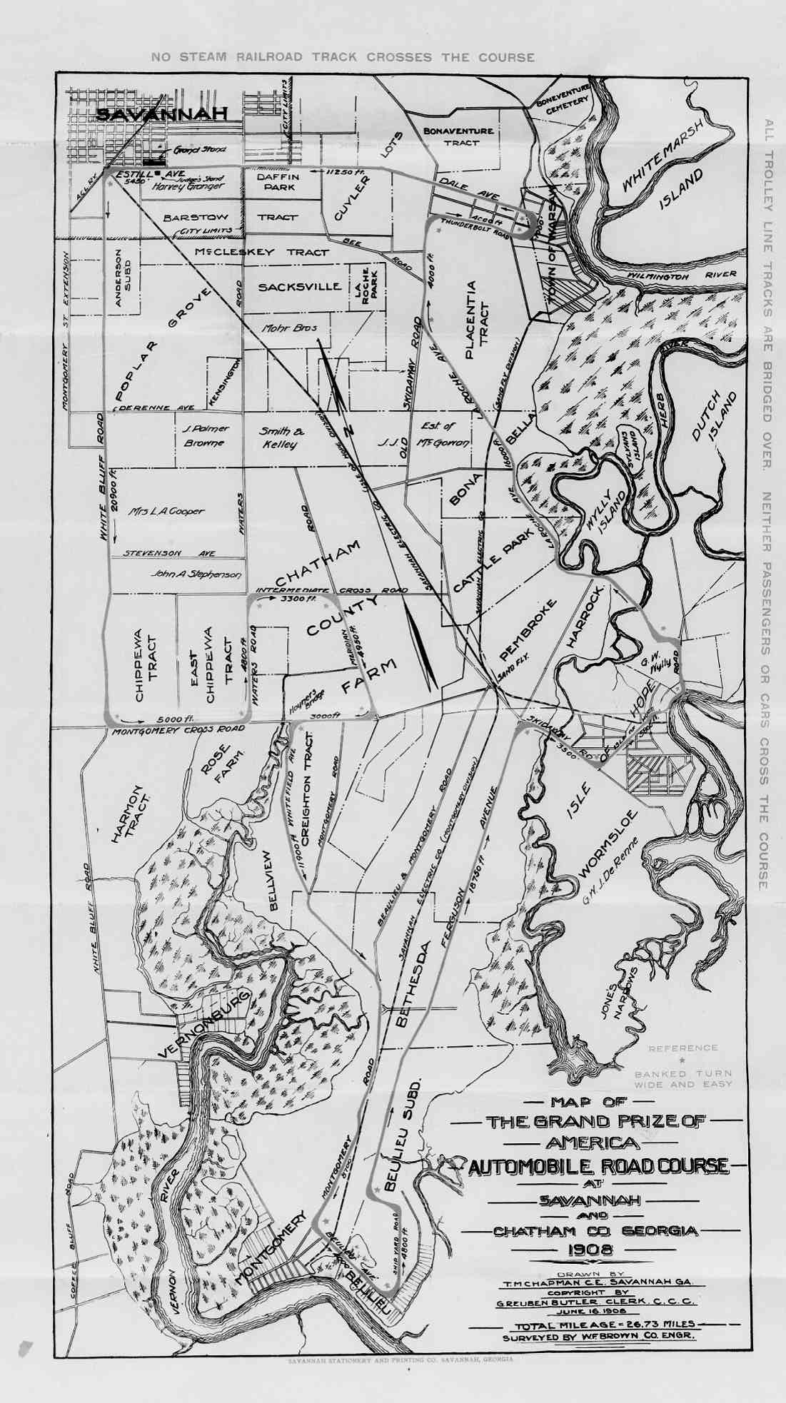
| length | 40.442 km | 25.13 mi | (3) | ||
| Savannah (1908÷1911) | |||||
| Description | |||||
| Years | 1910 | ||||
| Direction | Anticlockwise | ||||
| Proposal |
NO | ||||
| No longer operational | YES | ||||
| Car Circuit | |||||
| Motorbike circuit | |||||
| Type | Road course | ||||
| Inauguration | 1910 | ||||
| Closing | 1910 | ||||
| Last update of this page | July 22nd 2007 | ||||
| Info last update | |||||
| Designer | |||||
| Distinctive points | |||||
| length | 27841 m | 91342 ft | 17.3 mi | (3) | |
| Updates | |||||||
| Date | Track layout | Years | Description by | Map by | Thanks to | Note | |
| July 22nd 2007 | Lorenzo Tommasi | Update | Description | ||||
| Not all eventual updates issued in last years are already visible in this list | |||||||
Webmaster:
Guido de Carli

(Italiano - English - Español)
HOME PAGE
