 Visualizza questa pagina in Italiano
 HOME PAGE
|
Visualizza questa pagina in Italiano
|
HOME PAGE
|
Legend and translations |
| FRA - FRANCE | |||||
| MéRIGNAC | |||||
| SORRY, SOME DATA ARE NOT TRANSLATED YET | |||||
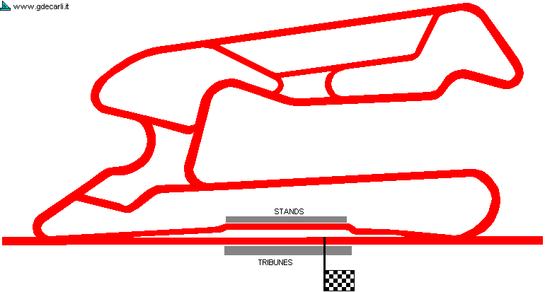
| Description | Permanent circuit suitable up to Formula 2 proposed at the end of 1981. It should have been a circuit without any difference in level and with wide run off areas. Main straight should have been 500 m long, but it could have been lengthened up to 700 m for dragster events. The only problem for its realization come from a law that prevent the constructon of a new circuit if there is another one less the 200 km far: in this case, Nogaro is closer. I have no more info. | ||||
| Location | Mérignac 33 - Gironde - Aquitaine | ||||
| Location | |||||
| Latitude - Longitude (approx) | + 44°50'33" - 0°38'42" (approx) 44.8425 -0.645 (approx) | ||||
| UTM Coordinates (approx) | X = 686118.189 - Y = 4968152.367 - Zone 30T (approx) | ||||
| Aerial photo / Map (*) |  Google Maps - Bing Maps - Flash Earth - GéoPortail Google Maps - Bing Maps - Flash Earth - GéoPortail | ||||
| Altitude AMSL (approx) | 30 m - 98 ft (approx) | ||||
| Inauguration | |||||
| Closing | |||||
| Designer | |||||
| Sources and links (Translation) (**) |
| ||||
| Mérignac | |||||
| Description | |||||
| Years | 1981 | ||||
| Direction | |||||
 Proposal Proposal |
YES
| ||||
| Proposal not developed | YES | ||||
| Car Circuit | YES | ||||
| Motorbike circuit | |||||
| Type | Permanent | ||||
| Inauguration | |||||
| Closing | |||||
| Last update of this page | May 8th 2005 | ||||
| Info last update | December 1981 | ||||
| Designer | |||||
| Distinctive points | |||||
| length | 2500 m | 8202 ft | 1.553 mi | (1) | |
| Straight length | 500 m | 1640 ft | 0.311 mi | (1) | |
| Mérignac | |||||
| Description | |||||
| Years | 1981 | ||||
| Direction | |||||
| Proposal |
YES
| ||||
| Proposal not developed | YES | ||||
| Car Circuit | YES | ||||
| Motorbike circuit | |||||
| Type | Asphalted Drag strip | ||||
| Inauguration | |||||
| Closing | |||||
| Last update of this page | March 4th 2007 | ||||
| Info last update | December 1981 | ||||
| Designer | |||||
| Distinctive points | |||||
| length | 700 m | 2297 ft | 0.435 mi | (1) | |
Mérignac
| Updates | |||||||
| Date | Track layout | Years | Description by | Map by | Thanks to | Note | |
| March 4th 2007 | 1981 | Guido de Carli | |||||
| May 8th 2005 | Guido de Carli | Guido de Carli | New | Description with map | |||
| Not all eventual updates issued in last years are already visible in this list | |||||||
Webmaster:
Guido de Carli

(Italiano - English - Español)
HOME PAGE