 Visualizza questa pagina in Italiano
 HOME PAGE
|
Visualizza questa pagina in Italiano
|
HOME PAGE
|
Legend and translations |
| USA - UNITED STATES | |||||
| BERWICK | |||||
| Description | In its last period it was used as a test track; now it’s used as ordinary road | ||||
| Location | Berwick PA - Pennsylvania - Northeastern States | ||||
| Location | |||||
| Latitude - Longitude | + 41°02'27" - 76°16'06" 41.040833 -76.268333 | ||||
| UTM Coordinates | X = 393395.892 - Y = 4544064.732 - Zone 18T | ||||
| Aerial photo / Map (*) |  Google Maps - Bing Maps - Flash Earth - Microsoft Research Maps - MapQuest Google Maps - Bing Maps - Flash Earth - Microsoft Research Maps - MapQuest | ||||
| Altitude AMSL | |||||
| Inauguration | 1958 | ||||
| Closing | 1958 | ||||
| Designer | |||||
| Sources and links (Translation) (**) |
| ||||
| Berwick | |||||
| Description | |||||
| Years | 1958 | ||||
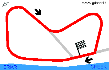
| Direction |  Clockwise Clockwise | ||||
 Proposal Proposal |
NO | ||||
| No longer operational | YES | ||||
| Car Circuit | |||||
| Motorbike circuit | |||||
| Type | Road course | ||||
| Inauguration | 1958 | ||||
| Closing | 1958 | ||||
| Last update of this page | February 8th 2007 | ||||
| Info last update | |||||
| Designer | |||||
| Distinctive points | |||||
| length | 1609 m | 5280 ft | 1 mi | (1) | |
Berwick
| Updates | |||||||
| Date | Track layout | Years | Description by | Map by | Thanks to | Note | |
| February 8th 2007 | 1958 | Guido de Carli | |||||
| Not all eventual updates issued in last years are already visible in this list | |||||||
Webmaster:
Guido de Carli

(Italiano - English - Español)
HOME PAGE