 Visualizza questa pagina in Italiano
 HOME PAGE
|
Visualizza questa pagina in Italiano
|
HOME PAGE
|
Legend and translations |
| SVK - SLOVAKIA | |||||||||||||||||||||
| PIEŠŤANY | |||||||||||||||||||||
| Not to be confused with | Piešťany (1949÷1955) - Piestany (1956) | ||||||||||||||||||||
| Description | Circuit still in use (2007), in 2008 it will host a Slovakian Touring Car Championship event | ||||||||||||||||||||
| Location | Piešťany - Trnavský kraj - Západné Slovensko | ||||||||||||||||||||
| Location | Piešťany Northern suburb | ||||||||||||||||||||
| Latitude - Longitude | + 48°37'30" + 17°49'47" 48.625 17.829722 | ||||||||||||||||||||
| UTM Coordinates | X = 708511.73 - Y = 5389635.449 - Zone 33U | ||||||||||||||||||||
| Aerial photo / Map (*) |  Google Maps - Bing Maps - Flash Earth - Mapy.cz - Mapy.sk Google Maps - Bing Maps - Flash Earth - Mapy.cz - Mapy.sk | ||||||||||||||||||||
| Altitude AMSL | 160 m - 525 ft | ||||||||||||||||||||
| Inauguration | |||||||||||||||||||||
| Closing | |||||||||||||||||||||
| Designer | |||||||||||||||||||||
| Sources and links (Translation) (**) |
| ||||||||||||||||||||
| Piešťany | |||||
| Description | |||||
| Years | |||||
| Direction |  Clockwise Clockwise | ||||
 Proposal Proposal |
NO | ||||
| No longer operational | |||||
| Car Circuit | YES | ||||
| Motorbike circuit | |||||
| Type | Airfield course | ||||
| Inauguration | |||||
| Closing | |||||
| Last update of this page | November 13th 2007 | ||||
| Info last update | |||||
| Designer | |||||
| Distinctive points | |||||
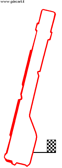
| length | 4400 m | 14436 ft | 2.734 mi | (5) | |
| length | 4450 m | 14599 ft | 2.765 mi | Calculated from aerial photo (*) | (4) |
Piešťany
Due to technical problems, temporarily it’s no longer possible to see the circuits on Google Maps embedded in the current page.
This feature will be restored as soon as I figure out how to do (any help would be appreciated!)
See this track layout with Google Maps - Google Earth
- milermeter.com
(milermeter.com can be used in your browser, without installing anything; Google Earth is a program that must be installed in your computer)
(Map shown here above can show at the same time all eventual layouts drawn. If you want to see only some of them, please go to Google Maps or Google Earth, by clicking on its own link)
| Updates | |||||||
| Date | Track layout | Years | Description by | Map by | Thanks to | Note | |
| December 1st 2007 | Guido de Carli | Guido de Carli | Update | Map | |||
| November 15th 2007 | Guido de Carli | Martin Berrang | Update | Description | |||
| November 13th 2007 | Lorenzo Tommasi | Guido de Carli | Update | Map | |||
| November 8th 2007 | Lorenzo Tommasi | Update | Description | ||||
| February 3rd 2007 | Guido de Carli | ||||||
| Not all eventual updates issued in last years are already visible in this list | |||||||
Webmaster:
Guido de Carli

(Italiano - English - Español)
HOME PAGE