 Visualizza questa pagina in Italiano
 HOME PAGE
|
Visualizza questa pagina in Italiano
|
HOME PAGE
|
Legend and translations |
| ESP - SPAIN | |||||||||||||
| LA MUELA | |||||||||||||
| SORRY, SOME DATA ARE NOT TRANSLATED YET | |||||||||||||
| Description | |||||||||||||
| Location | La Muela Z - Zaragoza - Aragón | ||||||||||||
| Location | |||||||||||||
| Latitude - Longitude (approx) | + 41°34'51" - 1°07'09" (approx) 41.580833 -1.119167 (approx) | ||||||||||||
| UTM Coordinates (approx) | X = 656787.584 - Y = 4604946.536 - Zone 30T (approx) | ||||||||||||
| Aerial photo / Map (*) |  Google Maps - Bing Maps - Flash Earth - Visor SIGPAC Google Maps - Bing Maps - Flash Earth - Visor SIGPAC | ||||||||||||
| Altitude AMSL (approx) | 600 m - 1969 ft (approx) | ||||||||||||
| Inauguration | |||||||||||||
| Closing | |||||||||||||
| Designer | |||||||||||||
| Sources and links (Translation) (**) |
| ||||||||||||
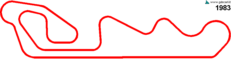
| La Muela | |||||
| Description | |||||
| Years | 1983 | ||||
| Direction | |||||
 Proposal Proposal |
YES
| ||||
| Proposal not developed | YES | ||||
| Car Circuit | YES | ||||
| Motorbike circuit | |||||
| Type | Permanent | ||||
| Inauguration | |||||
| Closing | |||||
| Last update of this page | January 5th 2006 | ||||
| Info last update | 1983 | ||||
| Designer | |||||
| Distinctive points | |||||
| length | 5322 m | 17461 ft | 3.307 mi | (1) | |
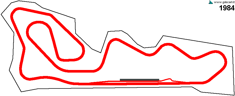
| La Muela | |||||
| Description | |||||
| Years | 1984 | ||||
| Direction | |||||
| Proposal |
YES
| ||||
| Proposal not developed | YES | ||||
| Car Circuit | YES | ||||
| Motorbike circuit | |||||
| Type | Permanent | ||||
| Inauguration | |||||
| Closing | |||||
| Last update of this page | August 15th 2005 | ||||
| Info last update | June 1984 | ||||
| Designer | |||||
| Distinctive points | |||||
| length | 5300 m | 17388 ft | 3.293 mi | (3) | |
| length | 5330 m | 17487 ft | 3.312 mi | (2) | |
| Width | 12 m | 39 ft | (3) | ||
| Total area | 110 hectares | 1100000 m² | 271.813 acres | (3) | |
La Muela 1983
La Muela 1984
| Updates | |||||||
| Date | Track layout | Years | Description by | Map by | Thanks to | Note | |
| February 23rd 2006 | Guido de Carli | Guido de Carli | New | Description with map | |||
| January 5th 2006 | Guido de Carli | Rafa Reyna | New | Description | |||
| August 17th 2005 | Guido de Carli | Update | Description | ||||
| April 25th 2005 | Guido de Carli | New | Description without map | ||||
| Not all eventual updates issued in last years are already visible in this list | |||||||
Webmaster:
Guido de Carli

(Italiano - English - Español)
HOME PAGE