 Visualizza questa pagina in Italiano
 HOME PAGE
|
Visualizza questa pagina in Italiano
|
HOME PAGE
|
Legend and translations |
| USA - UNITED STATES | |||||||||||||||||||||||||||||||||
| LAS VEGAS, CAESARS PALACE | |||||||||||||||||||||||||||||||||
| SORRY, SOME DATA ARE NOT TRANSLATED YET | |||||||||||||||||||||||||||||||||
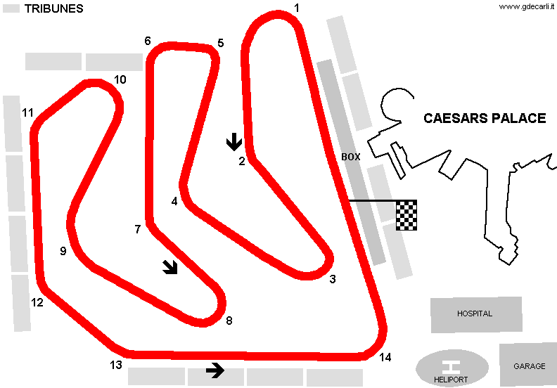
| Description | Street circuit obtained mostly in Caesars Palace Hotel parking. It hosted Las Vegas F.1 GP in 1981 and 1982; they were both the last of the season and both crucial for world championship giving. F.1 race was in 1983 calendar too, bur it was canceled after season started. In 1983-1984 GP was raced by Cart on an oval track (not shown in my map) obtained more or less from external perimeter of F.1 one, but with a different layout in corner 14 area. | ||||||||||||||||||||||||||||||||
| Location | Las Vegas NV - Nevada - Western States | ||||||||||||||||||||||||||||||||
| Location | Nearby Caesars Palace Hotel, Las Vegas | ||||||||||||||||||||||||||||||||
| Latitude - Longitude | + 36°07'29" -115°10'34" 36.124722 -115.176111 | ||||||||||||||||||||||||||||||||
| UTM Coordinates | X = 664132.079 - Y = 3999322.519 - Zone 11S | ||||||||||||||||||||||||||||||||
| Aerial photo / Map (*) |  Google Maps - Bing Maps - Flash Earth - Microsoft Research Maps - MapQuest Google Maps - Bing Maps - Flash Earth - Microsoft Research Maps - MapQuest | ||||||||||||||||||||||||||||||||
| Altitude AMSL | 639 m - 2096 ft | ||||||||||||||||||||||||||||||||
| Inauguration | October 17th 1981 | ||||||||||||||||||||||||||||||||
| Closing | November 11th 1984 | ||||||||||||||||||||||||||||||||
| Designer | |||||||||||||||||||||||||||||||||
| Sources and links (Translation) (**) |
| ||||||||||||||||||||||||||||||||
| Caesars Palace | |||||
| Description | In August 1981, few weeks before Las Vegas F.1, organizers announced that they slightly changed track layout, by canceling a couple of corners. Even before the GP, the track was considered similar to a kart track and it gave raise to complaint because of safety and for having no room for journalists and photographers. | ||||
| Years | 1981 | ||||
| Direction |  Anticlockwise Anticlockwise | ||||
 Proposal Proposal |
YES
| ||||
| Proposal not developed | YES | ||||
| Car Circuit | YES | ||||
| Motorbike circuit | |||||
| Type | Street course | ||||
| Inauguration | |||||
| Closing | |||||
| Last update of this page | January 30th 2005 | ||||
| Info last update | August 1981 | ||||
| Designer | |||||
| Distinctive points | |||||
| Caesars Palace | |||||
| Description | |||||
| Years | 1981÷1982 | ||||
| Direction | Anticlockwise | ||||
| Proposal |
NO | ||||
| No longer operational | YES | ||||
| Car Circuit | YES | ||||
| Motorbike circuit | |||||
| Type | Street course | ||||
| Inauguration | October 17th 1981 | ||||
| Closing | October 25th 1982 | ||||
| Last update of this page | January 30th 2005 | ||||
| Info last update | |||||
| Designer | |||||
| Distinctive points | |||||
| length | 3650 m | 11975 ft | 2.268 mi | (8) | |
| Caesars Palace | |||||
| Description | Street oval circuit, used by CAT (now Champ Car) | ||||
| Years | 1983÷1984 | ||||
| Direction | Anticlockwise | ||||
| Proposal |
NO | ||||
| No longer operational | YES | ||||
| Car Circuit | YES | ||||
| Motorbike circuit | |||||
| Type | Street course | ||||
| Inauguration | October 9th 1983 | ||||
| Closing | November 11th 1984 | ||||
| Last update of this page | January 30th 2005 | ||||
| Info last update | |||||
| Designer | |||||
| Distinctive points | |||||
| length | 2913 m | 9557 ft | 1.81 mi | (1) | |
Las Vegas: Stardust International Raceway, Las Vegas Motor Speedway / Las Vegas Raceway Park, Caesars Palace, progetto 1997, Sam Boyd Stadium, Freemont Street Experience, progetto D3
Due to technical problems, temporarily it’s no longer possible to see the circuits on Google Maps embedded in the current page.
This feature will be restored as soon as I figure out how to do (any help would be appreciated!)
See this track layout with Google Maps - Google Earth
(milermeter.com can be used in your browser, without installing anything; Google Earth is a program that must be installed in your computer)
(Map shown here above can show at the same time all eventual layouts drawn. If you want to see only some of them, please go to Google Maps or Google Earth, by clicking on its own link)
August 1981 proposal
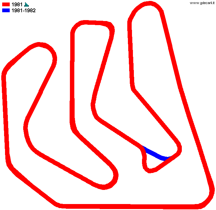
1981÷1982 F.1 track
Due to technical problems, temporarily it’s no longer possible to see the circuits on Google Maps embedded in the current page.
This feature will be restored as soon as I figure out how to do (any help would be appreciated!)
See this track layout with Google Maps - Google Earth
(milermeter.com can be used in your browser, without installing anything; Google Earth is a program that must be installed in your computer)
(Map shown here above can show at the same time all eventual layouts drawn. If you want to see only some of them, please go to Google Maps or Google Earth, by clicking on its own link)
| Updates | |||||||
| Date | Track layout | Years | Description by | Map by | Thanks to | Note | |
| May 19th 2010 | Caesars Palace | 1981÷1982 | Guido de Carli | Roelard Smit | Roelard Smit | Update | Map |
| May 9th 2007 | Lorenzo Tommasi | Update | Description | ||||
| March 25th 2005 | Caesars Palace | 1981 | Guido de Carli | Guido de Carli | New | Description with map | |
| January 30th 2005 | Guido de Carli | New | Description with map | ||||
| Not all eventual updates issued in last years are already visible in this list | |||||||
Webmaster:
Guido de Carli

(Italiano - English - Español)
HOME PAGE