 Visualizza questa pagina in Italiano
 HOME PAGE
|
Visualizza questa pagina in Italiano
|
HOME PAGE
|
Legend and translations |
| CZE - CZECH REPUBLIC | |||||||||||||||||||||||||||||||||||||||||||||
| MOST (AUTODROM) | |||||||||||||||||||||||||||||||||||||||||||||
| Description | In 1976 a permanent street circuit was at first proposed. It should have replaced all street circuits, the last used from 1979 to 1982. In 1982 a new circuit 5.8 km - 3.6 mi long was announced, but I don’t know differences with definitive layout, opened in Summer 1983. In 2005 first bend was modified (not shown on my map) | ||||||||||||||||||||||||||||||||||||||||||||
| Location | Most U - Ústecký kraj - Severozápad | ||||||||||||||||||||||||||||||||||||||||||||
| Location | 80 km North-West from Praha (Prague), not far from border with Germany. Until December 31st 1992 it was in Czechoslovakia | ||||||||||||||||||||||||||||||||||||||||||||
| Latitude - Longitude | + 50°31'11" + 13°36'12" 50.519722 13.603333 | ||||||||||||||||||||||||||||||||||||||||||||
| UTM Coordinates | X = 400990.015 - Y = 5597349.881 - Zone 33U | ||||||||||||||||||||||||||||||||||||||||||||
| Aerial photo / Map (*) |  Google Maps - Bing Maps - Flash Earth - Mapy.cz Google Maps - Bing Maps - Flash Earth - Mapy.cz | ||||||||||||||||||||||||||||||||||||||||||||
| Altitude AMSL | 280 m - 919 ft | ||||||||||||||||||||||||||||||||||||||||||||
| Inauguration | August 14th 1983 | ||||||||||||||||||||||||||||||||||||||||||||
| Closing | |||||||||||||||||||||||||||||||||||||||||||||
| Designer | |||||||||||||||||||||||||||||||||||||||||||||
| Sources and links (Translation) (**) |
| ||||||||||||||||||||||||||||||||||||||||||||
| Most (Autodrom) | |||||
| Description | 1982 layout, I think slightly diferent from the final one | ||||
| Years | 1982 | ||||
| Direction | |||||
 Proposal Proposal |
YES
| ||||
| Proposal not developed | YES | ||||
| Car Circuit | YES | ||||
| Motorbike circuit | |||||
| Type | Permanent | ||||
| Inauguration | |||||
| Closing | |||||
| Last update of this page | March 4th 2007 | ||||
| Info last update | September 1982 | ||||
| Designer | |||||
| Distinctive points | |||||
| Most (Autodrom) | |||||
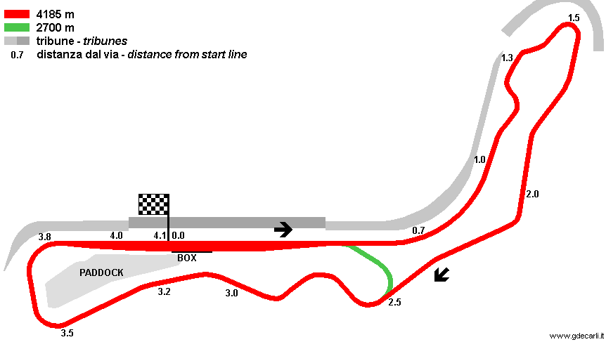
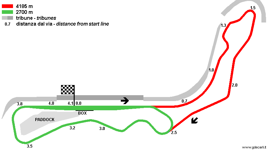
| Description | Boxes have 40 garages. Tribunes can host 250,000 spectators; 70,000 in the covered one (dark grey on the map) | ||||
| Years | 1983÷2004 | ||||
| Direction |  Clockwise Clockwise | ||||
| Proposal |
NO | ||||
| No longer operational | YES | ||||
| Car Circuit | YES | ||||
| Motorbike circuit | YES | ||||
| Type | Permanent | ||||
| Inauguration | August 14th 1983 | ||||
| Closing | 2004 | ||||
| Last update of this page | November 6th 2004 | ||||
| Info last update | |||||
| Designer | |||||
| Distinctive points | |||||
| length | 4148.24 m | 13610 ft | 2.578 mi | Long circuit | (10) |
| length | 4185 m | 13730 ft | 2.601 mi | Long circuit | (8) |
| length | 2324.8 m | 7627 ft | 1.445 mi | Short circuit | (10) |
| length | 2700 m | 8858 ft | 1.678 mi | Short circuit | (8) |
| Min width | 12 m | 39 ft | (8) | ||
| Max width | 15 m | 49 ft | (8) | ||
| Straight length | 900 m | 2953 ft | 0.559 mi | Short circuit | (8) |
| Straight length | 1050 m | 3445 ft | 0.652 mi | Longest straight | (8) |
| Most (Autodrom) | |||||
| Description | |||||
| Years | 2005÷... | ||||
| Direction | Clockwise | ||||
| Proposal |
NO | ||||
| No longer operational | |||||
| Car Circuit | YES | ||||
| Motorbike circuit | YES | ||||
| Type | Permanent | ||||
| Inauguration | 2005 | ||||
| Closing | |||||
| Last update of this page | March 10th 2005 | ||||
| Info last update | |||||
| Designer | |||||
| Distinctive points | |||||
| length | 4222 m | 13852 ft | 2.624 mi | (10) | |
| Min width | 12 m | 39 ft | (10) | ||
| Max width | 14 m | 46 ft | (10) | ||
| Difference in level | 12.04 m | 40 ft | (10) | ||
| Straight length | 792 m | 2598 ft | 0.492 mi | Longest straight | (10) |
| Max. gradient (uphill) | 2.8 m | 9 ft | (10) | ||
| Max. gradient (downhill) | 3.2 m | 10 ft | (10) | ||
1983÷2004, long course
| Updates | |||||||
| Date | Track layout | Years | Description by | Map by | Thanks to | Note | |
| April 8th 2008 | Guido de Carli | Update | Description | ||||
| February 10th 2008 | Guido de Carli | Update | Description | ||||
| March 4th 2007 | 1982 | Guido de Carli | |||||
| August 12th 2005 | 1983÷2004 | Guido de Carli | Update | Description | |||
| March 10th 2005 | 2005÷... | Guido de Carli | New | Description | |||
| December 27th 2003 | Guido de Carli | Guido de Carli | New | Description with map | |||
| Not all eventual updates issued in last years are already visible in this list | |||||||
Webmaster:
Guido de Carli

(Italiano - English - Español)
HOME PAGE