 Visualizza questa pagina in Italiano
 HOME PAGE
|
Visualizza questa pagina in Italiano
|
HOME PAGE
|
Legend and translations |
| CZE - CZECH REPUBLIC | |||||||||||||||||||||||||
| HAVíŘOV | |||||||||||||||||||||||||
| Description | Circuit used - among other events - for Eastern European Peace & Friendship Cup. | ||||||||||||||||||||||||
| Location | Havířov T - Moravskoslezský kraj - Moravskoslezsko | ||||||||||||||||||||||||
| Location | |||||||||||||||||||||||||
| Latitude - Longitude | + 49°47'09" + 18°23'22" 49.785833 18.389444 | ||||||||||||||||||||||||
| UTM Coordinates | X = 312090.049 - Y = 5518089.135 - Zone 34U | ||||||||||||||||||||||||
| Aerial photo / Map (*) |  Google Maps - Bing Maps - Flash Earth - Mapy.cz Google Maps - Bing Maps - Flash Earth - Mapy.cz | ||||||||||||||||||||||||
| Altitude AMSL | 233 m - 764 ft | ||||||||||||||||||||||||
| Inauguration | 1971 | ||||||||||||||||||||||||
| Closing | 1995 | ||||||||||||||||||||||||
| Designer | |||||||||||||||||||||||||
| Sources and links (Translation) (**) |
| ||||||||||||||||||||||||
| Havířov | |||||
| Description | Direction anticlockwise to be confirmed | ||||
| Years | 1971÷1974 | ||||
| Direction |  Anticlockwise Anticlockwise | ||||
 Proposal Proposal |
NO | ||||
| No longer operational | YES | ||||
| Car Circuit | YES | ||||
| Motorbike circuit | |||||
| Type | Street course | ||||
| Inauguration | 1971 | ||||
| Closing | 1974 | ||||
| Last update of this page | April 18th 2008 | ||||
| Info last update | |||||
| Designer | |||||
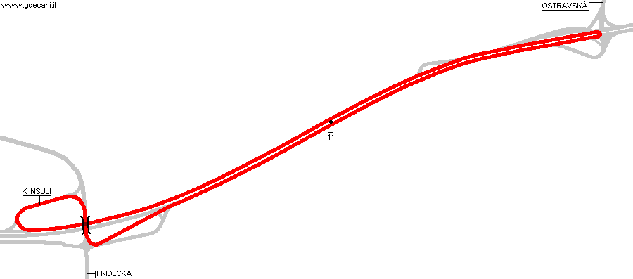
| Distinctive points | 11 - K Insuli - Fridecka - Ostravská | ||||
| length | 4085 m | 13401 ft | 2.538 mi | Calculated from aerial photo (*) | (3) |
| Havířov | |||||
| Description | Direction anticlockwise to be confirmed | ||||
| Years | 1975÷1980 | ||||
| Direction | Anticlockwise | ||||
| Proposal |
NO | ||||
| No longer operational | YES | ||||
| Car Circuit | YES | ||||
| Motorbike circuit | |||||
| Type | Street course | ||||
| Inauguration | 1975 | ||||
| Closing | 1980 | ||||
| Last update of this page | April 18th 2008 | ||||
| Info last update | |||||
| Designer | |||||
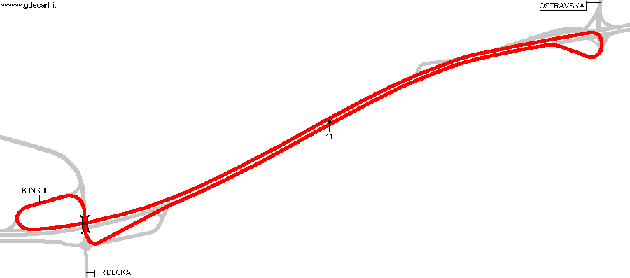
| Distinctive points | 11 - K Insuli - Fridecka - Ostravská | ||||
| length | 4100 m | 13451 ft | 2.548 mi | (5) | |
| length | 4140 m | 13584 ft | 2.573 mi | Calculated from aerial photo (*) | (2) |
| Havířov | |||||
| Description | Direction anticlockwise to be confirmed | ||||
| Years | 1981÷1995 | ||||
| Direction | Anticlockwise | ||||
| Proposal |
NO | ||||
| No longer operational | YES | ||||
| Car Circuit | YES | ||||
| Motorbike circuit | |||||
| Type | Street course | ||||
| Inauguration | 1981 | ||||
| Closing | 1995 | ||||
| Last update of this page | April 18th 2008 | ||||
| Info last update | |||||
| Designer | |||||
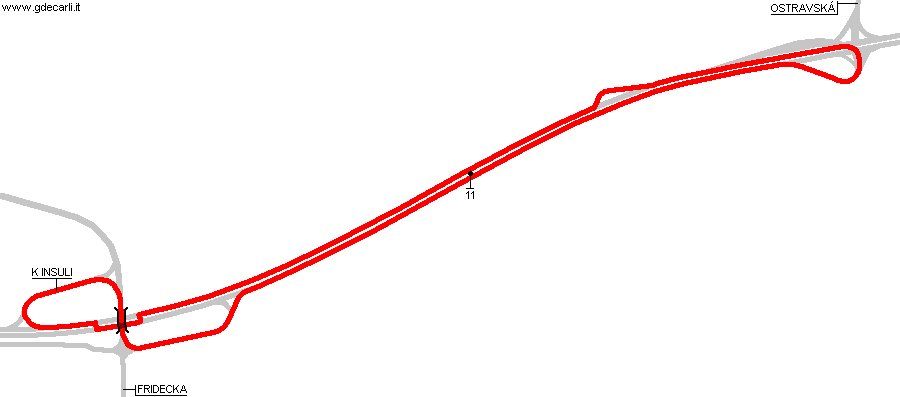
| Distinctive points | 11 - K Insuli - Fridecka - Ostravská | ||||
| length | 4207 m | 13802 ft | 2.614 mi | Calculated from aerial photo (*) | (4) |
Havířov 1971÷1974
Due to technical problems, temporarily it’s no longer possible to see the circuits on Google Maps embedded in the current page.
This feature will be restored as soon as I figure out how to do (any help would be appreciated!)
See this track layout with Google Maps - Google Earth
- milermeter.com
(milermeter.com can be used in your browser, without installing anything; Google Earth is a program that must be installed in your computer)
(Map shown here above can show at the same time all eventual layouts drawn. If you want to see only some of them, please go to Google Maps or Google Earth, by clicking on its own link)
Havířov 1975÷1980
Due to technical problems, temporarily it’s no longer possible to see the circuits on Google Maps embedded in the current page.
This feature will be restored as soon as I figure out how to do (any help would be appreciated!)
See this track layout with Google Maps - Google Earth
- milermeter.com
(milermeter.com can be used in your browser, without installing anything; Google Earth is a program that must be installed in your computer)
(Map shown here above can show at the same time all eventual layouts drawn. If you want to see only some of them, please go to Google Maps or Google Earth, by clicking on its own link)
Havířov 1981÷1995
Due to technical problems, temporarily it’s no longer possible to see the circuits on Google Maps embedded in the current page.
This feature will be restored as soon as I figure out how to do (any help would be appreciated!)
See this track layout with Google Maps - Google Earth
- milermeter.com
(milermeter.com can be used in your browser, without installing anything; Google Earth is a program that must be installed in your computer)
(Map shown here above can show at the same time all eventual layouts drawn. If you want to see only some of them, please go to Google Maps or Google Earth, by clicking on its own link)
| Updates | |||||||
| Date | Track layout | Years | Description by | Map by | Thanks to | Note | |
| April 18th 2008 | Guido de Carli | Guido de Carli | David Griac (jpm) | Update | Map | ||
| November 25th 2007 | 1975÷1980 | Guido de Carli | Guido de Carli | New | Map | ||
| March 17th 2006 | Guido de Carli | Roelard Smit | New | Description | |||
| Not all eventual updates issued in last years are already visible in this list | |||||||
Webmaster:
Guido de Carli

(Italiano - English - Español)
HOME PAGE