 Visualizza questa pagina in Italiano
 HOME PAGE
|
Visualizza questa pagina in Italiano
|
HOME PAGE
|
Legend and translations |
| ITA - ITALY | |||||||||||||||||
| CASERTA | |||||||||||||||||
| SORRY, SOME DATA ARE NOT TRANSLATED YET | |||||||||||||||||
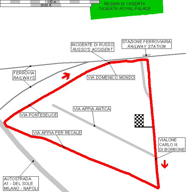
| Description | Street circuit used with diferent layouts from 1928 to 1967, when in a race valid for Italian F.3 championship in a big accident died "Geki" Russo. The accident took place around the gentle right hand curve (see the map) | ||||||||||||||||
| Location | Caserta CE - Caserta - Campania | ||||||||||||||||
| Location | Few hundreds South of Caserta Royal Palace | ||||||||||||||||
| Latitude - Longitude | + 41°03'50" + 14°19'19" 41.063889 14.321944 | ||||||||||||||||
| UTM Coordinates | X = 443029.367 - Y = 4546070.836 - Zone 33T | ||||||||||||||||
| Aerial photo / Map (*) |  Google Maps - Bing Maps - Flash Earth - Portale Cartografico Nazionale - Visual Pagine Gialle Google Maps - Bing Maps - Flash Earth - Portale Cartografico Nazionale - Visual Pagine Gialle | ||||||||||||||||
| Altitude AMSL | 56 m - 184 ft | ||||||||||||||||
| Inauguration | |||||||||||||||||
| Closing | |||||||||||||||||
| Designer | |||||||||||||||||
| Sources and links (Translation) (**) |
| ||||||||||||||||
| Caserta | |||||
| Description | |||||
| Years | 1928÷1929 | ||||
| Direction | |||||
 Proposal Proposal |
NO | ||||
| No longer operational | YES | ||||
| Car Circuit | |||||
| Motorbike circuit | |||||
| Type | |||||
| Inauguration | |||||
| Closing | |||||
| Last update of this page | April 4th 2006 | ||||
| Info last update | |||||
| Designer | |||||
| Distinctive points | |||||
| length | 21500 m | 70538 ft | 13.36 mi | ||
| Caserta | |||||
| Description | |||||
| Years | 1930 | ||||
| Direction | |||||
| Proposal |
NO | ||||
| No longer operational | YES | ||||
| Car Circuit | |||||
| Motorbike circuit | |||||
| Type | |||||
| Inauguration | |||||
| Closing | |||||
| Last update of this page | April 4th 2006 | ||||
| Info last update | |||||
| Designer | |||||
| Distinctive points | |||||
| length | 25370 m | 83235 ft | 15.765 mi | ||
| Caserta | |||||
| Description | |||||
| Years | 1951÷1952 | ||||
| Direction |  Clockwise Clockwise | ||||
| Proposal |
NO | ||||
| No longer operational | YES | ||||
| Car Circuit | YES | ||||
| Motorbike circuit | |||||
| Type | Street course | ||||
| Inauguration | |||||
| Closing | |||||
| Last update of this page | April 4th 2006 | ||||
| Info last update | |||||
| Designer | |||||
| Distinctive points | |||||
| length | 4600 m | 15092 ft | 2.858 mi | ||
| Caserta | |||||
| Description | Layout confirmed as shown on my map (previously I had some doubts) | ||||
| Years | 1953÷1967 | ||||
| Direction | Clockwise | ||||
| Proposal |
NO | ||||
| No longer operational | YES | ||||
| Car Circuit | YES | ||||
| Motorbike circuit | |||||
| Type | Street course | ||||
| Inauguration | |||||
| Closing | |||||
| Last update of this page | May 18th 2008 | ||||
| Info last update | |||||
| Designer | |||||
| Distinctive points | |||||
| length | 4550 m | 14928 ft | 2.827 mi | ||
| Straight length | 1269 m | 4163 ft | 0.789 mi | Start finish straight | (3) |
| Straight length | 1620 m | 5315 ft | 1.007 mi | Straight between turn 2 and turn 3 | (3) |
| Straight length | 1708 m | 5604 ft | 1.061 mi | Straight between turn 1 and turn 2 | (3) |
Caserta 1953÷1967
| Updates | |||||||
| Date | Track layout | Years | Description by | Map by | Thanks to | Note | |
| May 18th 2008 | 1953÷1967 | Guido de Carli | Update | Description | |||
| August 18th 2005 | Guido de Carli | Update | Description | ||||
| May 13th 2004 | Guido de Carli | Update | Description | ||||
| July 5th 2003 | Guido de Carli | Guido de Carli | New | Description with map | |||
| July 2nd 2003 | Guido de Carli | New | Description | ||||
| Not all eventual updates issued in last years are already visible in this list | |||||||
Webmaster:
Guido de Carli

(Italiano - English - Español)
HOME PAGE