 Visualizza questa pagina in Italiano
 HOME PAGE
|
Visualizza questa pagina in Italiano
|
HOME PAGE
|
Legend and translations |
| ITA - ITALY | |||||||||
| MILANO MARITTIMA | |||||||||
| Description | Track used for Circuito Motociclistico di Cervia Milano Marittima (Motorbike Circuit of Cervia Milano Marittima) up to 1970, then it was abandoned because of safety reason: safety "devices" were only hay balls, as usual in that period. | ||||||||
| Location | Milano Marittima, Cervia RA - Ravenna - Emilia Romagna | ||||||||
| Location | |||||||||
| Latitude - Longitude | + 44°17'08" + 12°20'51" 44.285556 12.3475 | ||||||||
| UTM Coordinates | X = 288358.791 - Y = 4907011.575 - Zone 33T | ||||||||
| Aerial photo / Map (*) |  Google Maps - Bing Maps - Flash Earth - Portale Cartografico Nazionale - Visual Pagine Gialle Google Maps - Bing Maps - Flash Earth - Portale Cartografico Nazionale - Visual Pagine Gialle | ||||||||
| Altitude AMSL | 1 m - 3 ft | ||||||||
| Inauguration | April 12th 1964 | ||||||||
| Closing | 1970 | ||||||||
| Designer | |||||||||
| Sources and links (Translation) (**) |
| ||||||||
| Milano Marittima | |||||
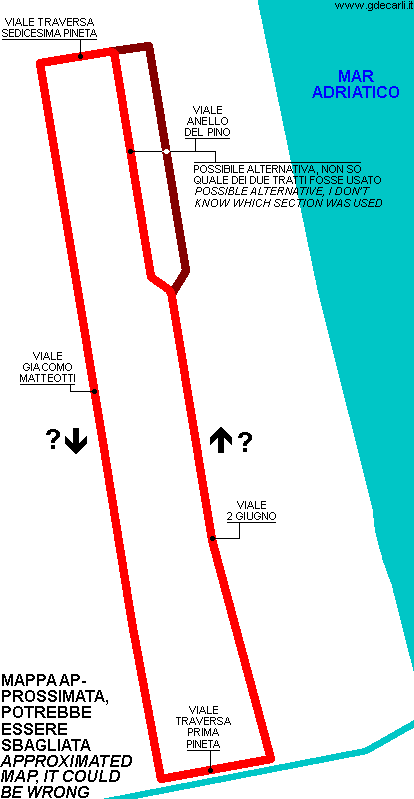
| Description | Map is approximated and taken from a description. Direction anticlocwise seems me likely looking at photos showing motorbikes turning left. The track went on Viale Anello del Pino, but I don’t know which section was used. Track length calculated on aerial photo is referred to the red layout shown on my map | ||||
| Years | 1964÷1970 | ||||
| Direction |  Anticlockwise Anticlockwise | ||||
 Proposal Proposal |
NO | ||||
| No longer operational | YES | ||||
| Car Circuit | |||||
| Motorbike circuit | YES | ||||
| Type | Street course | ||||
| Inauguration | April 12th 1964 | ||||
| Closing | 1970 | ||||
| Last update of this page | December 1st 2007 | ||||
| Info last update | |||||
| Designer | |||||
| Distinctive points | Viale Giacomo Matteotti - Viale Traversa Prima Pineta - Viale 2 Giugno - Viale Anello del Pino - Viale Traversa Sedicesima Pineta | ||||
| length | 3400 m | 11155 ft | 2.113 mi | (1) | |
| length | 2924.6 m | 9595 ft | 1.817 mi | Calculated from aerial photo (*) | (2) |
Milano Marittima
Due to technical problems, temporarily it’s no longer possible to see the circuits on Google Maps embedded in the current page.
This feature will be restored as soon as I figure out how to do (any help would be appreciated!)
See this track layout with Google Maps - Google Earth
- milermeter.com
(milermeter.com can be used in your browser, without installing anything; Google Earth is a program that must be installed in your computer)
(Map shown here above can show at the same time all eventual layouts drawn. If you want to see only some of them, please go to Google Maps or Google Earth, by clicking on its own link)
| Updates | |||||||
| Date | Track layout | Years | Description by | Map by | Thanks to | Note | |
| December 1st 2007 | Guido de Carli | Guido de Carli | Nanni Dietrich | Update | Description with map | ||
| Not all eventual updates issued in last years are already visible in this list | |||||||
Webmaster:
Guido de Carli

(Italiano - English - Español)
HOME PAGE