 Visualizza questa pagina in Italiano
 HOME PAGE
|
Visualizza questa pagina in Italiano
|
HOME PAGE
|
Legend and translations |
| ITA - ITALY | |||||||||||||||||
| VENEZIA, SAN MARCO | |||||||||||||||||
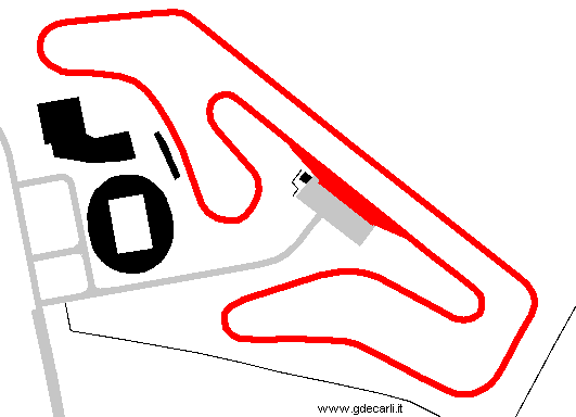
| Description | At first Scuderia San Marco proposed a circuit 1.6 km - 1 mi long (approx). By the good offices of Venezia Town Council, in Spring 1975 new circuit was proposed, 3,8 km long. After 10 years without any news, the same circuit was proposed unchanged on April 26th 1985. | ||||||||||||||||
| Location | Venezia VE - Venezia - Veneto | ||||||||||||||||
| Location | Approx. 10 km - 6.5 mi from Venice Tessera Marco Polo airport | ||||||||||||||||
| Latitude - Longitude (approx) | + 45°29'41" + 12°20'34" (approx) 45.494722 12.342778 (approx) | ||||||||||||||||
| UTM Coordinates (approx) | X = 292381.54 - Y = 5041344.916 - Zone 33T (approx) | ||||||||||||||||
| Aerial photo / Map (*) |  Google Maps - Bing Maps - Flash Earth - Portale Cartografico Nazionale - Visual Pagine Gialle Google Maps - Bing Maps - Flash Earth - Portale Cartografico Nazionale - Visual Pagine Gialle | ||||||||||||||||
| Altitude AMSL (approx) | 1 m - 3 ft (approx) | ||||||||||||||||
| Inauguration | |||||||||||||||||
| Closing | |||||||||||||||||
| Designer | |||||||||||||||||
| Sources and links (Translation) (**) |
| ||||||||||||||||
| San Marco | |||||
| Description | |||||
| Years | |||||
| Direction | |||||
 Proposal Proposal |
YES
| ||||
| Proposal not developed | YES | ||||
| Car Circuit | YES | ||||
| Motorbike circuit | |||||
| Type | Permanent | ||||
| Inauguration | |||||
| Closing | |||||
| Last update of this page | February 21st 2009 | ||||
| Info last update | April 25th 1985 | ||||
| Designer | |||||
| Distinctive points | |||||
| length | 1600 m | 5249 ft | 0.994 mi | Short circuit | (3) |
| length | 3800 m | 12467 ft | 2.361 mi | Full circuit | (4) |
| length | 3800 m | 12467 ft | 2.361 mi | Full circuit | (3) |
Venezia San Marco: 1975 and 1985 proposal
| Updates | |||||||
| Date | Track layout | Years | Description by | Map by | Thanks to | Note | |
| February 21st 2009 | San Marco | Guido de Carli | Update | Description | |||
| April 9th 2005 | San Marco | Guido de Carli | Update | Description | |||
| November 7th 2003 | San Marco | Guido de Carli | Update | Description | |||
| October 12th 2003 | San Marco | Guido de Carli | Update | Description | |||
| Not all eventual updates issued in last years are already visible in this list | |||||||
Webmaster:
Guido de Carli

(Italiano - English - Español)
HOME PAGE